Report on Ambae (Vanuatu) — January 1995
Bulletin of the Global Volcanism Network, vol. 20, no. 1 (January 1995)
Managing Editor: Richard Wunderman.
Ambae (Vanuatu) Volcanic seismicity felt during 1-7 December
Please cite this report as:
Global Volcanism Program, 1995. Report on Ambae (Vanuatu) (Wunderman, R., ed.). Bulletin of the Global Volcanism Network, 20:1. Smithsonian Institution. https://doi.org/10.5479/si.GVP.BGVN199501-257030
Ambae
Vanuatu
15.389°S, 167.835°E; summit elev. 1496 m
All times are local (unless otherwise noted)
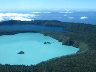
Unusual seismicity was felt by island residents during 1-7 December 1994, with a maximum of seven small-to-medium events on the 5th. These volcanic events were of high-frequency and lacked individualized phases. At the suggestion of ORSTOM, the National Disaster Management Office (NDO) organized a helicopter reconnaissance on 7 December to inspect the volcano for evidence of possible eruptive activity. Activity at the Lake Vui crater and the fumarolic area on the shore of Lake Manoro was similar to that observed during previous aerial observations on 24 July 1991 and September 1993. At Lake Voui, small areas of hot and gaseous water were evident and the rainforest was completely burned around the crater. No large bubbles like those noted on 13 July 1991 (10 m in diameter) were observed (BGVN 16:07). An automated seismic alert station, with satellite transmission to Port Vila, will be installed near Lake Voui.
Geological Summary. The island of Ambae, also known as Aoba, is a massive 2,500 km3 basaltic shield that is the most voluminous volcano of the New Hebrides archipelago. A pronounced NE-SW-trending rift zone with numerous scoria cones gives the 16 x 38 km island an elongated form. A broad pyroclastic cone containing three crater lakes (Manaro Ngoru, Voui, and Manaro Lakua) is located at the summit within the youngest of at least two nested calderas, the largest of which is 6 km in diameter. That large central edifice is also called Manaro Voui or Lombenben volcano. Post-caldera explosive eruptions formed the summit craters about 360 years ago. A tuff cone was constructed within Lake Voui (or Vui) about 60 years later. The latest known flank eruption, about 300 years ago, destroyed the population of the Nduindui area near the western coast.
Information Contacts: M. Monzier, ORSTOM and Vanuatu Department of Geology, Mines and Water Resources, Vanuatu.

