Report on Fernandina (Ecuador) — January 1995

Bulletin of the Global Volcanism Network, vol. 20, no. 1 (January 1995)
Managing Editor: Richard Wunderman.
Fernandina (Ecuador) Lava escapes on SW flank and flows 5 km to enter the ocean
Please cite this report as:
Global Volcanism Program, 1995. Report on Fernandina (Ecuador) (Wunderman, R., ed.). Bulletin of the Global Volcanism Network, 20:1. Smithsonian Institution. https://doi.org/10.5479/si.GVP.BGVN199501-353010
Fernandina
Ecuador
0.37°S, 91.55°W; summit elev. 1476 m
All times are local (unless otherwise noted)
Fernandina... is erupting... from a fissure on its outer flank (figure 1). The last flank eruption, in 1968, was followed by a 350-m collapse of the central caldera floor, and the eight eruptions since then have all been within the caldera or on its rim.
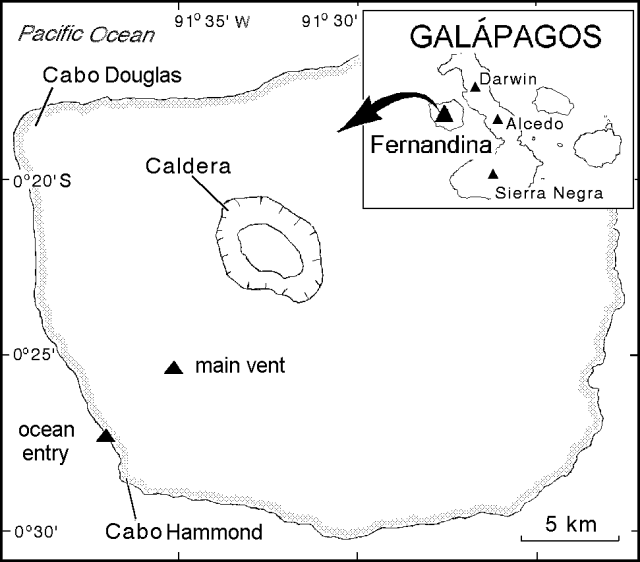 |
Figure 1. Sketch map of Fernandina showing preliminary locations of the ocean entry and main vent. Some estimates suggest the main vent was closer to the sea, only 2 km inland. The index map is incomplete in its portrayal of both volcanoes and islands of the Archipelago. |
On the evening of 25 January distant observers saw a red glow over Fernandina. Closer inspection a day and a half later revealed lava erupting from a radial fissure on the island's SW flank and flowing ~5 km to the ocean (figure 1). At the ocean entry, lava constructed a delta and, although reports suggested a possible decrease in lava output after 13 February, the eruption continued as of last report (mid-Feb).
According to Jim Stimac, the eruption was first sighted at about 1930 on 25 January, when Lenin Cruz, on a fishing boat 140 km E of Fernandina, noticed a red-orange glow on the horizon lingering after sunset. About 50 minutes later, volcanologists Stimac and Fraser Goff also noticed the glow from their campsite on the NW rim of Sierra Negra volcano, ~ 65 km SE. By 2040 they saw glow both from a rising plume over the SW flank and from the summit caldera, which had just cleared of clouds. The glow persisted until dawn. At 0630 the next morning they could see a plume ~4 km high rising from the SW flank of Fernandina. On this and following days the eruption was also witnessed from fishing boats and official Ecuadorian vessels.
As Stimac and others approached Fernandina on the morning of 27 January, they saw two distinct plumes from gases rising over the fissure vent, and from steam over the ocean entry. The two plumes coalesced, rose 3-4 km, and were blown to the W as a white plume. A red-brown haze layer was visible downwind of the vertical plume, and a bluish color was seen above the fissure. After sunset on 27 January, the fissure, a sinuous lava flow, and the ocean entry were more clearly visible. Lava flowing in a narrow active channel near the vent traveled at 3-5 m/s. The larger velocity was similar to values estimated later from videos. Stimac made an order-of-magnitude lava output estimate. Based on the larger velocity, and a 10-m width by a 3-m depth the output was about 1.3 x 10⁷ m3/day.
On both the evening of 28 January and the morning of 29 January the fissure vent was several hundred meters in length, with three distinct fountains. The highest fountaining issued from the upper two vents, and the highest-thrown bombs took 3-5 seconds to fall indicative of 45-125 m fountain heights. The upper fountain produced the finest tephra (most vesicles, highest proportion of vesicles to glass) and probably had the highest gas-to-lava ratio. The middle fountain produced larger bombs. Whereas the upper two fountains were vertical, the lowest vent sent material laterally downslope. Tephra were found as far as 1 km from the vent; near the fissure, they were generally <1 cm in diameter. The tephra consisted of amber-brown vesicular glass with 5-10% plagioclase phenocrysts.
By sunrise on 28 January, an asymmetric spatter-cone several meters high had grown around the main fissure vent, and by the next morning, it had reached 20-30 m high. Clear weather on 29 January unveiled at least two other recently active vents, burnt vegetation, and fresh lava located on higher ground on the SW flank. These observations, combined with those of 25 January, suggested to Stimac that the eruption began inside the caldera, but shifted almost immediately to the radial flank fissures. The caldera, however, has not been visited since the eruption began. Stimac left Fernandina on 29 January, but he saw activity at the main vent episodically, as conditions permitted, from Alcedo volcano (~45 km E) until he left the islands on 14 February.
Within about a kilometer of the main vent and lava channel, Palo Santo trees were felled or broken. Tui De Roy described them as broken by "violent turbulence" and noted they had fallen in seemingly random directions around what she inferred as the early vents.
The translucent, bluish gas plume above the fissure was typically a few hundred meters wide and it rose 100-500 m high before forming turbulent white steam clouds. Observers smelled no sulfur gases but an acrid smell was attributed to unseen, but suspected, burned vegetation. Falling rain irritated eyes and also could have damaged foliage.
Godfrey Merlen's report on the eruption follows. "Although some new lava fields have been created, the eruption has settled into a pattern with fountaining lava (30-200 m) forming scoria ridges alongside its fissure. It seems that initially the active fissure extended for ~ 1.5 km, but later lava extrusion was restricted to ~ 400 m (29 January). However, a film taken on 2 February, seems to show an increase in the length of the erupting fissure. A river of lava ~ 100 m wide is seen flowing to the sea, ~ 5 km away, where new land is slowly being formed. The front entering the sea is ~ 800-m wide."
At the ocean entry, the lava had several active channels, and several that were recently abandoned. Near the ocean entry, observers identified 15 fish species of dead fish, including some that live at moderate depths. The normally dark-green seawater abruptly changed to yellow green at a distance of ~ 900 m from the ocean entry. Ambient sea surface temperature was ~ 25°C at distance from the eruption, but in the yellow-green area it reached 32°C. On 28 January, ponded lava drained rapidly into the sea. At a location 200 m out from the ocean entry, steam rose from the surface and the sea-surface temperature exceeded the thermometer's range (>60°C). Cold surface water was also detected (19.6°C or ~5°C below ambient); it may have risen from depth when displaced by encroaching lava.
Tui De Roy noted that the eruption appeared to change in character after 13 February when flow-filled channels caused new lava to spread out into smaller lobes with less of a trough-shaped morphology. She also noted that the amber-colored, W-directed plume was visible for tens of kilometers.
Although the eruption has yet to be imaged from space, and the TOMS is currently inoperative, the eruption has been documented on film by local and visiting scientists, and a Japanese public television crew. The TV crew's producer, Hiromichi Iwasaki, described a 1.5-km radius of discolored water around the entry, and rain due to condensed steam. Tui De Roy reported that the eruption took a considerable toll on wildlife, as many fish died and this attracted seabirds who dove into the heated waters and were scalded to death.
The eruption followed an increase in seismicity in and near the western Galápagos. A mb 5.1 earthquake at 1811 on 14 December was recorded by the NEIC. Another (mb 5.1) was recorded at 1330 on 11 January, following five smaller events the previous day on the transform fault about 200 km NNE of Fernandina. We have also received reports of local earthquakes felt on Alcedo volcano (~45 km E).
Fernandina also erupted in 1991, 1988, 1984, 1981 (± 1), and 17 to 18 other times in a historical record going back as far as 1813. Most of these eruptions were of short duration and located in or near the summit caldera.
Geological Summary. Fernandina, the most active of Galápagos volcanoes and the one closest to the Galápagos mantle plume, is a basaltic shield volcano with a deep 5 x 6.5 km summit caldera. The volcano displays the classic "overturned soup bowl" profile of Galápagos shield volcanoes. Its caldera is elongated in a NW-SE direction and formed during several episodes of collapse. Circumferential fissures surround the caldera and were instrumental in growth of the volcano. Reporting has been poor in this uninhabited western end of the archipelago, and even a 1981 eruption was not witnessed at the time. In 1968 the caldera floor dropped 350 m following a major explosive eruption. Subsequent eruptions, mostly from vents located on or near the caldera boundary faults, have produced lava flows inside the caldera as well as those in 1995 that reached the coast from a SW-flank vent. Collapse of a nearly 1 km3 section of the east caldera wall during an eruption in 1988 produced a debris-avalanche deposit that covered much of the caldera floor and absorbed the caldera lake.
Information Contacts: J. Stimac, LANL, Los Alamos; G. Merlen, Estacion Cientifica Charles Darwin; H. Iwasaki, Nippon Hoso Kyokai (Japan Broadcasting Corporation), Tokyo; T. De Roy, Golden Bay, New Zealand; NEIC.