Report on Long Valley (United States) — March 1995

Bulletin of the Global Volcanism Network, vol. 20, no. 3 (March 1995)
Managing Editor: Richard Wunderman.
Long Valley (United States) Summary of 1994 seismicity, deformation, and CO2 discharge
Please cite this report as:
Global Volcanism Program, 1995. Report on Long Valley (United States) (Wunderman, R., ed.). Bulletin of the Global Volcanism Network, 20:3. Smithsonian Institution. https://doi.org/10.5479/si.GVP.BGVN199503-323822
Long Valley
United States
37.7°N, 118.87°W; summit elev. 3390 m
All times are local (unless otherwise noted)
The following summarizes more detailed reports (Hill, 1995; Johnson and others, 1995; and Sorey and others, 1995) on caldera seismicity, deformation, and CO2 discharge at Mammoth Mountain during 1994.
Earthquake activity within the caldera gradually decreased through the first months of 1994, and activity thereafter remained moderate with a few exceptions. During the entire year there were only ten-twelve M ~3 earthquakes in the caldera, in comparison with 30 in 1993. The earthquakes continued to cluster in the caldera's S moat, and gradually moved northward. During 1994, earthquakes with M <2 took place beneath Mammoth Mountain at depths of 4-20 km.
Seismicity in the Sierra Nevada block, S of the caldera, persisted at a moderate level throughout the year and was concentrated in a broad band extending S from Mount Morrison to Red Slate Mountain. In the Chalfant Valley, E of the Long Valley Caldera and W of the White Mountains, over 20 M ~3 earthquakes occurred throughout 1994, with many smaller late M <2 aftershocks associated with the M 6.4 Chalfant Valley earthquake of 1986.
Swelling of Long Valley's resurgent dome continued at a steady rate of 2-3 ppm/year, resembling 1993 activity. Deformation measurements, using a two-color geodetic distance-meter (geodimeter), revealed steady extension rates to the N and E of a central survey site (CASA, figure 17) from mid-1991 through the end of 1994. To the W and SW of CASA, extension rates gradually decelerated beginning in mid-to-late 1993 and continuing through 1994.
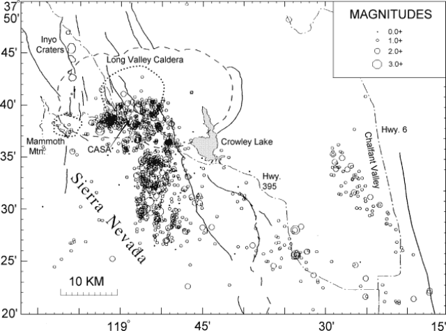 |
Figure 17. Earthquake epicenters in the Long Valley region, 1994. Modified from Hill (1995). |
Dead mature pine trees were found in four separate areas on the flanks of Mammoth Mountain during 1994. Reports of asphyxia among workers entering poorly ventilated parts of the tree kill areas and an area near the top of the Chair 3 ski lift were also recorded during 1994, and were correlated with high (10-90%) CO2 concentrations in the soils (Sorey and others, 1995). The area of tree mortality has expanded since 1989, when the first tree death was reported. Several explanations have been put forward, including: 1) dike intrusion during the intense earthquake swarm below Mammoth Mountain of April-December 1989; 2) ongoing shallow silicic magma intrusion; 3) ongoing input of basaltic magma from a deeper source associated with the long-period earthquakes that began in 1989; and 4) gas release from a volatile-rich vapor zone surrounding areas of previously emplaced igneous rocks.
References: Hill, David P., 1995, Long Valley Caldera Monitoring Report (Oct - Dec 1994): U.S. Geological Survey, Office of Earthquakes, Volcanoes, and Engineering, 345 Middlefield Rd. Menlo Park, CA 94025, 16 p.
Sorey, Mike, Evans, Bill, and Farrar, Chris, 1994, Gas composition and discharge rate at Mammoth Mountain, in Hill, 1995, Long Valley Caldera Monitoring Report (Oct - Dec 1994): U.S. Geological Survey, 2 p.
Geological Summary. The large 17 x 32 km Long Valley caldera east of the central Sierra Nevada Range formed as a result of the voluminous Bishop Tuff eruption about 760,000 years ago. Resurgent doming in the central part of the caldera occurred shortly afterwards, followed by rhyolitic eruptions from the caldera moat and the eruption of rhyodacite from outer ring fracture vents, ending about 50,000 years ago. During early resurgent doming the caldera was filled with a large lake that left strandlines on the caldera walls and the resurgent dome island; the lake eventually drained through the Owens River Gorge. The caldera remains thermally active, with many hot springs and fumaroles, and has had significant deformation, seismicity, and other unrest in recent years. The late-Pleistocene to Holocene Inyo Craters cut the NW topographic rim of the caldera, and along with Mammoth Mountain on the SW topographic rim, are west of the structural caldera and are chemically and tectonically distinct from the Long Valley magmatic system.
Information Contacts: D. Hill, USGS Menlo Park.