Report on Pinatubo (Philippines) — June 1995
Bulletin of the Global Volcanism Network, vol. 20, no. 6 (June 1995)
Managing Editor: Richard Wunderman.
Pinatubo (Philippines) Lahars and a secondary explosion reaching over 9 km in altitude
Please cite this report as:
Global Volcanism Program, 1995. Report on Pinatubo (Philippines) (Wunderman, R., ed.). Bulletin of the Global Volcanism Network, 20:6. Smithsonian Institution. https://doi.org/10.5479/si.GVP.BGVN199506-273083
Pinatubo
Philippines
15.13°N, 120.35°E; summit elev. 1486 m
All times are local (unless otherwise noted)
In the first half of July, a secondary explosion and several lahars occurred on Pinatubo's flanks. An 11 July secondary explosion vented from a still-hot pyroclastic-flow deposit in the Sacobia fan, escaping at a spot ~10 km NE of the active crater. The phreatic explosion was apparently triggered when recently introduced rainwater penetrated into the pyroclastic-flow deposit's interior and flashed into steam. The explosion, first noted by PHIVOLCS at 1506, subsided by 1624. The means of initial detection was unreported, but it was apparently not based on seismic signals.
The plume associated with the explosion reached 9-10 km in altitude. PHIVOLCS reported that ashfall was mainly toward the ENE. Light ash fell at the former Clark Air Force base (~25 km ENE) and nearby, but ash was absent at the town of Dinalupihan, 35 km SSE.Because the eruption did not issue from the volcano itself, PHIVOLCS did not change Pinatubo's hazard status or the 10-km-radius danger zone.
Cloud cover prevented analysts at the NOAA Synoptic Analysis Branch from sighting a plume on GMS satellite imagery. They could determine that winds at 7.6 km altitude blew at ~46 km/hr to the WSW. News of a plume to 9 km altitude from aviation sources prompted them to issue an abbreviated volcanic hazards alert, and the NOAA National Meteorological Center (NMC) to run the VAFTAD plume trajectory model (BGVN 19:06) for dissemination over weather distribution systems and display on the Internet. Both the hazards alert and the plume trajectory model served to alert pilots, air traffic controllers, and airline dispatchers of the potentially hazardous plume.
Besides using NMC forecast meteorology, the input parameters for the modelling run included Pinatubo's active crater coordinates, and an assumed hour-long sustained eruption to 9 km. In essence, the run suggested that after about 12 hours in the 0-6 km altitude range the ash plume was widely dispersed and included the area to the ENE where ash was found on the ground.
At higher altitudes (6-11 km), the model suggested a gradual drift of the ash plume, primarily toward the W and SW. Although this higher altitude result was not confirmed by ground observations, it suggests possible westward transport of suspended particulates that may have only fallen in amounts too small to detect with simple field techniques.
Lahars came down the SE-flank Pasig-Potrero river twice on 7 July, once on 9 July, and twice on 11 July. Some lahars reached 3-4 m in thickness, breaching inner dikes and thinning the line of defense for San Fernando, a settlement 40 km SE of Pinatubo (at the confluence of the Palawi and San Fernando rivers).
Lahars have followed these and other drainages (BGVN 18:08, 18:09, and 19:08) during every rainy season since the paroxysmal 15 June 1991 eruption. PHIVOLCS expects that both secondary phreatic explosions and lahars will recur as the monsoon season continues.
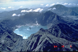
Geological Summary. Prior to 1991 Pinatubo volcano was a relatively unknown, heavily forested lava dome complex located 100 km NW of Manila with no records of historical eruptions. The 1991 eruption, one of the world's largest of the 20th century, ejected massive amounts of tephra and produced voluminous pyroclastic flows, forming a small, 2.5-km-wide summit caldera whose floor is now covered by a lake. Caldera formation lowered the height of the summit by more than 300 m. Although the eruption caused hundreds of fatalities and major damage with severe social and economic impact, successful monitoring efforts greatly reduced the number of fatalities. Widespread lahars that redistributed products of the 1991 eruption have continued to cause severe disruption. Previous major eruptive periods, interrupted by lengthy quiescent periods, have produced pyroclastic flows and lahars that were even more extensive than in 1991.
Information Contacts: Emmanuel G. Ramos, Deputy Director, Philippine Institute of Volcanology and Seismology (PHIVOLCS), 6th Floor, Hizon Building, 29 Quezon Avenue, Quezon City, Philippines; Grace Swanson and Jim Lynch, NOAA/NESDIS Synoptic Analysis Branch (SAB), Room 401, 5200 Auth Road, Camp Springs, MD 20746, USA; Nick Heffter, NOAA Air Resources Laboratory, SSMC3, Room 3151, 1315 East West Hwy, Silver Spring, MD 20910 USA.

