Report on Bezymianny (Russia) — September 1995
Bulletin of the Global Volcanism Network, vol. 20, no. 9 (September 1995)
Managing Editor: Richard Wunderman.
Bezymianny (Russia) Explosive eruption causes 2-3 mm of ashfall 50 km away
Please cite this report as:
Global Volcanism Program, 1995. Report on Bezymianny (Russia) (Wunderman, R., ed.). Bulletin of the Global Volcanism Network, 20:9. Smithsonian Institution. https://doi.org/10.5479/si.GVP.BGVN199509-300250
Bezymianny
Russia
55.972°N, 160.595°E; summit elev. 2882 m
All times are local (unless otherwise noted)
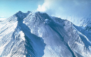
At 0500 on 6 October, regional seismic stations began to record volcanic tremor with a maximum amplitude of 5-6 µm. An ash plume was detected by the Alaska Volcano Observatory (AVO) on a satellite image taken at 0824. The Institute of Volcanology (IV) reported that an eruptive column first appeared over Bezymianny around that time, and by 0900 it was ~8 km high. Weather satellite imagery at 0948 showed that the plume had reached the coastline nearly due E, with a top estimated to be 10 km above sea level.
At 0930, volcanic ash started to fall in Kliuchi, ~50 km NNE. Tremor and ash emission increased up to 1200, followed by 3 hours of intense ashfall; during a period of 140 minutes 700 g/m2 of ash fell in Kliuchi. Because the air in Kliuchi was strongly polluted with volcanic gas, a warning was issued for the residents to take precautions. From Kliuchi, E. Zhdanova, a volcanologist from the Institute of Volcanic Geology and Geochemistry (IVGG), reported that ashfall had stopped at about 1700 on 6 October after 2-3 mm of deposition. AVO satellite imagery at 1813 showed the disconnected ash plume ~150 km E. The plume was moving ENE and was over 400 km from the source. By about 0930 on 7 October, the ash plume had undergone significant diffusion and was no longer detectable on satellite images.
As of the morning of 7 October the volcano was obscured, but there was no more tremor. Zhdanova suggested that the explosive phase of the eruption had ended and a lava dome was forming again. This interpretation was confirmed by a large hot spot seen at the vent on AVHRR imagery after the ash cloud had disconnected from the volcano.
Geological Summary. The modern Bezymianny, much smaller than its massive neighbors Kamen and Kliuchevskoi on the Kamchatka Peninsula, was formed about 4,700 years ago over a late-Pleistocene lava-dome complex and an edifice built about 11,000-7,000 years ago. Three periods of intensified activity have occurred during the past 3,000 years. The latest period, which was preceded by a 1,000-year quiescence, began with the dramatic 1955-56 eruption. This eruption, similar to that of St. Helens in 1980, produced a large open crater that was formed by collapse of the summit and an associated lateral blast. Subsequent episodic but ongoing lava-dome growth, accompanied by intermittent explosive activity and pyroclastic flows, has largely filled the 1956 crater.
Information Contacts: Alaska Volcano Observatory; E. Zhdanova and V. Kirianov, Institute of Volcanic Geology & Geochemistry, Piip Avenue 9, Petropavlovsk-Kamchatsky, 683006, Russia; N.A. Zharinov and S.A. Fedotov, Institute of Volcanology, Petropavlovsk-Kamchatsky, 683006, Russia.