Report on Cerro Negro (Nicaragua) — September 1995
Bulletin of the Global Volcanism Network, vol. 20, no. 9 (September 1995)
Managing Editor: Richard Wunderman.
Cerro Negro (Nicaragua) Small lava flows in main crater; ash eruptions end in mid-August
Please cite this report as:
Global Volcanism Program, 1995. Report on Cerro Negro (Nicaragua) (Wunderman, R., ed.). Bulletin of the Global Volcanism Network, 20:9. Smithsonian Institution. https://doi.org/10.5479/si.GVP.BGVN199509-344070
Cerro Negro
Nicaragua
12.506°N, 86.702°W; summit elev. 728 m
All times are local (unless otherwise noted)
Increased seismicity was detected at and up to 15 km around Cerro Negro during 24-28 May. Ash plumes to ~100 m above the crater rim were first observed on 29 May (or the afternoon of 28 May). The eruptions (1-2/hour) correlated with periods of increased seismic activity. On 1 June, the seismicity increased in frequency and intensity, with eruptions occurring about every 15 minutes. Fine-grained ash, consisting primarily of free crystals with minor amounts of basaltic fragments, was deposited N of the cone (figure 7). Bulk density of the ash deposit was measured at 1.3 +- 0.2 g/cm3. Trace amounts of ash (0.5 mm) from eruptions on 2-5 June fell as far N as Malpaisillo (figure 7), with 1-mm ash thicknesses extending 5 km N of the vent. This deposit represents 1 x 10⁴ m3 of ash, equivalent to an eruption rate of 100 m3/hour.
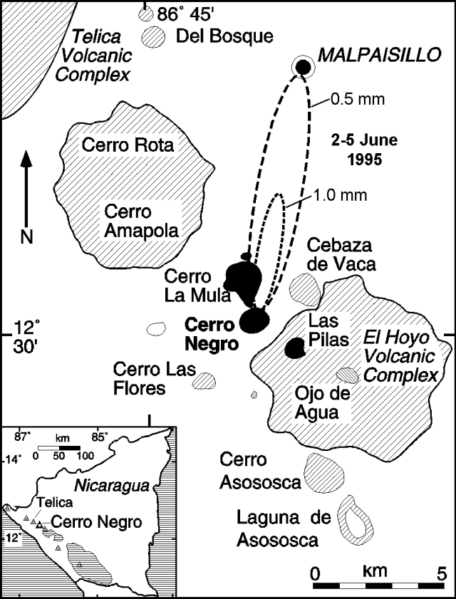 |
Figure 7. Location map of Cerro Negro and adjacent volcanoes, Nicaragua. Dashed ellipses show the interpreted extent of 0.5- and 1-mm-thick ash deposits for 2-5 June 1995 activity. Courtesy of Brittain Hill. |
Eruptive activity was observed and recorded during 2-5 June, 6 June-1 July, and 24 July-16 August. During this time, activity was characterized by discrete explosions occurring on average every 8 +- 5 minutes. There was no apparent periodicity to the explosions, although patterns of increasing and decreasing repose times were apparent. These explosions commonly produced convective columns at least 400 m above the cone, and sometimes rising ~1 km; many produced ballistically transported blocks. Most blocks fell within the crater, but some occasionally impacted as far as half way down the outer slope of the cone. Blocks that reached maximum heights (100 m) and distances had estimated ejection velocities of 100-120 m/second.
The most intense activity was observed just before noon on 2 June, when a small dilute pyroclastic flow formed on the NW flank of the cone during an explosion. Deposits from this flow were found on the NW flank and extended <100 m from the base. The massive, fine-grained (<1 mm median diameter), and very well sorted deposit was ~1 cm thick on the cone slope and covered very fine ash from 29 May-1 June explosions. Although this deposit has the high degree of sorting and grain-size characteristics of surges, sorting is better than commonly observed in basaltic surge deposits (Wohletz, 1983). One explanation for this high degree of sorting is that the deposit was produced from a dilute, relatively low energy surge, which lacks a magmatic component common in most other basaltic surge deposits (Wohletz and Sheridan, 1979). This interpretation is consistent with the generally phreatic character of the eruption.
Seismic activity increased markedly on 24 July, with sustained periods of nearly constant tremor. A small lava flow formed in the E part of the main crater on 24-25 July. Ash eruptions during and after the lava emission continued at the same apparent frequency and magnitude as before. A sporadic increase in seismicity on 3 August was accompanied by increased degassing from within the crater. However, there was no associated increase in the number or magnitude of ash eruptions. Eruptive activity decreased significantly on 15 August, and ceased on 16 August.
Soil radon concentrations were monitored at 28 stations deployed around the base of Cerro Negro during early June. These stations were located near a permanent seismic station on the SSE side of the volcano, and on and near the Cerro La Mula Ridge, which extends NW from Cerro Negro (figure 7). Anomalously high radon concentrations were observed at nearly all of these stations during 2-3 June. At one station (700 m SSE of the crater), the radon concentration was 396 pCi/L on 2-3 June and 146 pCi/L on 3-4 June, compared with 17 pCi/L previously measured (Conway and others, 1994). Anomalous values (100-1,000x background) also were observed on 2-3 June at stations located up to 800 m N of the crater. Radon concentrations had dropped to near background levels at most stations by 4-5 June, but eruptive activity continued with little change. We conclude that a pulse of soil degassing occurred during the initial stages of the eruption, likely associated with dike injection and fracturing of wallrock.
A self-potential anomaly across Cerro La Mula Ridge, 750 m N of the active crater, correlated with the location of low-temperature fumaroles (60-88°C), and radon anomalies. Temperature increases of ~30°C were measured in this area, associated with the 1995 eruptive activity. Continuous monitoring of the self-potential anomaly on 4-5 June revealed amplitude changes corresponding to diurnal changes in air and ground temperatures, and periods of rainfall.
Preliminary ash-leachate studies by M. Navarro show low total S and Cl, along with low S/Cl, consistent with lack of a juvenile component in the ejecta. In addition, the regularity of the eruptions, the consistent fine grain-size of the deposits, and lack of obvious juvenile components support the interpretation of activity as dominantly phreatic. The heat needed to drive this event was provided by the intrusion of a small volume of magma into the shallow subsurface. Evidence for the presence of new magma includes the eruption of lava on 24-25 July, observed patterns of seismicity, increased temperature and radon flux in thermal areas, and the relatively constant periodicity of eruptions over the days of direct observation.
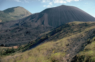
Cerro Negro is the site of the most recent small-volume basaltic eruption at a cinder cone in the western hemisphere, having last erupted in April 1992 (Connor and others, 1993). Cerro Negro first erupted in 1850, with at least 19 documented eruptions occurring up to April 1992. The longest eruption occurred in 1960, when activity persisted for approximately three months. Cerro Negro is characterized by unusually explosive eruptions, and may represent the upper end of basaltic eruption explosivities. Preliminary research suggests that this explosivity may be controlled by relatively high magmatic water contents (>2 weight percent) associated with highly crystalline, viscous magmas (Roggensack and others, 1994).
References. Connor, C.B, Powell, L., Strauch, W., Navarro, M., Urbina, O., and Rose, W.I., 1993, The 1992 eruption of Cerro Negro, Nicaragua: An example of Plinian-style activity at a small basaltic cinder cone: EOS, Transactions of the American Geophysical Union v. 74, no. 43, p. 640.
Conway, F.M., Macfarlane, A.W., Connor, C.B., LaFemina, P.C., and Reimer, M., 1994, Degassing at a young cinder cone: Volcan Cerro Negro: Geological Society of America, 1994 Annual Meeting Abstracts with Program, 26 (7), p. A453.
Roggensack, K., Williams, S.N., Hervig, R.L., McKnight, S.B., Connor, C.B., and Navarro, M., 1994, Evidence of polybaric fractionation: Melt inclusions in 1992 eruption of Cerro Negro volcano, Nicaragua: EOS, Transactions of the American Geophysical Union, v. 75, no. 44, p. 747.
Wohletz, K.H., 1983, Mechanisms of hydrovolcanic pyroclast formation: grainþsize, scanning electron microscopy, and experimental studies: Journal of Volcanology and Geothermal Research, v. 17, p. 31-63.
Wohletz, K.H., and Sheridan, M.F., 1979, A model of pyroclastic surge: Geological Society of America Special Paper 180, Boulder, CO, p. 177-194.
Geological Summary. Nicaragua's youngest volcano, Cerro Negro, was created following an eruption that began in April 1850 about 2 km NW of the summit of Las Pilas volcano. It is the largest, southernmost, and most recent of a group of four youthful cinder cones constructed along a NNW-SSE-trending line in the central Marrabios Range. Strombolian-to-subplinian eruptions at intervals of a few years to several decades have constructed a roughly 250-m-high basaltic cone and an associated lava field constrained by topography to extend primarily NE and SW. Cone and crater morphology have varied significantly during its short eruptive history. Although it lies in a relatively unpopulated area, occasional heavy ashfalls have damaged crops and buildings.
Information Contacts: Martha Navarro, Oscar Canales, and Wilfried Strauch, Instituto Nicaraguense de Estudios Territorales, Managua, Nicaragua; Brittain E. Hill, Charles B. Connor, F. Michael Conway, and Peter LaFemina, Center for Nuclear Waste Regulatory Analyses, Southwest Research Institute, 6220 Culebra Rd., San Antonio, TX 78238-5166 USA.