Report on Llaima (Chile) — October 1995
Bulletin of the Global Volcanism Network, vol. 20, no. 10 (October 1995)
Managing Editor: Richard Wunderman.
Llaima (Chile) Minor eruption just after a M 4.0 earthquake 160 km to the east
Please cite this report as:
Global Volcanism Program, 1995. Report on Llaima (Chile) (Wunderman, R., ed.). Bulletin of the Global Volcanism Network, 20:10. Smithsonian Institution. https://doi.org/10.5479/si.GVP.BGVN199510-357110
Llaima
Chile
38.692°S, 71.729°W; summit elev. 3125 m
All times are local (unless otherwise noted)
Beginning on 13 October 1995 Llaima started emitting gases and occasional ash; in addition, during the night the northern principal crater glowed a rose color. Dominant winds dispersed the eruptive columns toward the SE on 13 October. Three days later, Llaima started emitting a continuous, strong blast of steam that occasionally also contained dark-gray scrolls bearing fine-grained ash. The resulting plume blew NE.
On the night of 20-21 October, the principal crater discharged a strong explosion. Wind carried ash toward the SW, depositing it on the alpine ice. Some ash fell over the Trufultruful valley and the valley's most eastern flanking hills, forming a band or stripe up to 12 km in length.
On 21 October between 1600 and 1800 the volcano gave off a continuous, intense column of vapor and ash. That night, between 2300 and 0100 in the town of Conguillio, residents heard an explosion accompanied by subterranean noises. The following night, observers saw a "ring of fire" over the principal crater, an effect thought to indicate the presence of lava within the crater.
The Servicio Sismologico de la Universidad de Chile reported that seismic activity one day before the eruption, on 12 October, included a M 4.0 earthquake that struck the region; its depth was 70 km; its epicenter fell at the extreme S end of Lake Lieulleu in the Cordillera de Nahuelbuta (38.28°S, 73.408°W), a spot about 160 km E of Llaima. During 20 and 22 October, portable seismometers picked up 1.0-1.5 Hz tremor; on 20 October the tremor appeared about 15-20 seconds before the above-mentioned explosion. It should be noted that such sub-continuous episodes of 1.0-1.5 Hz tremor are relatively rare at Llaima.
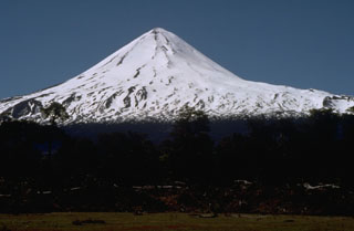
The 13-22 October eruptions followed fumarolic activity (BGVN 20:02) and, before that, an outbreak of ash-bearing eruptions in late August 1994 (BGVN 19:08). On the basis of the above behavior, the 24 October SERNAGEOMIN report stated that the volcano had been assigned an alert status of yellow. Llaima, an ice- and snow-covered stratovolcano, is one of the largest and most active in Chile; it erupted in 1990, 1992, and 1994.
Geological Summary. Llaima, one of Chile's largest and most active volcanoes, contains two main historically active craters, one at the summit and the other, Pichillaima, to the SE. The massive, dominantly basaltic-to-andesitic, stratovolcano has a volume of 400 km3. A Holocene edifice built primarily of accumulated lava flows was constructed over an 8-km-wide caldera that formed about 13,200 years ago, following the eruption of the 24 km3 Curacautín Ignimbrite. More than 40 scoria cones dot the volcano's flanks. Following the end of an explosive stage about 7200 years ago, construction of the present edifice began, characterized by Strombolian, Hawaiian, and infrequent subplinian eruptions. Frequent moderate explosive eruptions with occasional lava flows have been recorded since the 17th century.
Information Contacts: Hugo Moreno1, Gustavo Fuentealba, and Paola Pena, Observatorio Volcanologico de los Andes del Sur, SERNAGEOMIN, Temuco, Chile.