Report on Maderas (Nicaragua) — September 1996
Bulletin of the Global Volcanism Network, vol. 21, no. 9 (September 1996)
Managing Editor: Richard Wunderman.
Maderas (Nicaragua) Lahar kills six people
Please cite this report as:
Global Volcanism Program, 1996. Report on Maderas (Nicaragua) (Wunderman, R., ed.). Bulletin of the Global Volcanism Network, 21:9. Smithsonian Institution. https://doi.org/10.5479/si.GVP.BGVN199609-344130
Maderas
Nicaragua
11.446°N, 85.515°W; summit elev. 1394 m
All times are local (unless otherwise noted)
During the night of 27 September, a lahar triggered by unusually heavy rainfalls occurred on the E flank of Maderas and destroyed the village of El Corozal (~3 km from the volcano) and other settlements.
Five children and an adult were killed, and several more people injured. The full extent of the damage became evident only after a few days: rocks, mud, and water had destroyed 36 houses and heavily damaged crops; some areas were covered with 2 m of mud and water. About 250 people were affected by the lahar and evacuated to a local school.
Two policemen, who climbed the volcano two days after the lahar, observed a small crater at the starting point of the lahar. They presumed that a minor volcanic explosion could have triggered the event, but this has not been confirmed by Nicaraguan volcanologists. A local farmer reported a strange thunder sound minutes before the lahar came down.
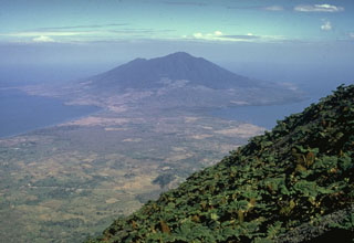
Geological Summary. Volcán Maderas is a roughly conical stratovolcano that forms the SE end of the dumbbell-shaped Ometepe island in Lake Nicaragua. The basaltic-to-trachydacitic edifice is cut by numerous faults and grabens, the largest of which is a NW-SE-oriented graben that cuts the summit and has at least 140 m of vertical displacement. The small Laguna de Maderas lake occupies the bottom of the 800-m-wide summit crater, which is located at the western side of the central graben. The SW side of the edifice has been affected by large-scale slumping. Several pyroclastic cones, some of which may have originated from littoral explosions produced by lava flow entry into Lake Nicaragua, are situated on the lower NE flank down to the level of Lake Nicaragua. The latest period of major growth was considered to have taken place more than 3000 years ago, but later detailed mapping has shown that the most recent dated eruptive activity took place about 70,000 years ago and that it has likely been inactive for tens of thousands of years (Kapelanczyk et al., 2012). A lahar in September 1996 killed six people in an E-flank village, but associated volcanic activity was not confirmed.
Information Contacts: Wilfried Strauch, Instituto Nicaraguense de Estudios Territoriales (INETER), Dept. of Geophysics, Managua, Nicaragua.