Report on Rabaul (Papua New Guinea) — March 1997

Bulletin of the Global Volcanism Network, vol. 22, no. 3 (March 1997)
Managing Editor: Richard Wunderman.
Rabaul (Papua New Guinea) Lava flow issues from Tavurvur crater during 14 March eruption
Please cite this report as:
Global Volcanism Program, 1997. Report on Rabaul (Papua New Guinea) (Wunderman, R., ed.). Bulletin of the Global Volcanism Network, 22:3. Smithsonian Institution. https://doi.org/10.5479/si.GVP.BGVN199703-252140
Rabaul
Papua New Guinea
4.2459°S, 152.1937°E; summit elev. 688 m
All times are local (unless otherwise noted)
On 14 March, a strong Strombolian and lava-producing eruption occurred at Tavurvur, the small active cone on the E side of the Rabaul Caldera (figure 29). This was the third eruption of this type since October 1996 (BGVN 21:12 and 22:01). Two photos of Tavurvur and vicinity from November 1996 show the effects of eruptions since 1994 (figures 30 and 31).
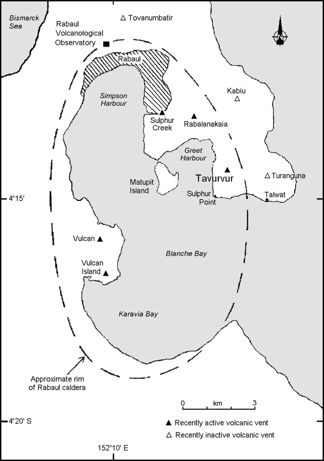 |
Figure 29. Map of Rabaul Caldera showing locations of volcanic vents, selected towns, and features (modified from Almond and McKee, 1982). |
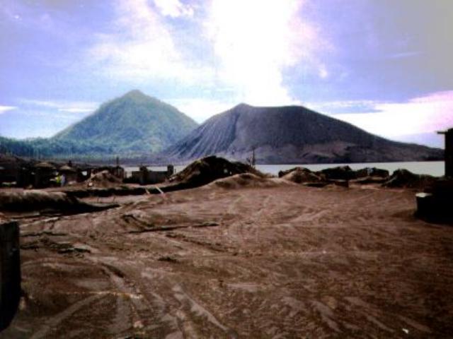 |
Figure 30. Photograph of a weakly steaming Tavurvur cone taken from the peninsula leading to Matupit Island, November 1996. Turanguna cone sits in the background. The abundant ash in the foreground was deposited during the 1994 eruption. Courtesy of Nancy Roper. |
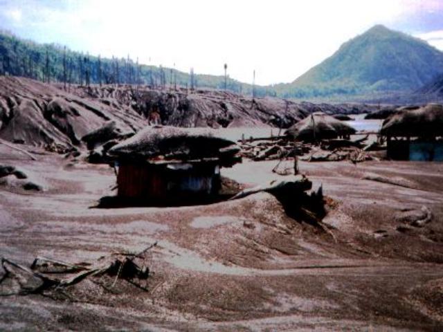 |
Figure 31. Photograph of Tavurvur's extreme N flank (upper right edge), Turanguna (right background), and devastated groves and structures, November 1996. Courtesy of Nancy Roper. |
Emissions from Tavurvur in early March consisted of pale gray vapor clouds that commonly rose ~600 m above the crater. Vulcanian explosions occurred occasionally and were commonly followed by ash emission lasting from 20 minutes to 2 hours. On 6 March, a Vulcanian explosion ejected lithic blocks that fell over the entire cone, the farthest reaching Greet Harbor (1 km from the vent). During the explosion, a small landslide on the NW flank of the volcano left a scar several hundred meters long.
At 0736 on 14 March a large and loud explosion was accompanied by a gray ash-rich eruption plume. Within an hour, Strombolian explosions ejected fragments that showered Tavurvur cone. By 0930, sub-continuous Strombolian eruptions occurred; these commonly produced loud detonations; in addition, flashing arcs were noted in the eruption plume. Some of the explosions sent "large lumps of lava" up to 1 km above the crater at intervals ofBGVN22:01) and partially overrode the October 1996 and January 1997 lava flows. The strength of the eruption did not begin to decrease until about 1530. By 2200 the eruption had declined to discontinuous explosions. Lava reached the sea near Sulphur Point sometime during the night (figure 29).
Due to a strong wind, the eruption plume was dispersed to the SW and remained below 2 km in height. Approximately 2 km SW, the town of Talway accumulated a 13-cm-thick pumiceous deposit. The detonations were very loud in the Kokopo area, 14 km SW. The Tokua airport ~20 km SW was closed for most of the day due to the threat of ashfall.
On 15 March, strong eruptions continued at intervals of minutes to hours and eruption plumes rose 400-600 m. Occasionally a peculiar pulsating roaring sound was heard that generally correlated with periods of harmonic tremor.
The level of activity continued to decrease between 16 and 19 March. There were progressively less frequent, but still loud, explosions with occasional roaring sounds. For the remainder of March, the level of activity was low, with weak white plumes rising to ~500 m above the crater. Occasionally, large explosions sent plumes as high as 3,000 m above the crater.
Seismicity began to increase on 7 March and reached 300 events/day with real-time seismic amplitude measurement (RSAM) levels rising to ~60-120. Levels decreased during 11-12 March but increased again on the 13th. During the eruption on 14 March, RSAM levels reached a plateau of ~ 850, similar to October 1996 and January 1997 eruption levels. By 2200 on 14 March, RSAM levels had dropped to ~100. A few intervals of harmonic tremor were recorded on 18-20, 22, 24-25, and 28 March.
Correlation spectrometer (COSPEC) measurements early in the month revealed SO2 fluxes of 2 fluxes increased to 400-700 tons/day before returning to background levels on 18 March. By the end of March, SO2 fluxes began to rise again.
In response to the eruption, the SCK water-tube tiltmeter 3.3 km NW of Tavurvur showed a radial deflation of 11 µrad (compared to 16 µrad and 11 µrad during the October and January eruptions, respectively). By the end of the month, radial inflation began to increase again.
Reference. Almond, R.A., and McKee, C.O., 1982, Location of volcano-tectonic earthquakes within the Rabaul Caldera: Geological Survey of Papua New Guinea report 82/19.
Geological Summary. The low-lying Rabaul caldera on the tip of the Gazelle Peninsula at the NE end of New Britain forms a broad sheltered harbor utilized by what was the island's largest city prior to a major eruption in 1994. The outer flanks of the asymmetrical shield volcano are formed by thick pyroclastic-flow deposits. The 8 x 14 km caldera is widely breached on the east, where its floor is flooded by Blanche Bay and was formed about 1,400 years ago. An earlier caldera-forming eruption about 7,100 years ago is thought to have originated from Tavui caldera, offshore to the north. Three small stratovolcanoes lie outside the N and NE caldera rims. Post-caldera eruptions built basaltic-to-dacitic pyroclastic cones on the caldera floor near the NE and W caldera walls. Several of these, including Vulcan cone, which was formed during a large eruption in 1878, have produced major explosive activity during historical time. A powerful explosive eruption in 1994 occurred simultaneously from Vulcan and Tavurvur volcanoes and forced the temporary abandonment of Rabaul city.
Information Contacts: B. Talai, H. Patia, D. Lolok, P. de Saint Ours, and C. McKee, Rabaul Volcano Observatory (RVO), P.O. Box 386, Rabaul, Papua New Guinea; Bureau of Meteorology, Northern Territory Regional Office, P.O. Box 735, Darwin, NT 0801 Australia.