Report on Deception Island (Antarctica) — April 1997
Bulletin of the Global Volcanism Network, vol. 22, no. 4 (April 1997)
Managing Editor: Richard Wunderman.
Deception Island (Antarctica) Seismicity lower than previously recorded
Please cite this report as:
Global Volcanism Program, 1997. Report on Deception Island (Antarctica) (Wunderman, R., ed.). Bulletin of the Global Volcanism Network, 22:4. Smithsonian Institution. https://doi.org/10.5479/si.GVP.BGVN199704-390030
Deception Island
Antarctica
62.9567°S, 60.6367°W; summit elev. 602 m
All times are local (unless otherwise noted)
The following describes work completed during the 1996-97 austral summer, carried out from 6 December 1996 to 25 February 1997. The survey scientists deployed magnetometer instruments, gravimeters, and a meteorological station.
Seismicity (figure 11) was monitored with a digital seismic array with 16-bit dynamic range. The array included 24 geophones (24 Mark L4C-L25b). The array was placed in the same location as the 1994-95 and 1995- 95 surveys (BGVN 20:04 and 21:04) but in addition four additional seismometers were installed in active areas of the island to gather information on the spectral characteristics of the volcanic events. The recorded seismic activity was lower in both energy level and number of events than for the previous years.
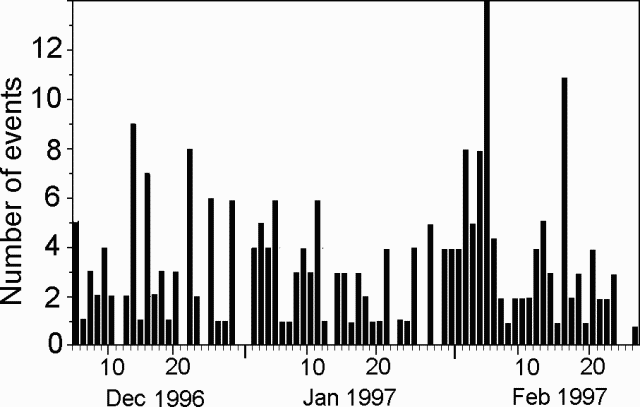 |
Figure 11. Daily occurrence of earthquakes at Deception Island, 6 December 1996-25 February 1997. Courtesy of A. García. |
The recorded events included six intermediate-focus earthquakes, eight regional earthquakes, 13 events with S-P arrival times smaller than 5 seconds and M 2.5, and five volcanic tremors. There were also 119 long-period events and 43 hybrid events, some of which had S-P arrival times under 1 second.
Scientists investigated fumarole geochemistry, thermal anomalies, and rock rheology. Temperatures of hot soils remained stable with respect to the last survey. Anhydrous gas compositions were mainly CO2 (96-99%) and H2S (0.2-3.9%), with no SO2 detected.
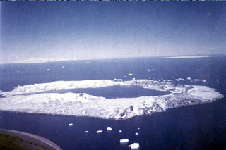
Geological Summary. Ring-shaped Deception Island, at the SW end of the South Shetland Islands, NE of Graham Land Peninsula, was constructed along the axis of the Bransfield Rift spreading center. A narrow passageway named Neptunes Bellows provides an entrance to a natural harbor within the 8.5 x 10 km caldera that was utilized as an Antarctic whaling station. Numerous vents along ring fractures circling the low 14-km-wide island have been reported active for more than 200 years. Maars line the shores of 190-m-deep Port Foster caldera bay. Among the largest of these maars is 1-km-wide Whalers Bay, at the entrance to the harbor. Eruptions during the past 8,700 years have been dated from ash layers in lake sediments on the Antarctic Peninsula and neighboring islands.
Information Contacts: A. Garcia, M. Astiz, and M. T. Villeguas, Depto. Volcanolog¡a, Museo Nacional de Ciencias Naturales, C.S.I.C. José Gutierrez Abascal 2, 28006 Madrid, Spain; J.M. Ibañez, J. Norales, and E Carmona, Instituto Andaluz de Geofísica, Apartado 2145, University of Granada, Granada, Spain; A. Caselli, G. Badi, and A. Baraldo, Instituo Antártico Argentino, Cerrito 1248, Buenos Aires, Argentina.