Report on Kama'ehuakanaloa (United States) — September 1997
Bulletin of the Global Volcanism Network, vol. 22, no. 9 (September 1997)
Managing Editor: Richard Wunderman.
Kama'ehuakanaloa (United States) 200°C fluids; radiometric ages for lavas erupted just prior to the 1996 seismic swarm
Please cite this report as:
Global Volcanism Program, 1997. Report on Kama'ehuakanaloa (United States) (Wunderman, R., ed.). Bulletin of the Global Volcanism Network, 22:9. Smithsonian Institution. https://doi.org/10.5479/si.GVP.BGVN199709-332000
Kama'ehuakanaloa
United States
18.92°N, 155.27°W; summit elev. -975 m
All times are local (unless otherwise noted)
The following report summarizes a series of Lōʻihi updates provided by the Hawaii Center for Volcanology. The largest swarm of earthquakes ever recorded at the Hawaiian volcanoes occurred below Lōʻihi Seamount during July-August 1996. Pele's Pit, a new pit crater, was detected during scientific dives after the seismic events. Pele's Pit formed at the site of Pele's Vents, a preexisting hydrothermal vent field. The events of July-August 1996 are detailed in BGVN 21:07 and 21:09.
Report of 1-30 November 1996. Radiometric dating was undertaken using the 210Po-210Pb technique, a process with a 138.4-day half-life, on two fresh lavas collected after the August 1996 seismic event; early results showed that the lavas were of different ages, but both predate the swarm event by 1-10 weeks. A later report of final results indicated that the lavas were erupted in February-March and May-June 1996. A separate set of geochemical analyses were conducted on rocks and sediments from a young breccia deposit on the W flank of Lōʻihi's summit; preliminary geochemical and petrological analysis suggests that magma was stored at a depth of ~10 km before being mixed with a more mafic magma. This mixing of two magmas may have triggered the eruption.
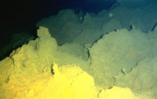
Observations of the seamount included a thin coating of hydrothermal sulfides detected at vent site 5 in Pele's Pit and abundant sedimentary deposits of black sand in the summit region and along some sections of Lōʻihi's S rift. The presence of bubble glass fragments indicated that some past eruptions were more violent than previously thought. Formation of ground cracks and fissures on the S rift at 1,300-1,400 m depth occurred at the time of the collapse of the summit pit. The fissures crosscut a previously unknown low-temperature hydrothermal vent field. The lack of temperature anomalies deeper than the new vent field and the small volume of the pit (~0.05-0.15 km3) suggest that the summit collapse was caused by magma intrusion into the upper part of the S rift, but that no eruption ensued.
Reports of early-mid and August-October 1997. The seamount was relatively quiet from late 1996 through mid-1997. No new major seismic activity occurred since August 1996.
During August and September 1997, manned submersible exploration revealed high-temperature hydrothermal fluids issuing from vents in Pele's Pit and water temperatures up to 200°C. High-temperature hydrothermal mineral deposits similar to those documented on mid-ocean ridge volcanoes were also observed; these did not resemble lower temperature materials previously found at Lōʻihi. Widespread deposits of young-looking volcanic sand were reported on the summit.
During the initial deployment of the Hawaii Undersea Geo Observatory (HUGO) in the second week of October, noises that could be interpreted as eruption-related were recorded by a hydrophone. The noises were intense and thunder-like but were not accompanied by elevated seismic activity.
Geological Summary. The Kama’ehuakanaloa seamount, previously known as Loihi, lies about 35 km off the SE coast of the island of Hawaii. This youngest volcano of the Hawaiian chain has an elongated morphology dominated by two curving rift zones extending north and south of the summit. The summit region contains a caldera about 3 x 4 km and exhibits numerous lava cones, the highest of which is about 975 m below the ocean surface. The summit platform also includes two well-defined pit craters, sediment-free glassy lava, and low-temperature hydrothermal venting. An arcuate chain of small cones on the western edge of the summit extends north and south of the pit craters and merges into the crests prominent rift zones. Seismicity indicates a magmatic system distinct from that of Kilauea. During 1996 a new pit crater formed at the summit, and lava flows were erupted. Continued volcanism is expected to eventually build a new island; time estimates for the summit to reach the ocean surface range from roughly 10,000 to 100,000 years.
Information Contacts: K. H. Rubin; Lester Sacks, Khal Spencer, Kevin Johnson, Mike Garcia, Marc Norman, and J.M. Rhodes, Hawaii Center for Volcanology, Department of Geology & Geophysics, University of Hawaii at Manoa, 2525 Correa Road, Honolulu, HI 96822 USA (URL: http://www.soest.hawaii.edu/GG/hcv.html); David Clague, Monterey Bay Aquarium Research Institute, P.O. Box 628, Moss Landing, CA 95039 USA.