Report on Villarrica (Chile) — October 1997

Bulletin of the Global Volcanism Network, vol. 22, no. 10 (October 1997)
Managing Editor: Richard Wunderman.
Villarrica (Chile) Earthquake swarm in late October
Please cite this report as:
Global Volcanism Program, 1997. Report on Villarrica (Chile) (Wunderman, R., ed.). Bulletin of the Global Volcanism Network, 22:10. Smithsonian Institution. https://doi.org/10.5479/si.GVP.BGVN199710-357120
Villarrica
Chile
39.42°S, 71.93°W; summit elev. 2847 m
All times are local (unless otherwise noted)
During March-August 1997 seismic activity at Villarrica included 1.5-2.7 Hz tremor and isolated long- period (LP) events associated with phreatic explosions. The latter are common occurrences that have taken place in previous years. Such intervals of elevated seismicity correspond with increased volcanic activity and often include larger amplitude LP earthquake swarms. Although during several days in mid- to late-May 1997 the amplitudes rose to about 20 Real-time Seismic Amplitude Measurement (RSAM) units, around 7 September they reached up to 40 RSAM units and on many days of the month peaks were above 20 RSAM units. Strombolian explosions and night glow were observed between April and August (BGVN 22:08).
Lasting at least eight days, an earthquake swarm during 20-28 October produced RSAM amplitudes an order of magnitude larger than previous months, to >200 units (figure 8). Researchers proposed that October- December swarms may have some seasonal influence associated with higher temperatures in the summer.
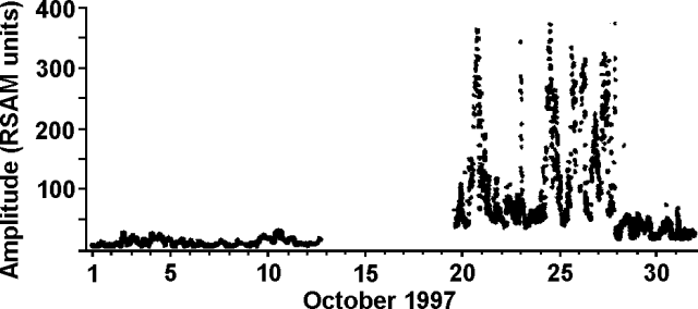 |
Figure 8. Seismic activity at Villarrica during October 1997. The system at the observatory is triaxial with a 1-second period; it was inoperative during mid-October. Courtesy of the Seismological Team, Observatorio Volcanológico de los Andes del Sur (OVDAS). |
Geological Summary. The glacier-covered Villarrica stratovolcano, in the northern Lakes District of central Chile, is ~15 km south of the city of Pucon. A 2-km-wide caldera that formed about 3,500 years ago is located at the base of the presently active, dominantly basaltic to basaltic andesite cone at the NW margin of a 6-km-wide Pleistocene caldera. More than 30 scoria cones and fissure vents are present on the flanks. Plinian eruptions and pyroclastic flows that have extended up to 20 km from the volcano were produced during the Holocene. Lava flows up to 18 km long have issued from summit and flank vents. Eruptions documented since 1558 CE have consisted largely of mild-to-moderate explosive activity with occasional lava effusion. Glaciers cover 40 km2 of the volcano, and lahars have damaged towns on its flanks.
Information Contacts: Gustavo Fuentealba C. and Paola Peña S., Seismological Team, Programa Riesgo Volcánico de Chile (PRV), Observatorio Volcanológico de los Andes del Sur, Departamento Ciencias Fisicas, Universidad de la Frontera, Avda. Francisco Salazar 01145, Casilla 54-D, Temuco, Chile.