Report on Piton de la Fournaise (France) — March 1998

Bulletin of the Global Volcanism Network, vol. 23, no. 3 (March 1998)
Managing Editor: Richard Wunderman.
Piton de la Fournaise (France) Geophysical portrayal of the March fissure eruptions
Please cite this report as:
Global Volcanism Program, 1998. Report on Piton de la Fournaise (France) (Wunderman, R., ed.). Bulletin of the Global Volcanism Network, 23:3. Smithsonian Institution. https://doi.org/10.5479/si.GVP.BGVN199803-233020
Piton de la Fournaise
France
21.244°S, 55.708°E; summit elev. 2632 m
All times are local (unless otherwise noted)
The following is a summary of observations from scientists at the Observatoire du Piton de la Fournaise and Observatoires Volcanologiques (OVPF), Institut de Physique du Globe de Paris, and the Laboratoire des Sciences de la Terre, Université de la Réunion.
Narrative. An eruption broke out on Piton de la Fournaise (PdF) at 1505 on 9 March 1998, after an unusually long period of 63 months rest. PdF (figure 41) had an average eruption rate of more than one per year in the last several decades. For a time three fissure vents were simultaneously active. The eruption continued at one fissure vent (Piton Kapor) at least as late as 20 April 1998.
 |
Figure 41. Schematic map of Piton de la Fournaise showing the 9 and 11-12 March vents, newly named scoria cones and related features, and the extent of lava flows as of 15 March. Courtesy of Thomas Staudacher, OVPF. |
Following escalating seismicity seen over the past two years, a seismic swarm developed at 0338 on 9 March (figures 42, 43, 44, and 45). The swarm was under the edifice, centered slightly W of the small Bory crater, a feature that lies immediately W of the larger Dolomieu crater. In the first observation of its kind at PdF, hypocenters progressed towards the surface prior to the eruption (figure 44).
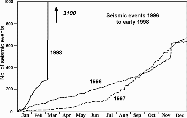 |
Figure 42. The number of seismic events accumulated annually at Piton de la Fournaise during 1996, 1997, and early 1998 (three separate curves). The seismic swarm at the end of November 1996 was not followed by an eruption. A significant change in the earthquake rate started in July 1997 and accelerated in early 1998. Courtesy of OVPF. |
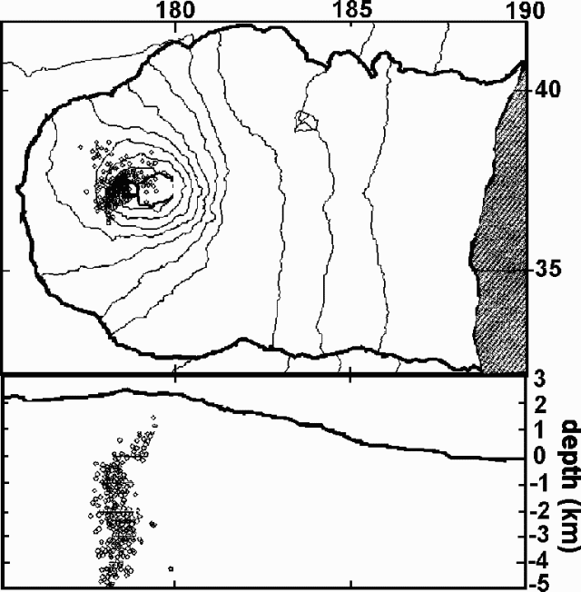 |
Figure 43. Located earthquakes at Piton de la Fournaise from 1957 on 6 March through 1857 on 10 March (top) and a vertical, E-W cross section showing hypocenters from 0000 on 8 March through 1200 on 9 March (bottom). Coordinates (labeled tic marks) for horizontal distances on the map and cross section are 5 km apart; this scale differs from the vertical scale on the cross section. Courtesy of OVPF. |
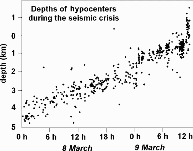 |
Figure 44. During the seismic crisis on PdF hypocenters migrated upward during the pre-eruptive 36-hour period shown (0000 on 6 March-1200 on 9 March). This was the first observation of its kind at PdF; pre-eruptive seismicity had usually remained diffusely distributed within the whole edifice. Courtesy of Jean Battaglia and Nelly Rousseau, OVPF. |
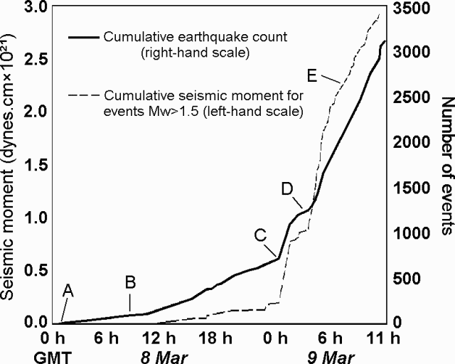 |
Figure 45. Pre-eruptive earthquake counts at Piton de la Fournaise and seismic moments for 8-9 March 1998 (times are GMT). Noteworthy points are labeled as follows: at A, focal depths of the volcano-tectonic events started at ~5 km below sea-level; at B they reached 3 km; at C, 2 km; and at D, 1 km. At E, there occurred the first long-period (near 1 Hz) event since 1993. Venting started at 1505 (1105 GMT). Courtesy of OVPF. |
The summit deformed rapidly beginning around 1400. An example of clear and sudden inflation appears in figure 46, documenting changes in radial and tangential inflation at station "Bory." Another multi-component station ("Soufriere"; immediately N of Dolomieu crater) underwent similarly rapid, though larger amplitude, displacement beginning at 1410 and peaking at 1424 to 1429 (undergoing up to 200 µrad of tilt). Inflation at Soufriere station indicated migration of magma towards the N eruptive fissures. Surface venting started there at 1505.
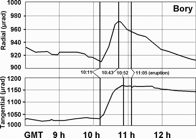 |
Figure 46. Ground deformation at the summit of Piton de la Fournaise on 9 March during 1200-1700 (0800-1300 GMT). Surface venting began at 1505 (1105 GMT). The Bory two-component inclinometer, ~200 m S of Bory crater, measures tilt aligned radial and tangential to the volcano. The rapid inflation at 1011 GMT was linked to near-surface dike emplacement. Contact the authors for collateral inclinometer and extensometer data at other summit stations. Courtesy of OVPF. |
EDM and GPS measurements showed concordant displacements at points around the summit (figures 47 and 48). The time-sequence of EDM data indicated that essentially all deformation occurred at the time of eruption. Consistent with the deformation, eruptive fissures developed between the reflectors to the NE and NW of the summit.
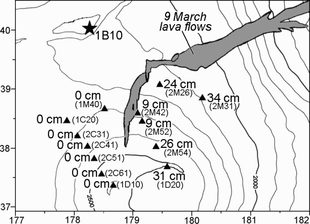 |
Figure 47. Automated electronic distance meter (EDM) measurements at Piton de la Fournaise taken from an instrument on the NW rim of the Enclos Fouqué caldera (star, labeled 1B10). The EDM computed distances and azimuths to 13 reflectors (triangles) on the flanks of the terminal cone. The numbers indicate centimeters of total displacement between 1000 and 1400 GMT on 9 March. Weather permitting, these measurements were made every hour and telemetered to the observatory in near real-time. Only reflectors E of the fissures underwent measurable relative motion, moving E up to 34 cm. Courtesy of OVPF. |
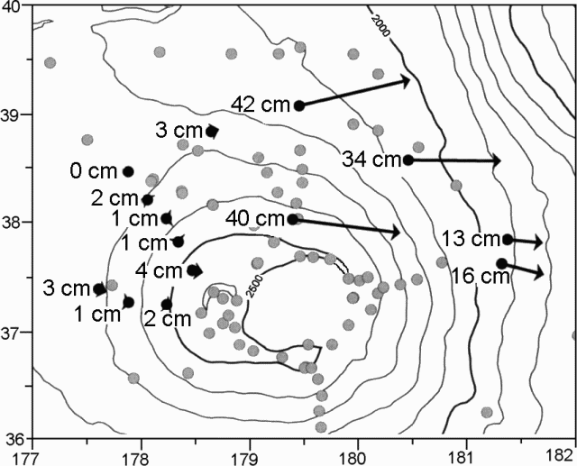 |
Figure 48. GPS measurements at Piton de la Fournaise showing horizontal displacements in centimeters from GPS positioning in November 1997 and 15 March 1998. Courtesy of OVPF. |
At 1505 on 9 March tilt on the northern summit inclinometer reversed and seismic tremor commenced, indicating the final stages of dyke emplacement and the onset of venting. Although at the time, bad weather impaired visual observation, venting was recognized, starting on a 150-m-long N-S fissure around 2,450 m elevation on the N flank of the terminal cone (figure 41). The fissure system quickly developed in an en echelon pattern stretching downslope to approximately 2,100 m elevation. Major venting migrated to the fissure's lower stretches where lava fountaining up to 50 m high fed a flow that descended E (towards an area of the N caldera called the Plaine des Osmondes). Vigorous venting continued through the night of 9 March.
A few discrete seismic events were observed through the tremor during the next two days (10-11 March). The approximate locations of the events were SW of Bory crater. During 10-11 March venting continued in the N along two 100-m-long fissures. At the time, scientists lacked visual observations of the flow front due to cloud cover. Earthquakes at Piton de la Fournaise generally cease after an eruption has broken out, but in this case they continued, hence the impending opening of a new eruption fissure was forecast for the next few hours or days.
In accord with this forecast, during the night of 11 March until 0245 the next morning, a new, isolated eruptive fissure opened WSW of the Bory crater. The vent established itself S of the other erupting fissures, at ~2,200 m elevation (figure 41). Although lava escaped at a much lower rate here than along the northern vents, this southern fissure emitted lava along a zone ~100 m in length. Fountaining lava reached ~10 m high and fed a flow that by 0800 on 11 March had traveled 200-300 m downslope.
During the following days, eruptions continued at both the two northern fissures as well as the southern fissure. Estimated emission rates on the N were 30-50 m3/s and on the S at 5-10 m3/s. Issuing from the northern fissures, E-traveling lava descended to ~1,100 m elevation by 15 March. Here, ~4 km away from the vents, the flow front became stationary. Around the same time, lava issuing at the southern fissure reached an estimated length of 1,500 m. Maximum lava temperatures reached 1,167°C at the northern vents and 1,157°C at the southern vent.
Venting was progressively restricted to limited stretches of the three fissures where scoria cones started to grow. By 19 March the scoria cones were ~40 m high and 120 m long at the upper-elevation northern site, ~35 m high at the lower-elevation northern site, and 15 m high at the southwestern site.
Features at these cones were designated as the Maurice and Katia Krafft crater, Piton Kapor, and the Fred Hudson crater (figure 41). Activity at the three cones continued, but progressively decreased until venting was restricted to Piton Kapor by 31 March. Piton Kapor was still quite active as of 20 April 1998.
Preliminary petrography indicated that the lavas were mostly aphyric basalts carrying a small but variable number of millimeter-sized olivine crystals. Under the assumption that their composition lay close to the so-called "stationary basalts," modeling indicated that they vented at temperatures close to their liquidus.
Premonitory geophysical observations. Clear-cut long-term observations on the various surveillance networks that signaled an impending eruption were, as is customary at PdF, discrete and few. Increasing seismicity late in 1997 and accelerating in early 1998 were signs that an abnormal situation was developing. However, other crises, albeit of smaller intensities, occurred in November 1996 and July 1997 and did not result in an eruption. Small perturbations were seen on the deformation (inclinometry, geodesy, and extensometry) networks months before the present event but were not interpreted as premonitory. These signs most probably corresponded to magma intrusions within the edifice.
Surveillance network observations. It was only a few hours before the 9 March outbreak that short-term signs definitely signaled an impending eruption and civil authorities were warned of a maximum alert. Critical signs included seismic, tilt, and deformation data (summarized on figures 42 to 48). In addition, a total-field magnetometer network provided clear pre- and syn-eruptive signals that remain under interpretation. Measurements on about 50 of the approximately 100 microgravity-benchmark and GPS-array stations were repeated between 18 and 31 March with two Scintrex CG-3M gravimeters. The array was last surveyed in December 1997. A few stations showed variations of relatively small amplitude. Interpretations must await correction of the elevation changes and comparison with the recordings provided by the two permanent monitoring stations installed in December 1997. Radon stations did not show any unusual pattern either before or during the first stages of the outbreak as was hoped from previous behavior during intrusive events (BGVN 21:12).
The Observatoire Volcanologique du Piton de la Fournaise(OVPF) was built in 1979 after the devastation of the 1977 eruption owing to the financial help of the Institut National des Siences de l'Univers, France. The Observatory became operational in 1980; since then, tens of eruption have been closely observed and, most often, forecast sufficiently in advance to alleviate possible personal and material damages.
Besides the information contacts listed below, report contributors also included Kei Aki, Valérie Ferazzini, Louis-Philippe Ricard, Nelly Rousseau, Jean Battaglia, Nicolas Villeneuve, Philippe Kowalski, Philippe Catherine, Denis Wégerlé, Grégory Durand, Nadia Talibart, Jacques Lebreton, Maolidi Assoumani, Massimo Bonfiglio, Bernard Robineau, Jean-Lambert Join, Eric Delcher, Jean-Luc Folio, Jean-Luc Hoareau, Cécile Savin, Hamidou Nassor, Evelyn Maillot, Jean-Claude Lépine, Martine Hirn-Sapin, Christine Deplus, Pierre Briole, Sylvain Bonvalot, Jacques Zlotnicki, Germinal Gabalda, Philippe Labazuy, Alfred Hirn, Jean-Claude Delmond, Guy Aubert, Michel Diament, and Janine Gouin.
Geological Summary. Piton de la Fournaise is a massive basaltic shield volcano on the French island of Réunion in the western Indian Ocean. Much of its more than 530,000-year history overlapped with eruptions of the deeply dissected Piton des Neiges shield volcano to the NW. Three scarps formed at about 250,000, 65,000, and less than 5,000 years ago by progressive eastward slumping, leaving caldera-sized embayments open to the E and SE. Numerous pyroclastic cones are present on the floor of the scarps and their outer flanks. Most recorded eruptions have originated from the summit and flanks of Dolomieu, a 400-m-high lava shield that has grown within the youngest scarp, which is about 9 km wide and about 13 km from the western wall to the ocean on the E side. More than 150 eruptions, most of which have produced fluid basaltic lava flows, have occurred since the 17th century. Only six eruptions, in 1708, 1774, 1776, 1800, 1977, and 1986, have originated from fissures outside the scarps.
Information Contacts: Thomas Staudacher, Observatoire Volcanologique du Piton de la Fournaise (OVPF), 14 RN3, le 27Km, 97418 La Plaine des Cafres, La Réunion, France; Patrick Bachèlery, Département des Sciences de la Terre, Université de la Réunion, BP 7151, 15 Avenue Rene Cassin, 97715 Saint Denis Cedex 9, La Réunion, France; Michel P. Semet and Jean-Louis Cheminée, Observatoires Volcanologiques, Institut de Physique du Globe de Paris, 4 Place Jussieu, 75252 Paris Cedex 05, France (URL: http://www.ipgp.jussieu.fr/).