Report on Irazu (Costa Rica) — March 1998
Bulletin of the Global Volcanism Network, vol. 23, no. 3 (March 1998)
Managing Editor: Richard Wunderman.
Irazu (Costa Rica) The 26-27 December seismic swarm 20 km from summit (220 earthquakes)
Please cite this report as:
Global Volcanism Program, 1998. Report on Irazu (Costa Rica) (Wunderman, R., ed.). Bulletin of the Global Volcanism Network, 23:3. Smithsonian Institution. https://doi.org/10.5479/si.GVP.BGVN199803-345060
Irazu
Costa Rica
9.979°N, 83.852°W; summit elev. 3436 m
All times are local (unless otherwise noted)
During 26-27 December a small seismic swarm at Irazú consisted of 220 earthquakes. At the swarm's peak 109 earthquakes occurred in 15 hours. The epicenters fell 20 km NNW of the summit, originating on a local fault. The largest earthquake, at 0154 on 27 December, was M 2.9. It had a focal depth of 5 km and an epicenter 20 km NW of the summit. For comparison, during the months of January, February, and March 1998, the respective counts consisted of 58, 59, and 70 local earthquakes.
During 20 and 22 February seven earthquakes took place, including one of M 2.3 and another of M 1.8. Both of these events had epicenters within 7 km of the summit; their respective focal depths were at 8 km and 1 km.
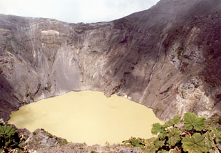
During January the lake in the active crater remained greenish yellow and lacked bubbling along its shores. These areas were not mentioned as active again during February-March, although the lake's color was later described as light green. The monthly fluctuations in lake level noted for December to March were under a meter. During early 1998 small landslides continued to occur along the crater's N, E, and W walls. During February, fumaroles remained active on the volcano's NW flanks; their visible outputs remained moderate and their temperatures measured 91°C.
Geological Summary. The massive Irazú volcano in Costa Rica, immediately E of the capital city of San José, covers an area of 500 km2 and is vegetated to within a few hundred meters of its broad summit crater complex. At least 10 satellitic cones are located on its S flank. No lava effusion is known since the eruption of the Cervantes lava flows from S-flank vents about 14,000 years ago, and all known Holocene eruptions have been explosive. The focus of eruptions at the summit crater complex has migrated to the W towards the main crater, which contains a small lake. The first well-documented eruption occurred in 1723, and frequent explosive eruptions have occurred since. Ashfall from the last major eruption during 1963-65 caused significant disruption to San José and surrounding areas. Phreatic activity reported in 1994 may have been a landslide event from the fumarolic area on the NW summit (Fallas et al., 2018).
Information Contacts: E. Fernandez, V. Barboza, R. Van der Laat, R. Saenz, E. Duarte, E. Malavassi, T. Marino, M. Martinez, and E. Hernandez, Observatorio Vulcanologico y Sismologico de Costa Rica, Universidad Nacional (OVSICORI-UNA), Apartado 86-3000, Heredia, Costa Rica; Mauricio Mora Fernandez, Sección de Sismologia, Vulcanologia y Exploración Geofisica, Escuela Centroamericana de Geología, Universidad de Costa Rica, P.O. Box 35-2060, San José, Costa Rica.

