Report on Guagua Pichincha (Ecuador) — March 1998

Bulletin of the Global Volcanism Network, vol. 23, no. 3 (March 1998)
Managing Editor: Richard Wunderman.
Guagua Pichincha (Ecuador) Series of phreatic explosions during 1997
Please cite this report as:
Global Volcanism Program, 1998. Report on Guagua Pichincha (Ecuador) (Wunderman, R., ed.). Bulletin of the Global Volcanism Network, 23:3. Smithsonian Institution. https://doi.org/10.5479/si.GVP.BGVN199803-352020
Guagua Pichincha
Ecuador
0.171°S, 78.598°W; summit elev. 4784 m
All times are local (unless otherwise noted)
During March-October 1997 a series of phreatic explosions took place within Guagua Pichincha's caldera (figure 5). No precursory signals were detected prior to the activity. The intensity of these explosions peaked in May 1997; the last explosive signal was detected on 18 October 1997. This activity resembled phreatic explosions that occurred in 1981, 1990, and 1993.
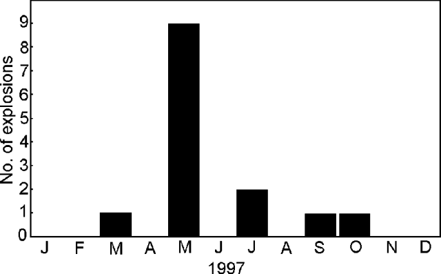 |
Figure 5. Monthly counts of explosion signals at Guagua Pichincha detected by Instituto Geofisico seismic stations during 1997. Courtesy of the Instituto Geofisico. |
Larger explosions on 15, 16, 18, 20, and 22 May, 22 and 23 July, and 18 October were detected by four short-period seismic stations located around the volcano. Tremor signals following these explosions had reduced displacements of 2. The largest explosion occurred on 29 May at 0654; its signal was recorded at eight sites, including seismic stations at the volcanoes Cotopaxi (58 km away), Cotacachi (60 km away), and Cayambe (70 km away). The accompanying tremor signal had a reduced displacement of 8.9 cm2. An A-type fracture event located just outside the E caldera rim at 3 km depth preceded the explosion.
Following the 20 May explosion, volcanologists observed two new, white, 250-m-tall fumarolic plumes rising from the explosion crater. The crater showed evidence of recent collapses on its interior S and SW sides. Fine pulverized rock deposits covered more than 2 km2 in the N part of the caldera bottom. Blocks up to 50 cm across were scattered over the caldera floor as far as 1 km from the crater; impact craters up to 2 m in diameter were formed. No juvenile material was found.
During 1997, the number of events at stations close to the caldera remained at normal values except during September-October, when a large number of events were detected at stations 1.0-1.2 km from the crater. However, at stations over 10 km away, the number of events remained at normal values. Low seismicity preceded phreatic activity in 1990 and 1993. The hypocenter locations of high-frequency events were at depths <5 km beneath the caldera floor (figure 6).
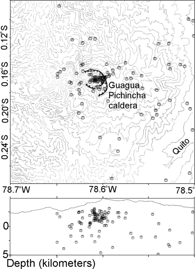 |
Figure 6. Epicenter map (top) and E-W cross-section (bottom) of high-frequency events at Guagua Pichincha during 1997. Courtesy of Instituto Geofisico. |
A swarm of 26 local earthquakes (M <3) lasted less than 1 hour on 16 December 1997. This was the first such swarm detected at Guagua Pichincha since continuous seismic monitoring began in 1981. EDM deformation monitoring of the phreatic crater and outer flanks of the dome revealed no change with regard to the baseline established in 1988.
Thermocouple measurements of fumarole temperatures on the dome showed values of 120-120.7°C, the same as during prior measurements in 1995, but lower than those detected in February 1994 (138-139°C). Prior to 1994, fumarole temperatures were constant at 87°C. Analyses of spring water from the caldera and the surrounding area gave essentially the same results as in 1988.
Geological Summary. Guagua Pichincha and the older Pleistocene Rucu Pichincha stratovolcanoes form a broad volcanic massif that rises immediately W of Ecuador's capital city, Quito. A lava dome grew at the head of a 6-km-wide scarp formed during a late-Pleistocene slope failure ~50,000 years ago. Subsequent late-Pleistocene and Holocene eruptions from the central vent consisted of explosive activity with pyroclastic flows accompanied by periodic growth and destruction of the lava dome. Many minor eruptions have been recorded since the mid-1500's; the largest took place in 1660, when ash fell over a 1,000 km radius and accumulated to 30 cm depth in Quito. Pyroclastic flows and surges also occurred, primarily to then W, and affected agricultural activity.
Information Contacts: Mario Ruiz Romero, Instituto Geofísico de la Escuela Politécnica Nacional.