Report on Iwatesan (Japan) — April 1998
Bulletin of the Global Volcanism Network, vol. 23, no. 4 (April 1998)
Managing Editor: Richard Wunderman.
Iwatesan (Japan) Rising earthquake counts during January-May
Please cite this report as:
Global Volcanism Program, 1998. Report on Iwatesan (Japan) (Wunderman, R., ed.). Bulletin of the Global Volcanism Network, 23:4. Smithsonian Institution. https://doi.org/10.5479/si.GVP.BGVN199804-283240
Iwatesan
Japan
39.853°N, 141.001°E; summit elev. 2038 m
All times are local (unless otherwise noted)
According to the Japan Meteorological Agency (JMA), high seismicity (figure 1) and strong deformation began at Iwate in March and remained high in early May. In the first week of May, 30-80 volcanic earthquakes registered per day at the Matsukawa observation site (5 km NW of the summit). Rising monthly earthquake totals during January-May are listed in table 1. On 29 April, 285 earthquakes occurred; the strongest recorded was M 2.7. Tiltmeter and volumetric strain meters disclosed large changes at around 1500. On 7 May, a M 3.3 earthquake occurred at 0300.
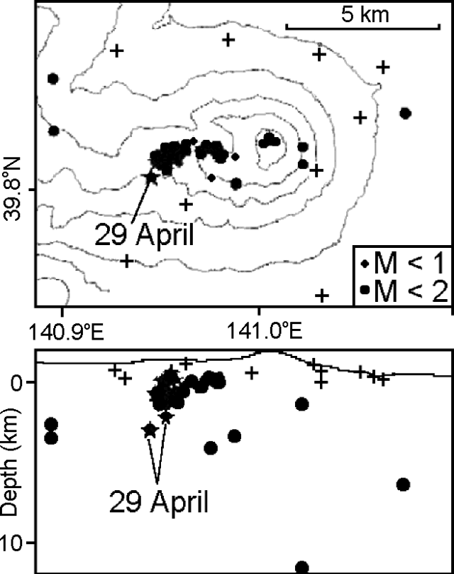 |
Figure 1. Map view of volcanic earthquake locations at Iwate during 27 March-29 April (top) and a W-E cross-section showing earthquake depths (bottom). Tohoku University's instrument observation sites (crosses) are projected onto the line of cross section, explaining why some appear to lie in the subsurface. Courtesy of Tohoku University. |
Table 1. Monthly earthquake counts at Iwate during January-May 1998. Courtesy of JMA.
| Month | Earthquakes |
| Jan 1998 | 22 |
| Feb 1998 | 68 |
| Mar 1998 | 424 |
| Apr 1998 | 764 |
| May 1998 (as of 1600 on 7 May) | 364 |
A GPS survey revealed N-S extension of the volcanic cone during February-May. The 29-km line between two observation sites N and S of the summit began to extend in February; the rate of movement accelerated in late April. By early May, the extension totaled 2 cm. A 1 May air survey revealed no anomalies on or around the summit area.
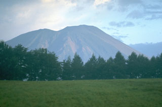
Geological Summary. Viewed from the east, Iwatesan volcano has a symmetrical profile that invites comparison with Fuji, but on the west an older cone is visible containing an oval-shaped, 1.8 x 3 km caldera. After the growth of Nishi-Iwate volcano beginning about 700,000 years ago, activity migrated eastward to form Higashi-Iwate volcano. Iwate has collapsed seven times during the past 230,000 years, most recently between 739 and 1615 CE. The dominantly basaltic summit cone of Higashi-Iwate volcano, Yakushidake, is truncated by a 500-m-wide crater. It rises well above and buries the eastern rim of the caldera, which is breached by a narrow gorge on the NW. A central cone containing a 500-m-wide crater partially filled by a lake is located in the center of the oval-shaped caldera. A young lava flow from Yakushidake descended into the caldera, and a fresh-looking lava flow from the 1732 eruption traveled down the NE flank.
Information Contacts: Volcanological Division, Seismological and Volcanological Department, 1-3-4 Ote-machi, Japan Meteorological Agency (JMA), Chiyoda-ku, Tokyo 100, Japan; Volcano Research Center, Earthquake Research Institute (ERI), University of Tokyo, Yayoi 1-1-1, Bunkyo-ku, Tokyo 113, Japan; Noritake Nishide, Sendai District Meteorological Observatory, Japan Meteorological Agency, 1-3-15 Gorin, Miyagino-ku, Sendai 983, Japan; Hiroyuki Hamaguchi, Faculty of Science, Tohuku University, Sendai 980-77, Japan; Takashi Tada, Geographical Survey Institute, Tsukuba-shi, Ibaraki, Japan.