Report on Ukinrek Maars (United States) — April 1998
Bulletin of the Global Volcanism Network, vol. 23, no. 4 (April 1998)
Managing Editor: Richard Wunderman.
Ukinrek Maars (United States) Tectonic earthquake swarm in the Ukinrek Maars area
Please cite this report as:
Global Volcanism Program, 1998. Report on Ukinrek Maars (United States) (Wunderman, R., ed.). Bulletin of the Global Volcanism Network, 23:4. Smithsonian Institution. https://doi.org/10.5479/si.GVP.BGVN199804-312131
Ukinrek Maars
United States
57.8344°N, 156.5203°W; summit elev. 91 m
All times are local (unless otherwise noted)
During 8-9 May, a seismic swarm of tectonic earthquakes shook the middle Alaskan Peninsula region including the towns of King Salmon, Dillingham, Egegik, and Pilot Point. The swarm began with five earthquakes of M 5.2-4.7 occurring between 1630 and 2259. Dozens of earthquakes in the M 2.5-3.5 range were felt locally. The earthquakes continued through 9 May, but the number of earthquakes had decreased notably by the morning of 10 May. Felt earthquakes were still occurring at a rate of 1-2/day as of the afternoon of 12 May.
The earthquakes were clustered on the SW shore of Lake Becharof, approximately 10-20 km NW of the 1977 Ukinrek Maars volcanoes and near the S end of the Bruin Bay fault. The earthquakes were all very shallow (<7 km in depth). In the past, the few local seismic stations have been able to accurately locate earthquakes only of magnitudes greater than M 4. The recent expansion of Alaska Volcano Observatory (AVO) volcano seismic monitoring to include volcanoes in Katmai National Park, NE of Lake Becharof, and Aniakchak Volcano, to the SW, has allowed better detection and location of Becharof earthquakes.
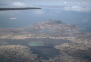
AVO scientists traveled to King Salmon on 9 May for an overflight of the swarm location and vicinity. Their U.S. Fish and Wildlife Service (FWS) pilot had overflown the area the evening of 8 May after the first earthquakes. Nothing indicating any volcanic activity or surface breakage was seen on either flight. Some small slumping was noticed along the SW shoreline of Lake Becharof and some local discoloration by sediments was seen both likely resulting from ground shaking. Similarly, a slight change in the green coloration of the crater lake in the large maar at Ukinrek Maars was likely due to disturbed sediments. No evidence of any disturbance or unusual activity was seen at Peulik volcano. Peulik is heavily snow-covered and showed no sign of discoloration, deformation, or slumping. The area of seismicity is not monitored by real-time seismic instrumentation; scientists scouted for possible locations to establish a temporary seismic net. The net will allow scientists to determine if there is a volcanic component to the earthquake swarm and any potential volcanic hazard. AVO is also in communication with citizens of King Salmon, Egegik, Meshik, and Pilot Point, as well as the National Park Service and FWS pilots who frequently overfly the area.
The preliminary interpretation is that the swarm was of tectonic origin, although the occurrence of five M 4.7-5.2 earthquakes in such a short time with no clear mainshock may suggest a volcanic component. Considering the nature of the formation of Ukinrek Maars in 1977, where no volcano existed previously, intrusion of magma associated with tectonic movement is possible. There is no evidence of imminent volcanic hazard from this seismic swarm.
Background. The May 1998 swarm was the most energetic to date. There were no major seismic events detected in association with the 1977 Ukinrek Maars eruptions, except for a number of small events detected by a portable seismic net which was deployed by the University of Alaska at Fairbanks (UAF) and the U.S. Geological Survey (USGS) for several months following the 1977 eruptions. Ukinrek Maars formed 30 March-10 April, 1977 as a result of magmatic intrusion into water-saturated glacial till 2 km S of Gas Rocks on the S shore of Lake Becharof. During a 10-day period, violent explosions produced steam and ash plumes as high as 6.5 km and light ash fall as far as 160 km to the N. Since the Ukinrek Maars formed, CO2 gas has been continuously emitted from the vicinity of the maars, the Gas Rocks, and from beneath Lake Becharof.
Geological Summary. Ukinrek Maars are two explosion craters that were created in an area without previous volcanic activity during a 10-day phreatomagmatic eruption March-April 1977. The basaltic maars were erupted through glacial deposits in the Bering Sea lowlands 1.5 km S of Becharof Lake and 12 km W of Peulik volcano; their location is related to the regional Bruin Bay fault. The elliptical West Maar, which was the first to form, is 105 x 170 m and 35 m deep. The other maar, 600 m to the east, is 300 m wide and 70 m deep. Both maars are now filled by crater lakes; the eastern lake encircles a 49-m-high lava dome that was emplaced at the end of the eruption. Base surges were directed primarily to the NW. Juvenile material from the Ukinrek eruptions was of mantle-derived olivine basaltic composition. The dacitic Gas Rocks lava domes, of Quaternary age, are located on the shores of Becharof Lake, 3 km N of Ukinrek maars and were the site of a phreatic eruption about 2,300 years ago.
Information Contacts: Alaska Volcano Observatory (AVO), a cooperative program of a) U.S. Geological Survey, 4200 University Drive, Anchorage, AK 99508-4667, USA (URL: http://www.avo.alaska.edu/), b) Geophysical Institute, University of Alaska, PO Box 757320, Fairbanks, AK 99775-7320, USA, and c) Alaska Division of Geological & Geophysical Surveys, 794 University Ave., Suite 200, Fairbanks, AK 99709, USA; Roger Hansen, Geophysical Institute, University of Alaska, PO Box 757320, Fairbanks, AK 99775 USA.