Report on Arenal (Costa Rica) — April 1998

Bulletin of the Global Volcanism Network, vol. 23, no. 4 (April 1998)
Managing Editor: Richard Wunderman.
Arenal (Costa Rica) Unusually energetic eruption on 5 May sends pyroclastic flows 2 km downslope
Please cite this report as:
Global Volcanism Program, 1998. Report on Arenal (Costa Rica) (Wunderman, R., ed.). Bulletin of the Global Volcanism Network, 23:4. Smithsonian Institution. https://doi.org/10.5479/si.GVP.BGVN199804-345033
Arenal
Costa Rica
10.463°N, 84.703°W; summit elev. 1670 m
All times are local (unless otherwise noted)
In the early afternoon of 5 May, Arenal, which typically issues Strombolian eruptions and lava flows, began discharging pyroclastic flows. Although pyroclastic flows have been common here in the past, rarely have so many repeatedly erupted over the course of hours. What follows integrates reports from OVSICORI-UNA and OSIVAM.
OVSICORI-UNA noted that few premonitory signs were apparent during April. Compared to March, April eruptive active appeared diminished in terms of the number of eruptions, their intensity, and the quantity of ejecta. During April lava flows traveling down the W flanks stood at about 1,250- and 1,450-m elevations, the latter flow having first vented at the beginning of April. Also during April a new lava flow directed NW reached 1,200 m elevation and a lava flow descended the N flank to 1,300 m elevation.
During April blocks on Crater C's NW wall broke loose and caused small avalanches. Only fumarolic emanations came from Crater D. During nine days of April when the OVSICORI-UNA seismic system operated, 93 events were registered, most associated with Strombolian eruptions and avalanches down the W and NW flanks. Tremor prevailed during this period for 86 hours. Histograms showing recent values for monthly earthquakes and tremor appeared in BGVN 22:11.
The strongest emissions on 5 May took place during about 1300-1500. During 1254-1900 OVSICORI-UNA estimated Arenal produced 23 pyroclastic flows. These flows traveled down the NNW flank (in the upper reaches of the Tabacón drainage basin) reaching 740 m elevation (dashed arrow, figure 84). OSIVAM also reported 23 pyroclastic flows, during the interval 1220-1800, which they designated block-and-ash flows. They noted that several of these flows occurred almost continuously during the first 30 minutes, followed by others separated by several minutes (i.e., events at 1305-1317, 1420, 1427-1435, 1440, 1450, 1510, 1516, 1530, 1547, and 1600). They also noted that the pyroclastic flows began after the partial collapse of the cone's NNW wall, a spot that contained an adjacent pool of pasty, near-solidus lava. The flows had maximum run-out distances of ~2 km; they reached velocities of ~60 km/hour, and their total volume reached perhaps 500,000 m3(about one-fourth the volume of 1993 pyroclastic flows; Soto and others, 1996). Clasts within the deposits were predominantly faceted blocks. In contrast, bulbous lava lumps constituted <5% of the observed deposit. OSIVAM suggested the former had come from the crust or cap of the lava pool, an observation in accord with the apparent partial collapse along the margin of the lava pool.
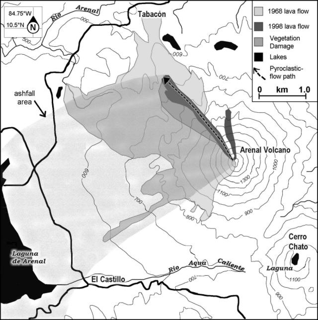 |
Figure 84. Map of Arenal and vicinity showing the situation just after the 5 May 1998 eruption. The 5 May pyroclastic flows swept NNW (dashed arrow); they burned vegetation, especially along their path's southwesterly fringe. Associated tephra fell on Arenal's W side. Courtesy of OVSICORI-UNA. |
Along the steepest pitches of the route of the pyroclastic flows (areas sloping 35-40°), they scoured a gully or channel that OVSICORI-UNA estimated had a maximum width of 100 m, a depth of ~10 m, and a length of ~1.6 km (figure 85). OSIVAM estimated the scoured channel as ~50 m in width, ~10-20 m in depth, and ~400 m in length. The feature was short-lived: during the night of 5 May new blocky lavas spilled from the source of the pyroclastic flows and began filling the channel.
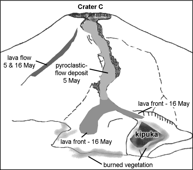 |
Figure 85. Sketch showing Arenal's NW to N flanks as seen on 6 and 16 May 1998 from Tabacón resort. Recent deposits on 6 May included the N-flank April lavas, and the 5 May pyroclastic-flow deposit with areas scorched and burned alongside it. Although not shown, by 16 May lavas covered the bulk of both the pyroclastic-flow deposit and the narrow channel scoured in the steep upper parts of the edifice; the distal ends of these lavas progressed downslope from the pyroclastic-flow deposits, forming the two branching lobes shown. One burned area seen on 6 May was a pre-existing kipuka (an area between lava flows that had continued to support vegetation). Courtesy of OVSICORI-UNA. |
OSIVAM's Fernando Alvarado witnessed the pyroclastic flows and took several dozen photographs. Inspection of these photographs suggested that some flows were relatively simple, containing a single front, and that they traveled only about 1 km. Other flows had two to three lobes moving at different velocities; they incorporated larger volumes of tephra and achieved longer runout distances.
The OSIVAM seismic system (six digital stations around Arenal) failed to detect any clear seismic event that triggered the initial collapse that led to the onset of pyroclastic flows. During the event, the seismic data disclosed small explosions, thought to be due to decompression of the lava pool during unloading.
OVSICORI-UNA reported that the pyroclastic flows left a deposit of bombs, blocks, and ash. Included blocks were semi-rounded and had abundant cooling joints; they often contained scoriaceous and bread-crust textures; their sizes ranged up to 1.5 x 3.5 x 4 m. These larger blocks appeared to float within a deposit of smaller blocks and sand-sized grains. At an undisclosed time of inspection the block's temperatures were as high as 525°C, whereas at 10-cm depth the smaller tephra of the deposit's matrix reached only 100°C.
Some vegetated areas adjacent to the pyroclastic deposits were scorched or burned (figures 84 and 85). The OVSICORI-UNA report described an older kipuka (figure 85) downslope of the terminal end of the flows, which was about 100 x 400 m across.
OVSICORI-UNA further reported that the 5 May eruption discharged ash clouds that rose to 1.5 km; portions of the ash cloud's base covered the NW, W, and SW flanks of the volcano. At 3 km from the vent, the maximum ash-fall deposit thicknesses were 2-5 mm. Ash fell on the community of Castillo, 7 km SW of Arenal and on the surface of the nearby reservoir Laguna de Arenal (figure 84). Ash plumes reached 35 km SW (Las Juntas de Abangares).
After 5 May, OVSICORI-UNA noted that emerging lava continued to follow the channel scoured by the pyroclastic flows. By 9 May lava had refilled a large part of the channel and the volcano returned to issuing more typical Strombolian eruptions. By 16 May extruded lava had filled the channel, progressed beyond its terminal end, and branched into two lobes (figure 85).
OVSICORI-UNA's Rodolfo Van der Laat noted that authorities and others responded rapidly; aviators were warned and asked to make special detours around the erupting plume. The 5 May events prompted authorities to raise the hazard status to "red alert." It turned out that the distal ends of the longest pyroclastic flows came to rest about 1.6 km from a lodge and hot-spring spa (Tabacón resort). In the Tabacón valley over 400 people were evacuated. Media reports included articles in "La Nacion" newspaper (in English by V. Murillo and G.Chaves and in Spanish by C. Hernandez and Adrian Meza). They described tourists intent on taking photos and reluctant to leave the hazardous area.
Background. Noteworthy pyroclastic flows at Arenal occurred both in 1968 (Sáenz and Melson, 1968) as well as in 1975 (Van der Bilt and others, 1975; Matumoto and Umaña, 1976), 1987, 1993 (Fernández and others, 1993, 1994), and again on 5 May 1998. Arenal's first historical eruption, in 1968, began an unbroken sequence of Strombolian explosions and basaltic andesite discharges from multiple vents. Pyroclastic flows have frequently accompanied eruptions. The 1968 explosive episode devastated the W flank and caused 78 deaths. Arenal's post-1968 Strombolian-type eruptions have produced basaltic-andesite tephra and lavas. The volcano has become a popular spot for tourists, and facilities near the volcano, including some on the now-vulnerable NW side, have recently grown in number.
References. Fernández, E., Barquero, J., Barboza, V., Van der Laat, R., Marino, T., and De Obaldía, F., 1993, Estado de los volcanes 1991: Boletín de Vulcanología, no. 22, p. 5-10.
Fernández, E., Barquero, J., Barboza, V., Van der Laat, R., Marino, T., and De Obaldía, F., 1994, Estado de los volcanes 1992: Boletín de Vulcanología, no. 23, p. 5-11.
Matumoto, T., and Umaña, J., 1976, Informe sobre la actividad del volcán Arenal ocurrida el 17 de junio de 1975: Revista Geofísica del Instituto Panamericano de Geografía e Historia 5, p. 299-315.
Sáenz, R., and Melson, W., 1968, La erupción del volcán Arenal, Costa Rica en julio de 1968, Revista Geográfica de América Central: Escuela de Geografía, Facultad de Ciencias de la Tierra y el Mar, Universidad Nacional, Heredia, Costa Rica, No. 5-6, p. 55-148.
Soto, G.J., Arias, F., Alvarado, G.E., Madrigal, L.A., and Barquero, R., 1996, Resumen de la actividad del Volcán Arenal durante 1993 (Summary of Arenal's volcanic activity during 1993): Bol. Obs. Vulc. Arenal 6 (11-12), San José, Costa Rica, p. 5-22.
Van der Bilt, H., Paniagua, S., and Avila, G., 1976, Informe sobre la actividad del volcán Arenal iniciada el 17 de junio de 1975: Revista Geofísica del Instituto Panamericano de Geografía e Historia 5, p. 295-298.
Geological Summary. Conical Volcán Arenal is the youngest stratovolcano in Costa Rica and one of its most active. The 1670-m-high andesitic volcano towers above the eastern shores of Lake Arenal, which has been enlarged by a hydroelectric project. Arenal lies along a volcanic chain that has migrated to the NW from the late-Pleistocene Los Perdidos lava domes through the Pleistocene-to-Holocene Chato volcano, which contains a 500-m-wide, lake-filled summit crater. The earliest known eruptions of Arenal took place about 7000 years ago, and it was active concurrently with Cerro Chato until the activity of Chato ended about 3500 years ago. Growth of Arenal has been characterized by periodic major explosive eruptions at several-hundred-year intervals and periods of lava effusion that armor the cone. An eruptive period that began with a major explosive eruption in 1968 ended in December 2010; continuous explosive activity accompanied by slow lava effusion and the occasional emission of pyroclastic flows characterized the eruption from vents at the summit and on the upper western flank.
Information Contacts: R. Van der Laat, E. Fernandez, F. de Obaldia, T. Marino, V. Barboza, W. Jimenez, R. Saenz, E. Duarte, M. Martinez, E. Hernandez, and F. Vega, Observatorio Vulcanologico y Sismologico de Costa Rica, Universidad Nacional (OVSICORI-UNA), Apartado 86-3000, Heredia, Costa Rica; G.J. Soto, G.E. Alvarado, and W. D. Taylor, Oficina de Sismologia y Vulcanologia del Arenal y Miravalles (OSIVAM), Instituto Costarricense de Electricidad (ICE), Apartado 10032-1000, San José, Costa Rica; La Nacion, San José, Costa Rica (URL: http://www.nacion.co.cr/ln_ee/1998/mayo/06/english3.html).