Report on Merapi (Indonesia) — August 1998

Bulletin of the Global Volcanism Network, vol. 23, no. 8 (August 1998)
Managing Editor: Richard Wunderman.
Merapi (Indonesia) Details of July eruptions, new monitoring equipment
Please cite this report as:
Global Volcanism Program, 1998. Report on Merapi (Indonesia) (Wunderman, R., ed.). Bulletin of the Global Volcanism Network, 23:8. Smithsonian Institution. https://doi.org/10.5479/si.GVP.BGVN199808-263250
Merapi
Indonesia
7.54°S, 110.446°E; summit elev. 2910 m
All times are local (unless otherwise noted)
The relative calm in seismic, gas, and rockfall activity at Merapi ended in late June (BGVN 23:07). Activity since November 1994 had been concentrated on the S of the volcano, but activity in July occurred mainly on the W slopes. Further details of the July eruptions are reported below, followed by an account of new monitoring equipment.
Changes in the measured tilt began in early June on the W flank, forecasting an increase in activity. Tilt increased at the end of June and an extension of 1 m was detected by electronic distance measurement during the first week of July. Also, the tilt measured by station ST3, located at the crater rim near the active dome, showed strong inflation at extraordinarily high rates of up to 200 µrad/hour. This high tilt rate was likely influenced by heat radiated from the new dome; an accurate estimate of tilt with this effect removed remains problematic. After the nuée ardente of 8 July, no further signals from ST3 were recorded and an early August field trip failed to find any remnants of the station.
Increases in accumulated seismic energy indicated an approaching change in the eruption regime. Soon after a small explosion on 30 June a plume emerged from the summit and a glowing avalanche rushed down the W slope. The explosion opened at least one hole on the W slope close to the summit. New lava was squeezed out of the opening "like toothpaste" without friction or pressure; the volcano seemed to be partially open. During the next week, avalanches connected to new dome building were observed from Babadan on the W slope. Based on observation of these avalanches, the nuée ardente on 8 July was expected. The daily number of rockfalls increased strongly from a few, to dozens, and then to more than 100; some rockfalls were glowing.
Seismicity (especially multi-phase events) strongly increased in early July (figure 19) before peaking on 11 July when 37 nuées ardentes occurred between midnight and 0500. The most powerful eruption that day happened at 0445; volcanic material flowed 4 km from the summit. The plume reached a height of ~4 km and ash was distributed 15-20 km away. During 11-19 July, 128 nuées ardentes were seen, including a final strong pyroclastic ash-and-block flow at 1500 on 19 July. Seismic activity, except the number of rock falls, decreased after 19 July. Four episodes of volcanic tremor were recorded in July (usually during vigorous eruptive activity), indicating magma movement. The dome grew briskly without special seismic activity, although much of the new lava collapsed, causing hundreds of daily avalanches. Many local residents watched huge glowing rockfalls at night on the W slope.
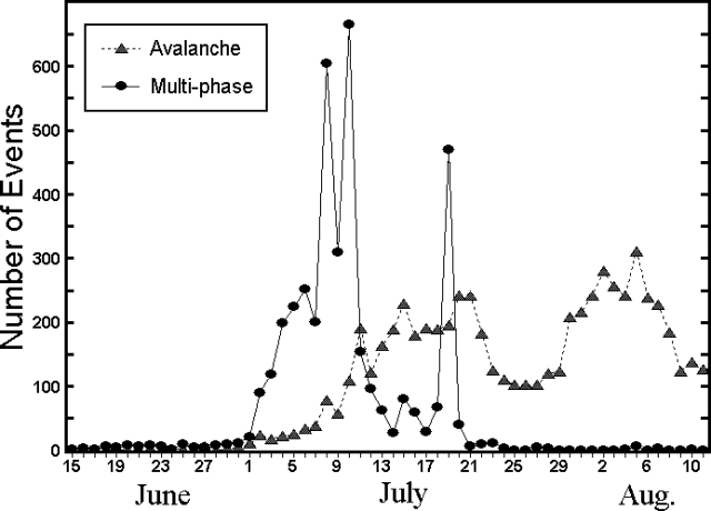 |
Figure 19. A graph of rockfall (avalanche) and multi-phase seismicity recorded at Merapi during 15 June-12 August 1998. Data courtesy of MVO. |
Explosion sounds were heard only close to the dome (for example, in Klatakan but not in Babadan). On 30 June a seismologist working on the W slope in Klatakan on an active seismic experiment heard a sharp noise at about 1130 that preceded both a plume and pyroclastic flows.
Some W-side stations were covered with more than 2.5 cm of ash. Pyroclastic-flow deposits filled parts of a valley on the W slope, almost reaching the town of Jerung Jeru, 7 km from the summit. The total amount of material erupted during July was estimated to be 8.8 x 10⁶ m3. The huge amount of ash released during July suggested an explosive process rather than gravity collapse, as happened in November 1994 when far less ash was emitted.
New seismic warning installations. German scientists Joachim Wassermann and Juergen Gossler installed an infrasonic network at Babadan on the W slope. Three clusters, each with four microphones installed in tubes directed at the summit, collect infrasonic noise.
Infrasonic noise was recorded beginning three days before the events of 19 July. The data showed a good correlation between seismicity and infrasonic signals during avalanche and lahar activity. A signal recorded before the main pyroclastic flow could have been a precursory event. A volcanic explosion was recorded before 19 July by a member of the active seismic experiment group during fieldwork at Klatakan. No event was heard in Babadan at that time, but the subsequent avalanche was recorded. A few explosions may have occurred earlier in the month, but no acoustic signals were detected, probably because Babadan is too far from the source.
A broad-band seismic station was installed on Pasar Bubar, on a plateau just below the summit, to complement the three stations on the slopes of Merapi. A program is under development that would select different signals automatically and thus enable a "quasi-online calculation" for the hypocenters and epicenters of volcanic events. Infrasonic data together with seismic data could be sent to the Volcano Technical Research Center (Balai Penyelidikan dan Pengembangan Teknologi Kegunungapian, "BPPTK") of VSI to improve the early warning system. Combined data from the same site would help in locating volcanic events and could provide information about source mechanics.
Geological Summary. Merapi, one of Indonesia's most active volcanoes, lies in one of the world's most densely populated areas and dominates the landscape immediately north of the major city of Yogyakarta. It is the youngest and southernmost of a volcanic chain extending NNW to Ungaran volcano. Growth of Old Merapi during the Pleistocene ended with major edifice collapse perhaps about 2,000 years ago, leaving a large arcuate scarp cutting the eroded older Batulawang volcano. Subsequent growth of the steep-sided Young Merapi edifice, its upper part unvegetated due to frequent activity, began SW of the earlier collapse scarp. Pyroclastic flows and lahars accompanying growth and collapse of the steep-sided active summit lava dome have devastated cultivated lands on the western-to-southern flanks and caused many fatalities.
Information Contacts: Volcanological Survey of Indonesia (VSI), Bandung, Indonesia (URL: http://www.vsi.esdm.go.id/); Mas Atje Purbowinata, Merapi Volcano Observatory, Jalan Cendana 15 Yogyakarta 55166, Indonesia (URL: http://www.vsi.esdm.go.id/); A. Brodscholl, BPPTK, Volcanological Survey of Indonesia, Bandung, Indonesia; J. Gossler, GeoForschungs Zentrum (GFZ), Potsdam, Germany; J. Wassermann, University of Potsdam, Potsdam, Germany.