Report on Cerro Azul (Ecuador) — August 1998
Bulletin of the Global Volcanism Network, vol. 23, no. 8 (August 1998)
Managing Editor: Richard Wunderman.
Cerro Azul (Ecuador) Flank and caldera fissure eruption; helicopter tortoise-rescue
Please cite this report as:
Global Volcanism Program, 1998. Report on Cerro Azul (Ecuador) (Wunderman, R., ed.). Bulletin of the Global Volcanism Network, 23:8. Smithsonian Institution. https://doi.org/10.5479/si.GVP.BGVN199808-353060
Cerro Azul
Ecuador
0.92°S, 91.408°W; summit elev. 1640 m
All times are local (unless otherwise noted)
New eruptive activity at Cerro Azul on Isabela Island was first recognized on 15 September by a satellite-based monitoring system (GOES Hotspot Monitoring System) under development by the Hawaii Space Grant Consortium. The first visual observations were from the town of Villamil, 55 km E of the volcano, and were reported to the Charles Darwin Research Station (CDRS) on Santa Cruz Island around 1800 that day. The eruption was from a radial fissure on the SE slope with at least two vents in the summit caldera. The last recorded eruption of Cerro Azul, in 1979, was from a vent very close to the current radial fissure, with lesser activity in the caldera. The region is uninhabited by humans, but is close to nesting zones of endangered Galápagos tortoises. We expect to publish a more complete report in next month's Bulletin.
Fissure eruption. The eruption began just after local noon on 15 September. A thermal anomaly appeared on a satellite image at 1246 that was not on the previous image at 1215. Eight earthquakes were recorded from 1229 to 1304 by the new multi-island Galápagos network (see BGVN 22:08); these and one epicenter the next day plotted on the volcano's E flank. The hypocenters of these earthquakes occurred at depths of less than ~7 km.
During an overflight at midday on 17 September observers estimated the fissure as ~1 km long, oriented roughly E-W, and at an elevation of 620-640 m on the volcano's SE slopes. The erupting fissure discharged three constant lava fountains, along with other intermittent fountains, to heights of 200-300 m. The principal lava flow extended ~8 km E by 1230 on 17 September.
Observers on an overflight at 1146 on 18 September noted that the flow had progressed another 2.3 km. The flow consisted of cooled levees surrounding a central, fast-flowing river of lava that was orange along most of its length. No lava tunnels were seen. The flow front moved at an average rate of 168 m/hour until 17 September, but slowed to ~100 m/hour when it reached flatter terrain. The flow averaged 500 m wide, broadening slightly at the volcano's base. Lava had covered no more than 5 km2 by 1330 on 17 September. Small fires associated with the flow did not appear to be spreading. By 18 September, new lava had reached older flows that extend N-S between Cerro Azul and Sierra Negra volcano. The flow then turned S and was 7.6 km from the sea by late on 18 September.
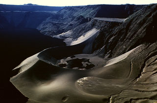
Activity within the caldera. Caldera eruptions likely began sometime between noon on 16 September and the morning of 17 September, but this remains to be confirmed. At 1230 on 17 September two lava flows, each <2 km long, had reached the ephemeral caldera lake. The lava flows in the caldera covered an area of ~4 km2. The steam cloud generated where the lava flows entered the lake looked like a narrow thunderhead reaching 2,600 m as measured by airplane altimeter. Lava from a fissure on a bench along the S caldera wall reached the lake where a pre-existing tuff ring was visible on satellite images. The tuff ring contains another lake, but no lava reached it. Lava from a vent on the caldera floor reached the lake from the opposite direction. No glowing lava was visible in the caldera, but observers flying directly over on 17 September (at ~2,100 m altitude) noticed a strong smell of sulfur.
Threat to tortoises. Human activities have severely reduced populations of two types of Galápagos tortoises. In the past, island residents and whaling crews hunted the tortoises to near extinction. For the last 100 years these populations have been unable to recover due to introduced species (dogs, pigs, and ants) that prey upon nests and hatchlings. One of these two tortoise species has been reduced to fewer than 100 individuals.
The Galápagos National Park Service and CDRS decided to remove tortoises from the affected region, incorporating adults from the more endangered species into their captive breeding and repatriation program. An initial helicopter operation was completed on 1 October, but seven tortoises were apparently killed by lava or associated fires. The 11 tortoises removed were only about half the number needed to establish a serious restoration program. The operation lacks funding for continued access to a helicopter. As a result, another 10 tortoises must be carried out by hand over rugged terrain consisting of aa lava covered by dense thorny vegetation. Adults can weigh up to 225 kg and can travel up to 7 km from shore.
Geological Summary. Located at the SW tip of the J-shaped Isabela Island, Cerro Azul contains a steep-walled 4 x 5 km nested summit caldera complex that is one of the smallest diameter, but at 650 m one of the deepest in the Galápagos Islands. The shield volcano is the second highest of the archipelago. A conspicuous bench occupies the SW and west sides of the caldera, which formed during several episodes of collapse. Youthful lava flows cover much of the caldera floor, which has also contained ephemeral lakes. A prominent tuff cone located at the ENE side of the caldera is evidence of episodic hydrovolcanism. Numerous spatter cones dot the western flanks. Fresh-looking lava flows, many erupted from circumferential fissures, descend the NE and NW flanks. Historical eruptions date back only to 1932, but Cerro Azul has been one of the most active Galápagos volcanoes since that time. Solfataric activity continues within the caldera.
Information Contacts: Howard L. Snell, Charles Darwin Research Station, Puerto Ayora, Galápagos, Ecuador (URL: http://www.darwinfoundation.org/); The Galápagos National Park Service, Isla Santa Cruz, Galápagos, Ecuador; Peter Mouginis-Mark and Luke Flynn, GOES Hotspot Monitoring System, Hawaii Institute of Geophysics and Planetology, University of Hawaii, 2525 Correa Road, Honolulu, Hawaii 96822 (URL: http://modis.higp.hawaii.edu/); Instituto Geofísico, Escuela Politécnica Nacional, AP 17-01-2759, Quito, Ecuador.