Report on Rabaul (Papua New Guinea) — November 1998

Bulletin of the Global Volcanism Network, vol. 23, no. 11 (November 1998)
Managing Editor: Richard Wunderman.
Rabaul (Papua New Guinea) Intermittent emissions continue during October
Please cite this report as:
Global Volcanism Program, 1998. Report on Rabaul (Papua New Guinea) (Wunderman, R., ed.). Bulletin of the Global Volcanism Network, 23:11. Smithsonian Institution. https://doi.org/10.5479/si.GVP.BGVN199811-252140
Rabaul
Papua New Guinea
4.2459°S, 152.1937°E; summit elev. 688 m
All times are local (unless otherwise noted)
Tilt, leveling, and sea-shore surveys continued to record the slow resurgence of the caldera floor observed since April 1996. During October, continued slow magma supply into Rabaul Caldera kept feeding mild Vulcanian activity at Tavurvur cone. Emissions occurred at irregular intervals, from a few minutes to several hours apart. Longer time intervals usually resulted in more powerful and voluminous explosions.
In the beginning of the month, explosions ejected a grayish ash plume 500-1,000 m above the crater. Following a particularly large explosion at 2138 on October 5 (which littered the cone with incandescent ballistic blocks, and displayed dramatic lightning within the dark rising cloud) emissions were larger for a few days, rising to 1,000-3,000 m, although without sounds. During 10-15 October emissions were again milder, hardly rising over 600 m above the crater. Emissions occurring 16-20 October rose to ~1,000 m and were often accompanied by roaring sounds. After 29 October, emissions were again noiseless, and from the 26th onward they became lower in ash content and energy.
October was the transitional period of wind shift. From the 19th, the NW wind began to dominate and bring welcome relief after seven months of very unpleasant, corrosive, and toxic ashfall to Rabaul and neighboring residents.
The recorded seismicity consisted almost exclusively of low-frequency events accompanying the Vulcanian activity from Tavurvur. However, two types of signals were observed: usual short-duration events, and low-amplitude, long-duration (1-3 minutes) events. Their combined number, with an increase in August and September, averaged 46 per day but increased to 81 and 143 on the last two days of October without any corresponding change in visible eruptive activity. The two types of signals usually occurred in subequal amounts, although on 5-7 October the number of long-lasting events started to dominate, while the shorter events prevailed for a few days after the 8th. The amplitude of both types fluctuated substantially for several multi-day intervals during October. Short-duration harmonic signals were also recorded during 16-18 and 24 October. On 20 October the system registered the month's only significant high-frequency event.
A visit to Rabaul by professional photographer George Casey resulted in several images of Tavurvur during August. Casey appreciated the aid kindly given him by RVO staff and was gracious enough to provide us with photos, including one of a small plume on 4 August (figure 32).
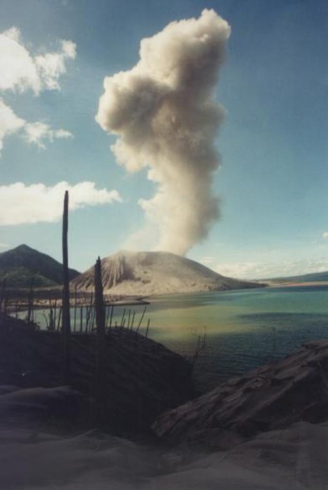 |
Figure 32. The Tavurvur cone at Rabaul emits a small plume on 4 August in this photograph looking SE from the bay's shore. Courtesy of George Casey. |
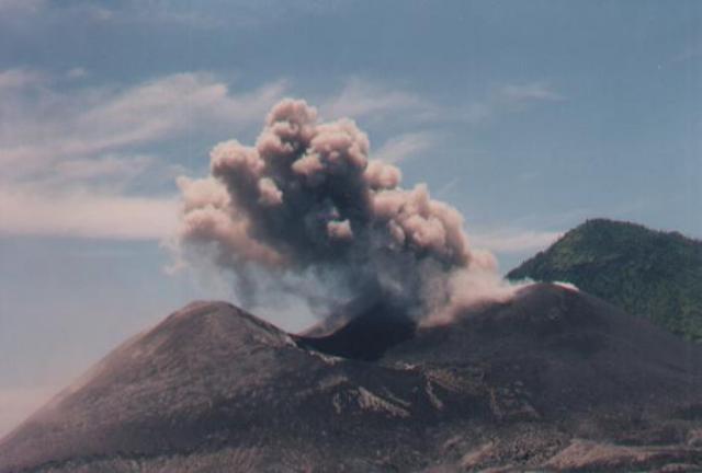 |
Figure 33. An E-facing close-up photograph of the Tavurvur cone at Rabaul from the bay's shore; it emphasizes its low conical shape, wide-aperture crater, and ongoing emissions. Courtesy of George Casey. |
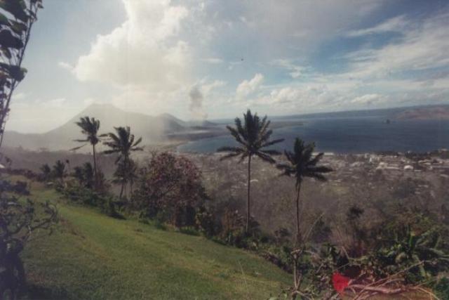 |
Figure 34. SE-looking overview photograph taken on 11 August from Rabaul caldera's topographic margin looking out over the city of Rabaul, Simpson harbor, and the cones that bound the harbor's NE side. The now-resurging caldera is breached by the sea on its E side. Tavurvur cone, ~10 km distant, lies in the peninsular lowlands to the right of the highest peak, Mother (Kombiu), and the lower peak, South Daughter. Courtesy of George Casey. |
Geological Summary. The low-lying Rabaul caldera on the tip of the Gazelle Peninsula at the NE end of New Britain forms a broad sheltered harbor utilized by what was the island's largest city prior to a major eruption in 1994. The outer flanks of the asymmetrical shield volcano are formed by thick pyroclastic-flow deposits. The 8 x 14 km caldera is widely breached on the east, where its floor is flooded by Blanche Bay and was formed about 1,400 years ago. An earlier caldera-forming eruption about 7,100 years ago is thought to have originated from Tavui caldera, offshore to the north. Three small stratovolcanoes lie outside the N and NE caldera rims. Post-caldera eruptions built basaltic-to-dacitic pyroclastic cones on the caldera floor near the NE and W caldera walls. Several of these, including Vulcan cone, which was formed during a large eruption in 1878, have produced major explosive activity during historical time. A powerful explosive eruption in 1994 occurred simultaneously from Vulcan and Tavurvur volcanoes and forced the temporary abandonment of Rabaul city.
Information Contacts: Ben Talai and Patrice de Saint-Ours, Rabaul Volcano Observatory (RVO), P.O. Box 386, Rabaul, Papua New Guinea.