Report on McDonald Islands (Australia) — January 1999
Bulletin of the Global Volcanism Network, vol. 24, no. 1 (January 1999)
Managing Editor: Richard Wunderman.
McDonald Islands (Australia) Fumarolic activity in January seen from passing ship
Please cite this report as:
Global Volcanism Program, 1999. Report on McDonald Islands (Australia) (Wunderman, R., ed.). Bulletin of the Global Volcanism Network, 24:1. Smithsonian Institution. https://doi.org/10.5479/si.GVP.BGVN199901-234011
McDonald Islands
Australia
53.03°S, 72.6°E; summit elev. 230 m
All times are local (unless otherwise noted)
The following was provided by scientists aboard the international Ocean Drilling Program (ODP) Scientific Drilling Vessel JOIDES Resolution based on observations made during the Leg 183 Kerguelen Plateau/Broken Ridge cruise.
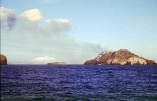
On 13 January 1999, the ship passed within 10 km of Heard Island and 7.1 km of McDonald Island providing excellent views of the lower elevations of Heard Island except for partially obscured views of the Laurens Peninsula. No volcanic activity was evident on Heard Island. McDonald Island had continuing fumarolic activity, particularly between The Needles and Macaroni Hill, N of Samarang Hill. In this area volatiles were emitting from multiple point sources and the rock had a pale color. A "rubbly" flow or debris-fall deposit was observed in the valley extending N from the fumarole field to a few tens of meters above the shoreline. However, no lava fountains or red glows were seen. Similar fumarolic activity was reported in 1997 (BGVN 22:01) although volcanic activity at McDonald Island appears to be more widespread now.
Two partially confined steaming-ground areas were observed on the N and NE flanks of the island. The easternmost of these features extends from a notch below Samarang Hill to sea level. A central finger of steaming ground appears to originate near the main fumarole field in a steep NW-oriented valley. At least two point sources, located high on the SW-facing cliffs S of Samarang Hill, are venting now; no activity has been reported previously on the southern part of the island. No activity was observed in the South Head area.
Geological Summary. Historical eruptions have greatly modified the morphology of the McDonald Islands, located on the Kerguelen Plateau about 75 km W of Heard Island. The largest island, McDonald, is composed of a layered phonolitic tuff plateau cut by phonolitic dikes and lava domes. A possible nearby active submarine center was inferred from phonolitic pumice that washed up on Heard Island in 1992. Volcanic plumes were observed in December 1996 and January 1997 from McDonald Island. During March 1997 the crew of a vessel that sailed near the island noted vigorous steaming from a vent on the N side of the island along with possible pyroclastic deposits and lava flows. A satellite image taken in November 2001 showed the island to have more than doubled in area since previous reported observations in November 2000. The high point of the island group had shifted to the McDonald's N end, which had merged with Flat Island.
Information Contacts: C. Leah Moore, Cooperative Research Center for Landscape Evolution & Mineral Exploration (CRC LEME), University of Canberra, ACT 2601 Australia (URL: http://crcleme.org.au/); Paul Wallace, Ocean Drilling Program (ODP), 1000 Discovery Drive, Texas A&M University, College Station, TX 77845-9547 USA (URL: http://www-odp.tamu.edu/).