Report on Whakaari/White Island (New Zealand) — April 1999

Bulletin of the Global Volcanism Network, vol. 24, no. 4 (April 1999)
Managing Editor: Richard Wunderman.
Whakaari/White Island (New Zealand) Metra Crater excavated by 17 April explosions
Please cite this report as:
Global Volcanism Program, 1999. Report on Whakaari/White Island (New Zealand) (Wunderman, R., ed.). Bulletin of the Global Volcanism Network, 24:4. Smithsonian Institution. https://doi.org/10.5479/si.GVP.BGVN199904-241040
Whakaari/White Island
New Zealand
37.52°S, 177.18°E; summit elev. 294 m
All times are local (unless otherwise noted)
Explosive eruptions on 17 April produced significant changes at Metra Crater. Institute of Geological & Nuclear Sciences (IGNS) scientists visited the volcano on 20 and 30 April to service the seismic installation and assess the effects of the explosive eruptions. These were the largest explosive eruptions since September 1992.
The whole island was blanketed with a thin layer of light-gray ash on 20 April. No single direction of dispersal was apparent, although ground thickness suggested that dispersal was toward the E. The lake in Metra Crater had disappeared and a steam plume traveled to the SE. During the 30 April visit a steam-and-gas plume, fed by emissions from PeeJay Vent and a new vent E of PeeJay, rose 750-900 m before traveling SW (figure 40).
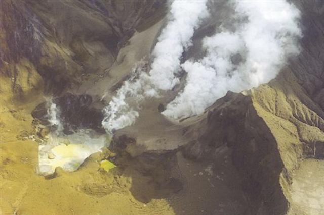 |
Figure 40. Aerial view of 1978/90 Crater Complex on 30 April. Metra Crater is in the left foreground, while the two areas of steam emission in the center are PeeJay Vent and the new vent. Courtesy of IGNS. |
Ballistic blocks and bombs had been ejected 450 m by the 17 April explosions; judging from changes in crater size and shape, they likely came from Metra Crater. The larger fragments fell mainly to the S and SW. Abundant centimeter-size fragments had impacted into new ash around the vents at distances of up to 600 m radius. At least 10 cm of fresh ash had fallen within a 200-m radius of the main crater by 20 April, but rain had caused some erosion and consolidation. The floor of 1978/90 Crater Complex was covered with ash and ballistic ejecta, and much of the original Metra Crater area had been excavated by the recent explosions. Metra was gently steaming and contained a few small puddles of yellow-green brine. Mud bubbling could be heard. No ash fell during the 20 April visit but PeeJay vent discharged white steam and gas. Collapse of the 1978/90 Crater Complex floor, especially between PeeJay and Donald Mound, left concentric cracks around the slumped margins of Metra Crater. A large fumarole had formed E of PeeJay vent. Output of the main fumaroles on the W and E walls did not appear to have changed. Noisy Nellie was producing almost colorless high-temperature steam and gas. Gas emissions around Donald Mound were weak.
Two features were formed by the 17 April explosive excavation of Metra Crater; the W embayment was the deeper and more active feature on 30 April. A small yellow-green lakelet had formed on its floor. The crater's western margins were still collapsing, and several large geothermal features were present, including geyser-like activity in some pools. The strongest fumaroles were on the NW side, emerging from the base of the crater wall, which was 8-10 m high. The E embayment was shallower and did not contain any active geothermal features. One small yellow-green lakelet was present at the W end of this feature. Several open concentric fractures extended around its margins, suggesting that further collapse may occur in this area.
Ballistic blocks reached a maximum of 2 x 2 m. Most of the larger ones were fresh, black, highly vesicular andesite, sometimes with internal plagioclase banding. No evidence of plastic deformation was seen and most blocks had an outer rim of red "baked" ash. The largest blocks had shattered on impact (figure 41). Dense (older, altered) lava was minor with blocks < 0.5 m in size. Lithified crater-fill sediment blocks were common and comprised either dark gray soft sandstone or harder red, yellow, or pale gray hydrothermally altered material. Ejection of the ballistics occurred largely after the main ashfalls, as evidenced by the thin layer of ash coating the blocks. Clear impact craters from small lapilli occurred at distances from the vents.
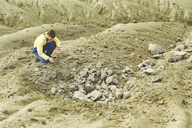 |
Figure 41. Remains of a large volcanic bomb near Metra crater. Courtesy of IGNS. |
Approximately 12 cm of ash was present at Peg Z, but only 2 cm at Peg M on 20 April. A ground-deformation survey of the pegs that survived the April explosions was made on 30 April (figure 42). Seven pegs could not be found. The survey showed subsidence continuing around the ESE margin of 1978/90 Crater Complex, but at a lesser rate than in 1998. Over the remainder of the Main Crater floor weak inflation was apparent at many marks. Although deflationary trends have been observed at some marks since eruptions commenced in 1998, many remained elevated at this time (eg. Pegs C and J).
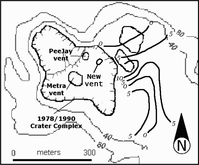 |
Figure 42. Contour map of the active center of White Island volcano. Heavy black lines plot height change in mm between 12 January and 30 April 1999. Courtesy of IGNS. |
A white steam-and-gas plume rose 500-700 m above the 1978/90 Crater Complex during a visit by observers on 10 May. The plume was fed by emissions from PeeJay Vent and the new vent E of PeeJay. Emissions from the new vent were the stronger. The steam-and-gas plume formed acid rain, making conditions unpleasant under the plume and near the edge of the Crater Complex. Enlargement of the yellow-green lakelet within Metra Crater caused flooding into the crater's N embayment. There was no evidence of further explosive activity at Metra Crater.
Geological Summary. The uninhabited Whakaari/White Island is the 2 x 2.4 km emergent summit of a 16 x 18 km submarine volcano in the Bay of Plenty about 50 km offshore of North Island. The island consists of two overlapping andesitic-to-dacitic stratovolcanoes. The SE side of the crater is open at sea level, with the recent activity centered about 1 km from the shore close to the rear crater wall. Volckner Rocks, sea stacks that are remnants of a lava dome, lie 5 km NW. Descriptions of volcanism since 1826 have included intermittent moderate phreatic, phreatomagmatic, and Strombolian eruptions; activity there also forms a prominent part of Maori legends. The formation of many new vents during the 19th and 20th centuries caused rapid changes in crater floor topography. Collapse of the crater wall in 1914 produced a debris avalanche that buried buildings and workers at a sulfur-mining project. Explosive activity in December 2019 took place while tourists were present, resulting in many fatalities. The official government name Whakaari/White Island is a combination of the full Maori name of Te Puia o Whakaari ("The Dramatic Volcano") and White Island (referencing the constant steam plume) given by Captain James Cook in 1769.
Information Contacts: Brad Scott, Wairakei Research Centre, Institute of Geological and Nuclear Sciences (IGNS) Limited, Private Bag 2000, Wairakei, New Zealand (URL: https://www.gns.cri.nz/).