Report on Telica (Nicaragua) — April 1999
Bulletin of the Global Volcanism Network, vol. 24, no. 6 (April 1999)
Managing Editor: Richard Wunderman.
Telica (Nicaragua) Phreatic eruptions in May and June cause local ashfall
Please cite this report as:
Global Volcanism Program, 1999. Report on Telica (Nicaragua) (Wunderman, R., ed.). Bulletin of the Global Volcanism Network, 24:6. Smithsonian Institution. https://doi.org/10.5479/si.GVP.BGVN199904-344040
Telica
Nicaragua
12.606°N, 86.84°W; summit elev. 1036 m
All times are local (unless otherwise noted)
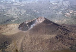
At about 0200 on 21 May a phreatic eruption marked by explosions began from the crater. At daybreak the gas plume extended to ~500 m in height. The following day observers on the crater rim noted a new 50-m-diameter vent on the crater floor. At the time of the observations, an intense gas stream was emanating from the new vent, accompanied by a jet engine-like sound. Fumarolic activity within Telica's crater was much stronger as well. Diminishing phreatic eruptions continued until 23 May. No ashfall was reported. INETER geologists who visited Telica on 18 May had not seen any evidence of increased activity; seismic monitoring did not show any precursors.
Wilfried Strauch reported that new phreatic eruptions took place on 5 June 1999, most notably between 1830 and 1900. These explosions were strong enough to register on nearby seismometers and resulted in minor ashfall in Chichigalpa, ~15 km WSW of Telica. Following the explosions, seismic activity rapidly declined. A 7 June article by La Prensa de Nicaragua stated that 6,000 people had to be evacuated in case of eruption. The article claimed that Telica discharged a cloud of ash to the SW that had bathed the bordering communities and part of Chichigalpa and scattered gas and ash caused adjacent inhabitants near the volcano to suffer irritation of eyes, throat, and nose. Observers noted a steaming area in the W sector of the volcano, 500 m from the crater border.
Crater observations March 1997-February 1998. During March 1997 (BGVN 22:03), INETER recorded high seismicity, ~150 events/day. During December 1996 there had been ~100 events/day. Visits to the summit crater revealed fresh ashfall, numerous small landslides inside the crater, and moderate fumarolic activity in the walls and floor of the crater. Fumaroles lying along a fracture trending NE-SW and located near the seismic station outside the active crater had maximum temperatures of 85°C. Infrared camera measurements on 20 March 1997 detected a zone of high temperatures near the base of the W crater wall.
Seismicity and the extent of fumaroles increased slightly in June 1997 (BGVN 22:06). Whereas in April and May the number of volcano-seismic events was near 160/day (BGVN 22:05), during June this rose to ~220/day. Still, crater degassing remained very small. INETER volcanologists observed that NW-flank fissures had grown in number, extent, and apparent depth. During a previously unreported crater visit by Alain Creusot on 29 September 1997, he observed both a small increase in the fumarolic activity and that an active collapse zone on the N crater rim had enlarged by ~15 m. A portable seismic station recorded both an absence of tremor and 10-15 microearthquakes every hour. A February 1998 visit to Telica's crater (BGVN 23:03) also revealed raised temperatures and an active collapse zone.
Geological Summary. Telica, one of Nicaragua's most active volcanoes, has erupted frequently since the beginning of the Spanish era. This volcano group consists of several interlocking cones and vents with a general NW alignment. Sixteenth-century eruptions were reported at symmetrical Santa Clara volcano at the SW end of the group. However, its eroded and breached crater has been covered by forests throughout historical time, and these eruptions may have originated from Telica, whose upper slopes in contrast are unvegetated. The steep-sided cone of Telica is truncated by a 700-m-wide double crater; the southern crater, the source of recent eruptions, is 120 m deep. El Liston, immediately E, has several nested craters. The fumaroles and boiling mudpots of Hervideros de San Jacinto, SE of Telica, form a prominent geothermal area frequented by tourists, and geothermal exploration has occurred nearby.
Information Contacts: Wilfried Strauch, Virginia Tenorio, and Julio Alvarez, Department of Geophysics, Instituto Nicaraguense de Estudios Territoriales (INETER), P.O. Box 1761, Managua, Nicaragua; La Prensa de Nicaragua, Managua, Nicaragua (URL: http://www.laprensa.com.ni); Alain Creusot, Instituto Nicaraguense de Energía, Managua, Nicaragua.

