Report on Moyorodake [Medvezhia] (Japan - administered by Russia) — October 1999
Bulletin of the Global Volcanism Network, vol. 24, no. 10 (October 1999)
Managing Editor: Richard Wunderman.
Moyorodake [Medvezhia] (Japan - administered by Russia) Small phreatic eruption from the Kudriavy summit forms a new crater
Please cite this report as:
Global Volcanism Program, 1999. Report on Moyorodake [Medvezhia] (Japan - administered by Russia) (Wunderman, R., ed.). Bulletin of the Global Volcanism Network, 24:10. Smithsonian Institution. https://doi.org/10.5479/si.GVP.BGVN199910-290100
Moyorodake [Medvezhia]
Japan - administered by Russia
45.389°N, 148.838°E; summit elev. 1124 m
All times are local (unless otherwise noted)
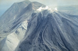
Changes in activity at the Kudriavy cone (figure 2) were detected in mid-September 1999, preceding an eruption on 7 October. Since 1989 the temperatures of sediments in the dry lakes within the crater (lakes temporarily exist after snow melting and strong rains) at a depth of 0.75 m have consistently fallen in the range of 48-82°C, with fluctuations of 3-5°C. In contrast, September 1999 measurements at the control points in the Hot Lake area showed increasing temperatures of 60-102°C. [These temperature measurements have been made 1-3 times each year.]
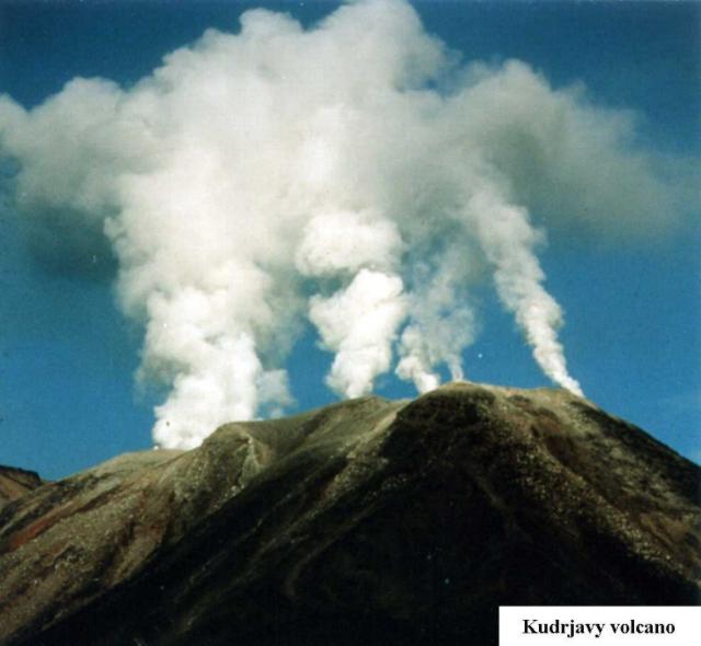 |
Figure 2. Photograph of fumarolic plumes rising from the crater of the Kudriavy cone at Medvezhia, September-October 1999. Courtesy of G.S. Steinberg. |
The weather in August, September, and October was unusually dry for the region, with rain only during 24-25 September and 2-3 October. A temperature survey of two lakes was made in September. Usually, lakes exist 1-2 days after rains, but the water in Hot Lake still covered more than half the area on 4 October. Temperatures in the dry part of the lake had increased by 14-22°C. The lake water close to the hot dome was boiling and seething due to gas emissions. [The hot dome is 150-170 m in diameter, rising 60-70 m above the bottom of Hot Lake to the W and 30-40 m above the bottom of the dry lake to the S.] On 5 October the diameter of the lake was 15 m. That day two channels were excavated to allow the water to drain so that sediment temperatures could be measured. The temperature increase in this newly drained area was more than 30°C. Fumarole gas compositions during the second part of September showed increased hydrogen, oxygen, and fluorine. Sulfur ignition was seen in some locations. The number of earthquakes also increased, and although the one-channel seismic station deployed was insufficient to determine any hypocenters, the elevated seismicity was obvious. District and province authorities were warned three days before the start of the 7 October eruption that Kudriavy was unstable and could erupt soon. [On the evening of 4 October the Governor of Sakhalin and the Mayor of Kurilsk were notified that activity at Kudriavy had rapidly increased and that an eruption was expected to begin during the week of 8-15 October, with possible stronger activity later in the month.]
From the base camp, 3.5 km W from the volcano, black and gray clouds of gas and ash were observed rising above the usual fumarolic plumes at 1735 on 7 October and then extending ~10 km NW. Ejections of gas and ash occurred at intervals of 1-2 minutes. Because of the strong winds, maximum altitude of ejections was 1,100 m. The upper camp was at 940 m elevation, 30-40 m from the crater edge and 300 m from Hot Lake (figure 3). Because of strong winds, bad visibility, and the low-intensity start of the eruption, volcanic tremor and gas-and-ash ejections were not noticed in the upper camp until 10 minutes after observers in the base camp saw the plume. Night observations showed that intense ejections stopped at 0200 on 8 October. Observations through the clouds of the N part of the crater revealed "slight reddish lights - reflected light of the hot rocks and blue lights - light of the burning sulfur" that marked the edges of a crater.
No juvenile ash was identified, so the eruption was determined to be phreatic. This eruption was similar to a geyser eruption: periodic vertical ejection of the gas, ash, and steam. Ejecta didn't fall more than 30-40 m from the new crater. The surface of Hot Lake was covered by rocks with diameters of 20-30 cm, and ashfall deposits were concentrated to the NW. The volume of erupted material was nearly 40,000-45,000 m3. Areas with rhenium mineralization (see BGVN 20:10) located on the dome were not involved in the eruption or covered by eruption products. The first phase of the eruption was over on 13 October.
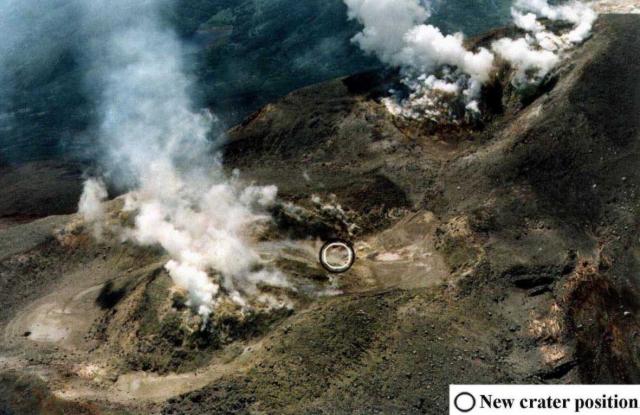
The eruption created a new crater in the Hot Lake area and removed part of the dome (figure 4). The crater was elliptical with dimensions of 30 x 40 m and a depth 35-40 m from the bottom of the lake and 80-110 m from the flat part of the dome (figure 5). The walls of the crater were vertical. In the lower part of the S crater wall was a 6 x 8 m cave of incandescent rocks. Based on the light intensity, the temperature was estimated to be higher than 1,000-1,100°C. Hot gas rose from this area and condensed 40-60 m above the edge of the crater. Small fiery areas and fragments with burning sulfur were seen on the S, W, and N walls. [Minor explosions continued from the cave until 13 October. Activity then declined, consisting of gas emissions with some small rock fragments that didn't reach the crater rim. No significant changes were noted through 2 November, when observations ended.]
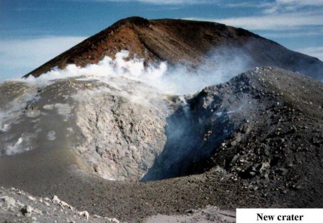 |
Figure 4. Photograph of the hot dome and dry lake area in the N part of the Kudriavy crater at Medvezhia prior to the 7-8 October 1999 eruption. Courtesy of G.S. Steinberg. |
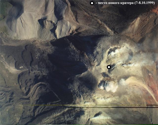 |
Figure 5. Photograph of the 7-8 October 1999 crater adjacent to the hot dome in the N part of the Kudriavy crater at Medvezhia, October 1999. Courtesy of G.S. Steinberg. |
Geological Summary. The Moyorodake volcanic complex (also known as Medvezhia) occupies the NE end of Iturup (Etorofu) Island. Two overlapping calderas, 14 x 18 and 10 x 12 km in diameter, were formed during the Pleistocene. The caldera floor contains several lava domes, cinder cones and associated lava fields, and a small lake. Four small closely spaced stratovolcanoes were constructed along an E-W line on the eastern side of the complex. The easternmost and highest, Medvezhii, lies outside the western caldera, along the Pacific coast. Srednii, Tukap, and Kudriavy (Moyorodake) volcanoes lie immediately to the west. Historically active Moyorodake is younger than 2000 years; it and Tukap remain fumarolically active. The westernmost of the post-caldera cones, Menshoi Brat, is a large lava dome with flank scoria cones, one of which has produced a series of young lava flows up to 4.5 km long that reached Slavnoe Lake. Eruptions have been documented since the 18th century, although lava flows from cinder cones on the flanks of Menshoi Brat were also probably erupted within the past few centuries.
Information Contacts: Genrikh S. Steinberg, Institute of Volcanology and Geodynamics, Russian Academy of Natural Science, Box 18, Yuzhno-Sakhalinsk 693008, Russia.

