Report on Kolbeinsey Ridge (Iceland) — October 1999

Bulletin of the Global Volcanism Network, vol. 24, no. 10 (October 1999)
Managing Editor: Richard Wunderman.
Kolbeinsey Ridge (Iceland) Submarine eruption or dike intrusion south of the Spar Fracture Zone
Please cite this report as:
Global Volcanism Program, 1999. Report on Kolbeinsey Ridge (Iceland) (Wunderman, R., ed.). Bulletin of the Global Volcanism Network, 24:10. Smithsonian Institution. https://doi.org/10.5479/si.GVP.BGVN199910-375010
Kolbeinsey Ridge
Iceland
66.67°N, 18.5°W; summit elev. 5 m
All times are local (unless otherwise noted)
A submarine eruption or dike intrusion on 30 August 1999 was identified by seismic events from the Icelandic Seismological Network (SIL) at the Vedurstofa Islands. The swarm was centered ~180 km N of Grimsey and 100 km N of Kolbeinsey Island near 68.15°N, 17.75°W along the Southern Kolbeinsey Ridge south of the Spar Fracture Zone (figures 1 and 2). Although the swarm started at 0456 (UTC), most of the 143 earthquakes registered occurred between 0830 and 1100, with events continuing until after 2300 (figure 3). Seismic activity on the southern segment of Kolbeinsey Ridge had been registered since 1 July 1999.
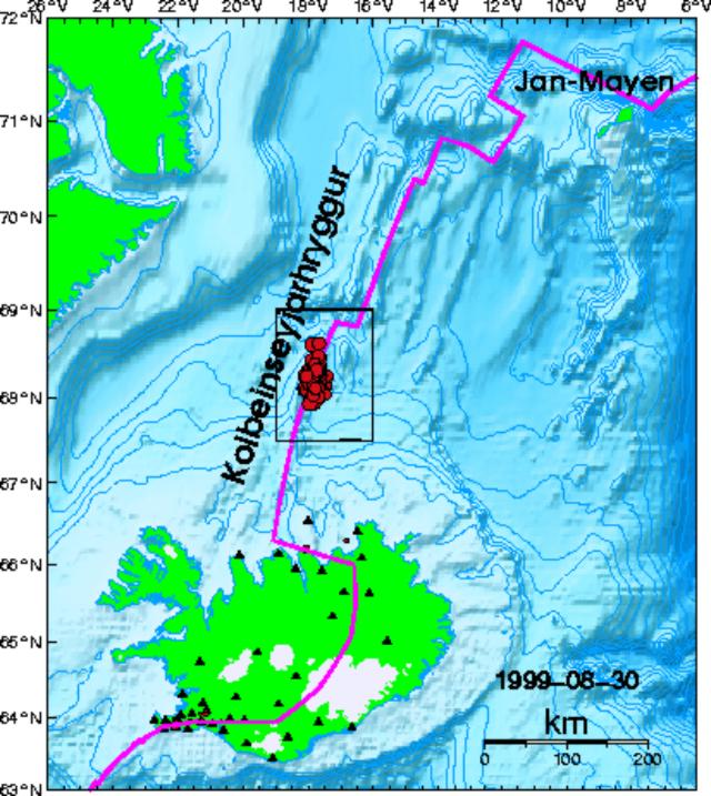 |
Figure 1. Bathymetric relief map showing Iceland, the Kolbeinsey Ridge, and the earthquake swarm of 30 August 1999. Courtesy of the Icelandic Meteorological Office. |
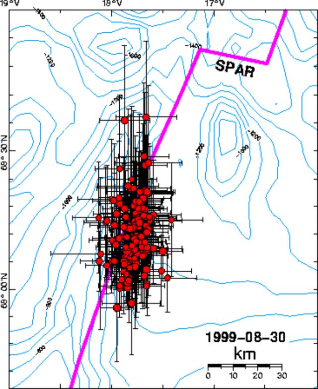 |
Figure 2. Bathymetric map showing the 30 August 1999 earthquake swarm along the Southern Kolbeinsey Ridge south of the Spar Fracture Zone. Courtesy of the Icelandic Meteorological Office. |
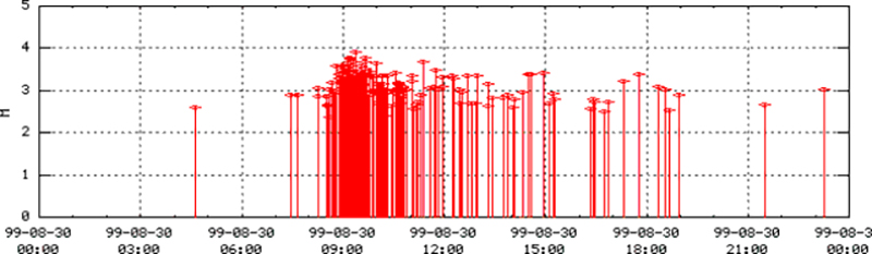 |
Figure 3. Earthquakes from the Kolbeinsey Ridge swarm on 30 August 1999 plotted by time and magnitude. Courtesy of the Icelandic Meteorological Office. |
Kolbeinsey Ridge is divided from Iceland by an oblique running transform fault, the Tjörnes Fracture Zone (TFZ). It is a slow-spreading ridge with an estimated asymmetric spreading of 10 mm/year. The ridge crest is nearly bare of sediments, although the bathymetry is very shallow. Kolbeinsey Ridge is cut by two major transform faults, the Spar Fracture Zone and the 70.8° Fracture Zone, and is thus divided into three segments, the Southern Kolbeinsey Ridge (SKR), the Northern Kolbeinsey Ridge (NKR), and the Central Kolbeinsey Ridge (CKR). The most active part of the ridge is the CKR north of the Spar Fracture Zone. Individual submarine volcanoes have not been named so far because the SIL registers events in detail only up to 300 km N of the Tjörnes Peninsula, covering just the southernmost segment of Kolbeinsey Ridge. Seismic events cluster along three lineaments in the region where the Tjörnes Fracture Zone cuts Kolbeinsey Ridge: the Grimsey lineament (east of Grimsey and N of the actual TFZ), the Husavik-Flatey fault (the actual TFZ), and the Dalvik lineament (cutting the Eyrarfjördur in half subparallel to the actual TFZ). This area is known for its hydrothermal fields made of anhydrite chimneys 200-400 m beneath sea level, which are detected along the seismic lineaments.
A submarine eruption was reported in 1372 on the Kolbeinsey Ridge NW of Grimsey Island at about 66.67°N, but the location is uncertain. Other reports of submarine eruptions N of Iceland have an even more uncertain location (1755) or have been discredited (1783 and 1838).
Further References. Kodaira, S., Mjelde, R., Gunnarsson, K., Shiobara, I., and Shimamura, H., 1997, Crustal structure of the Kolbeinsey Ridge, North Atlantic, obtained by use of ocean bottom, seismographs: JGR, v. 102, B2.
Rögnvaldsson, S.T., Gudmundsson, A., and Slunga, R., 1998, Seismotectonic analysis of the Tjörnes Fracture Zone, an active transform fault in north Iceland: JGR, v. 103, B12.
Geological Summary. A submarine eruption was reported in 1372 CE near the Kolbeinsey Ridge NW of Grimsey Island. Kolbeinsey Island, the only subaerial expression of this portion of the Mid-Atlantic Ridge, is a small, rapidly eroding island that formed during the late Pleistocene or Holocene. Dredged glass shards indicate submarine eruptive activity during the late-Pleistocene until at least 11,800 radiocarbon years ago. The island was 700 m long in 1616 CE, but had shrunk to 42 m long and 5 m high by 1985. The Kolbeinsey Hydrothermal Field lies south of the island. Thorarinsson (1965) roughly plotted the location of the 1372 eruption at about 66°40'N. Reidel et al. (2003) note that the location is uncertain, but could lie between the Kolbeinsey Ridge and Hóll Seamount. Other reports of submarine eruptions north of Iceland have an even more uncertain location (1755) or have been discredited (1783 and 1838).
Information Contacts: Carsten Riedel, Christian-Albrechts-Universität, Kiel, Germany (URL: http://www.ifg.uni-kiel.de/); Icelandic Meteorological Office, Bustadavegur 9, 150 Reykjavík, Iceland (URL: http://www.vedur.is/).