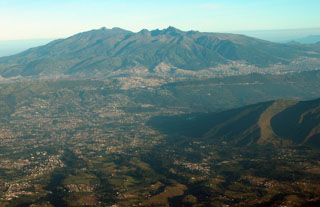
Report on Guagua Pichincha (Ecuador) — June 2000
Bulletin of the Global Volcanism Network, vol. 25, no. 6 (June 2000)
Managing Editor: Richard Wunderman.
Guagua Pichincha (Ecuador) Minor ash eruptions; partial collapse of January 2000 dome on 12 July
Please cite this report as:
Global Volcanism Program, 2000. Report on Guagua Pichincha (Ecuador) (Wunderman, R., ed.). Bulletin of the Global Volcanism Network, 25:6. Smithsonian Institution. https://doi.org/10.5479/si.GVP.BGVN200006-352020
Guagua Pichincha
Ecuador
0.171°S, 78.598°W; summit elev. 4784 m
All times are local (unless otherwise noted)
This report discusses activity at Guagua Pichincha during the months of June and July 2000. A Washington Volcanic Ash Advisory Center (VAAC) advisory was issued at 1337 on 2 June after a minor ash explosion propelled a plume to 7.3 km altitude above the summit. Another small eruption occurred one week later at 0941 on 9 June. Emissions from this second eruption did not rise more than 5 km, but more earthquakes and rockfalls indicated increasing instability of the January 2000 lava dome.
At 0953 on 12 July the dome experienced a partial collapse on its W side. This is the area of the dome closest to the W opening of the horseshoe-shaped caldera. High on the slope of the volcano's W flank, just below the caldera's opening, is the origin of the Cristál river. A long-period (LP) earthquake with a reduced displacement of 14.5 cm2 probably destabilized the dome and caused the partial collapse. Judging by seismic data, the ash plume may have risen ~12 km above the crater, but cloud cover inhibited visual observations. A strong wind blew most ash W, away from the city of Quito, and very fine ash blanketed the caldera. Seismicity remained low after the eruption, but a slight increase in the number of rockfalls indicated that the dome was still unstable.
Two other events occurred during July. An ash plume was also sighted at 0900 on 23 July at an estimated height of 6.1 km moving W. An aviation notice at 0900 on 24 July described ash from six emissions over the course of the previous night that reached 4.8 km altitude, a height comparable to the volcano's summit elevation.
Over 14,530 LP events were registered in the month of March and this number decreased to 6,892 in April; there was a reported average of 271 LP events daily for the year 2000. The number of monthly explosions dropped to almost zero during the period of January to April; this was the first time there have been so few explosions since the month of July 1998. Volcano-tectonic seismicity also dropped dramatically during January-July 2000, averaging approximately the same number of monthly events as seen prior to activity that began in October 1999. The number of rockfall events has remained high since dome growth began in January 2000; thus far in the year 2000 there has been an average of 72 daily rockfalls. Beginning around June 2000 these events have occurred 100-200 times per day. Two main seismic centers have been inferred at Guagua Pichincha from data; one center is less than 1 km below the crater surface and the second ~2-4 km deeper. Continued fumarolic activity has been moderate but variable.
Geological Summary. Guagua Pichincha and the older Pleistocene Rucu Pichincha stratovolcanoes form a broad volcanic massif that rises immediately W of Ecuador's capital city, Quito. A lava dome grew at the head of a 6-km-wide scarp formed during a late-Pleistocene slope failure ~50,000 years ago. Subsequent late-Pleistocene and Holocene eruptions from the central vent consisted of explosive activity with pyroclastic flows accompanied by periodic growth and destruction of the lava dome. Many minor eruptions have been recorded since the mid-1500's; the largest took place in 1660, when ash fell over a 1,000 km radius and accumulated to 30 cm depth in Quito. Pyroclastic flows and surges also occurred, primarily to then W, and affected agricultural activity.
Information Contacts: Instituto Geofísico, Escuela Politécnica Nacional, Apartado 17-01-2759, Quito, Ecuador (URL: http://www.igepn.edu.ec/); Washington Volcanic Ash Advisory Center (VAAC), Satellite Analysis Branch, NOAA/NESDIS E/SP23, NOAA Science Center Room 401, 5200 Auth Road, Camp Springs, MD 20746, USA (URL: http://www.ssd.noaa.gov/); Associated Press.

