Report on Miyakejima (Japan) — July 2000
Bulletin of the Global Volcanism Network, vol. 25, no. 7 (July 2000)
Managing Editor: Richard Wunderman.
Miyakejima (Japan) Robust, multifaceted eruptions from new summit crater
Please cite this report as:
Global Volcanism Program, 2000. Report on Miyakejima (Japan) (Wunderman, R., ed.). Bulletin of the Global Volcanism Network, 25:7. Smithsonian Institution. https://doi.org/10.5479/si.GVP.BGVN200007-284040
Miyakejima
Japan
34.094°N, 139.526°E; summit elev. 775 m
All times are local (unless otherwise noted)
This report covers the period 8 July-31 August 2000, an interval marked by strong outbursts, spectacular plumes, pyroclastic flows, ashfalls, and a remarkable series of concentric crater collapses that followed the initial crater collapse on 8 July 2000 (figures 6 and 7). Striking ash-column photos, some marked with azimuthal angles and calculated plume heights, appear on Japanese-language websites (see below).
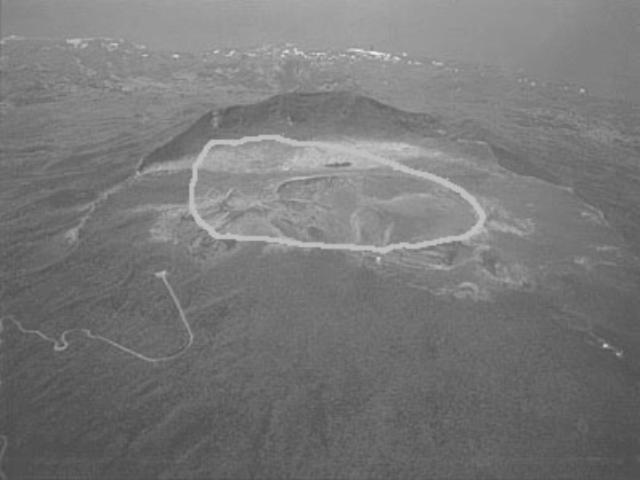 |
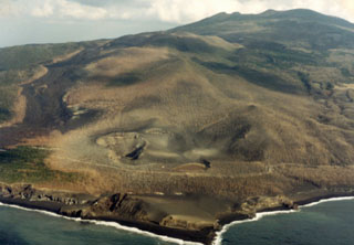
Figure 6. An oblique aerial view of Miyake-jima's pre-eruption summit; the sketched-in curve indicates the area of the collapse on 8 July 2000. That area is sub-circular in plan view (figure 7) and has a diameter of ~ 0.9 km. View is looking NNE. Courtesy of Tokyo Metropolitan Islands Promotion Corporation. |
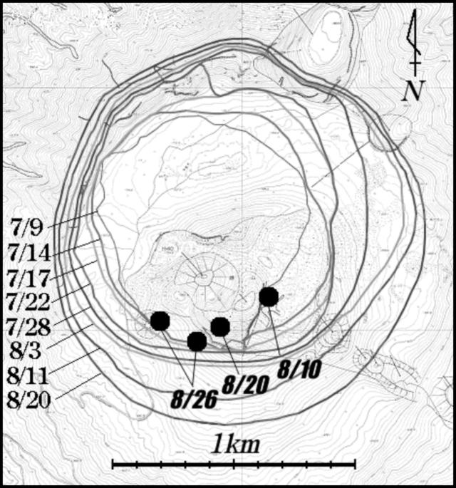 |
Figure 7. Map of Miyake-jima's active summit crater documenting the crater's expansion during July and August 2000. The margins were drawn from aerial photos taken on the specified dates. The progression was thought to be closely linked with summit deflation; this deflation had been detected since the end of June and accelerated on 8 July. Large dots indicate the locations of a series of small migrating vents seen in the crater during 10-26 August. From the website of K. F. Fujita. |
Continuous deflation at the summit had been recorded since the end of June. However, on 8 July the deflation accelerated. Following 4 days of earthquake swarms under the summit, at 1841 on 8 July, a small, phreatic explosion sent a cloud to 800 m above the summit (BGVN 25:07). This explosion lasted several minutes. At the same time, a large pit crater formed with a diameter of ~800-1,000 m and a depth of 100-200 m. A small amount of ash was ejected but was not comparable to the volume of the depression. Red ash and cinder deposits from this eruption were estimated to amount to less than 1 x 10⁶ m3. The volume of collapse was estimated at 50 x 106 m3. No scoriae or any other juvenile material was found. The rapid deflation is thought to have formed as the result of "drain-back" of magma that had intruded near the surface. This appears to have been the catalyst for the explosion.
After the 8 July explosion, tiltmeters recorded periods of sudden inflation. Inflations were preceded and accompanied by long-period earthquakes located less than 2 km below the surface. The intervals of inflation and earthquakes were followed by continued steady deflation. This cycle repeated itself approximately every 12 hours from the 8 July eruption to 23 July.
Following a series of foreshocks, at 1601 on 1 July a Mb 6.1 earthquake struck near Kozu-shima Island, NW of Miyake-jima. This was followed on 14 July by a M 5.3 earthquake off the coast of Miyake-jima. At about 0400, shortly after the earthquake, a phreatic eruption occurred. Thick layers of ash were deposited on the N and E parts of the islands. This eruption continued until about 1300 on 15 July. Photographs taken by Asahi News Network (ANN) on the afternoon of 14 July showed that the 8 July crater had expanded to a diameter of 1,000 m and a depth of 400 m. Observers looking at the bottom of the 8 July crater saw small phreatic explosions yielding plumes with convoluted and scrolled shapes (reminiscent of cock's tails); these originated from a new pit crater that was ~100 m in diameter. The volume of ash from this eruption was estimated to be less than 10 x 106 m3. The volume of collapse was estimated at 200 x 106 m3.
Measurements in early August showed that the collapsed crater had enlarged to a diameter of 1.4 km and a depth of 450 m. According to The Japan Times, an eruption on 10 August produced a plume that rose 3 km above the summit and deposited ash over the NE section of the island. Yukio Hayakawa reported that small pyroclastic flows accompanied this event. After 10 August, phreatic explosions occurred intermittently. Figure 7 shows the progressive expansion of the crater associated with the deflation. GPS measurements made at four stations around the summit indicated continued summit deflation, including during the explosion on 18 August.
At 1700 on 18 August, a large phreatic eruption occurred. This was the largest eruption since activity began on 26 June 2000. Yukio Hayakawa reported small pyroclastic flows. According to articles by the Associated Press and Reuters, white clouds rising to 8 km above the summit were encountered by a commercial airline pilot who was in route from Guam to Narita airport in Tokyo. The plane, which was flying over the island of Miyake shortly after the eruption, later landed safely at Narita. Aviation contacts later revealed that while in flight a commercial airliner encountered airborne ash and underwent a dual-engine flame-out, but managed to land safely. The airliner sustained ~$4 million (US dollars) in damage.
Ash fall was reported to be heaviest on the western part of the island, but ash in the NW sector accumulated up to 15 cm thick as far as 3 km from the crater (figure 8). Ballistics, which included basaltic bombs, were ejected at the end of the eruption and were deposited in a uniform, radial pattern around the crater (figure 9). On the W slope of the volcano, 2-m-diameter ballistics destroyed roofs of cowsheds and formed craters in the meadows. To the SE, there were reports of broken car windows and cinders 5 cm in diameter at the airport. It is uncertain whether these ballistics were juvenile material.
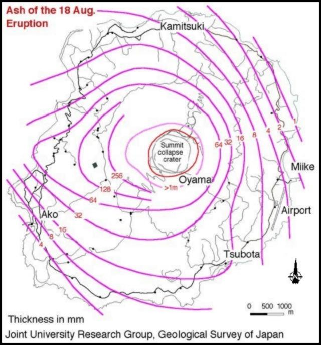 |
Figure 8. Isopach map of ash-fall deposits from Miyake-jima's eruption on 18 August 2000. Courtesy of Joint University Research Group, Geological Survey of Japan. |
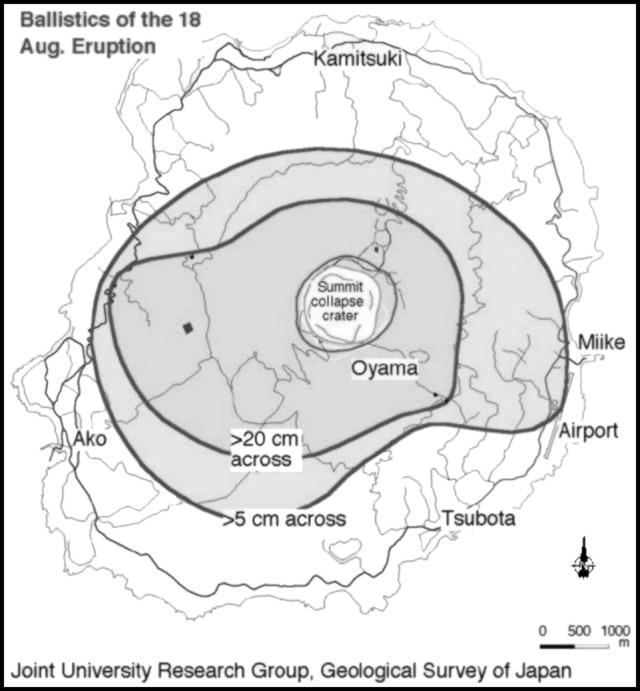 |
Figure 9. Isopleth map of ballistics from Miyake-jima's eruption on 18 August 2000. Courtesy of Joint University Research Group, Geological Survey of Japan. |
Although several lower plume-height observations and estimates were made, for example by aviators, one based on a photograph of the actively rising ash column indicated that the 18 August plume rose to at least 15 km. Laser radar (lidar) provided additional constraints on the height of airborne volcanic aerosols at distance from the volcano, detecting them on 23 August at 16 and 17.5 km altitude. More details follow.
For the 18 August eruption, lidar data collected by Takashi Shibata established these values at Nagoya, Japan (35°N, 137°E, on S Honshu Island, 290 km SE of the volcano) around 2100 on 23 August: backscatter ratio at 532 nm, 1.1; depolarization ratio at 532 nm, 5%; plume height, 16 km; and plume width, 100 km.
On 23 August the lidar instrument run by Motowo Fujiwara and Kouichi Shiraishi in Fukuoka (33.5°N, 130.4°E, on NW Kyushu Island, 850 km W of the volcano) detected a thin aerosol layer. Their measurement took place over an interval that began at 0013 and extended over the next hour and a half. They detected relatively strong scattering in the lower stratosphere and found these values: peak backscatter ratio at 532 nm, 1.20-1.25; depolarization ratio at 532 nm, 8-15%; layer height, 17.5 km; and layer width, 1 km. The cited height corresponds to the peak (strongest effect) of the layer; this altitude was ~1.7 km above the tropopause observed by Fukuoka Meteorological Observatory at 2100 on 22 August. Fujiwara and Shiraishi suggested aerosols might have come from Miyake-jima, specifically its eruption at 1702 on 18 August. The Meteorological Observatory reported that during the period from 18-21 August the wind direction around the layer height (17-18 km) changed from ENE to SSE (i.e., basically easterly) and its speed changed from 3 to 7 m/s. These easterly winds further suggested that the lidar-detected aerosol layer originated from a Miyake-jima eruption.
Observations made on 20 August by Osamu Oshima of the University of Tokyo revealed 3 small cones with open pits inside the summit crater, multiple mudflows from the crater pits onto the crater floor, and step faults that crossed new ash layers. He interpreted the step faults to indicate continued subsistence of the crater floor.
The Tokyo VAAC reported three small eruptions at Miyake-jima on 28 August. The eruption clouds reached respective heights of about 5.8, 3.8, and 5 km. On 29 August at 0430, Miyake-jima erupted vigorously again; according to the Eruption Committee this was the second-largest outburst of the recent eruptive episode (the most vigorous being the 18 August eruption). There were two pyroclastic flows, one to the NE that extended 5 km to the sea, and one to the SW that extended for 3 km. The pyroclastic flows contained large amounts of HCl, unlike those of 18 August. The eruption was theorized to be the result of either the collapse of an unstable hydrothermal system or contact between magma and meteoric water inside the volcano. Photos of the pyroclastic flows appeared on the internet (see references).
According to an article by the Associated Press and the Japanese news agency Asahi Shimbun, on 29 August all students, teachers, and school officials on Miyake-jima were evacuated to Tokyo, and all remaining residents of the island were ordered to evacuate. Residents who had not yet left the island as of 31 August were being housed in shelters due to the threat of mudslides produced by thick ash and rain.
Geological Summary. The circular, 8-km-wide island of Miyakejima forms a low-angle stratovolcano that rises about 1,100 m from the sea floor in the northern Izu Islands about 200 km SSW of Tokyo. The basaltic volcano is truncated by small summit calderas, one of which, 3.5 km wide, was formed during a major eruption about 2,500 years ago. Numerous craters and vents, including maars near the coast and radially oriented fissure vents, are present on the flanks. Frequent eruptions have been recorded since 1085 CE at vents ranging from the summit to below sea level, causing much damage on this small populated island. After a three-century-long hiatus ending in 1469 CE, activity has been dominated by flank fissure eruptions sometimes accompanied by minor summit eruptions. A 1.6-km-wide summit crater was slowly formed by subsidence during an eruption in 2000.
Information Contacts: Miyake-jima Meterological Observatory and Volcanological Division; Japan Meteorological Agency (JMA), 1-3-4 Ote-machi, Chiyoda-ku, Tokyo 100, Japan (URL: http://www.jma.go.jp/); Akihiko Tomiya, Geological Survey of Japan, 1-1-3 Higashi, Ibaraki, Tsukuba 305, Japan (URL: https://www.gsj.jp/); Setsuya Nakada, Volcano Research Center, Earthquake Research Institute, University of Tokyo, Yayoi 1-1-1, Bunkyo-ku, Tokyo 113-0032, Japan (URL: http://www.eri.u-tokyo.ac.jp/VRC/index_E.html); Takashi Shibata, STEL, Nagoya University, Furo-cho, Chikusa-ku, Nagoya 464-8601, Japan; Yukio Hayakawa, Faculty of Education, Gunma University, Aramaki, Maebashi 371, Japan (URL: http://www.hayakawayukio.jp/); Motowo Fujiwara and Kouichi Shiraishi, Department of Earth System Science, Fukuoka University, 8-19-1 Nanakuma, Jonann-ku, Fukuoka 814-0180, Japan; U.S. Geological Survey, Reston, VA, USA (URL: http://www.usgs.gov); The Japan Times, 5-4, Shibaura 4-chome, Minato-ku, Tokyo 108-0023 (URL: http://www.japantimes.co.jp/); Asahi Shimbun (URL: http://www.asahi.com/english/english.html); Associated Press; Reuters.