Report on Masaya (Nicaragua) — July 2000

Bulletin of the Global Volcanism Network, vol. 25, no. 7 (July 2000)
Managing Editor: Richard Wunderman.
Masaya (Nicaragua) Summary of activity; nearby M 5.4 earthquake at 1 km focal depth on 6 July
Please cite this report as:
Global Volcanism Program, 2000. Report on Masaya (Nicaragua) (Wunderman, R., ed.). Bulletin of the Global Volcanism Network, 25:7. Smithsonian Institution. https://doi.org/10.5479/si.GVP.BGVN200007-344100
Masaya
Nicaragua
11.9844°N, 86.1688°W; summit elev. 594 m
All times are local (unless otherwise noted)
Since the last report on Masaya, of continued degassing and marked gravity decreases (BGVN 24:04), there have been sporadic reports about its activity, which are summarized below prior to discussion of a nearby M 5.4 earthquake on 6 July 2000.
Reports of ash-and-steam emissions. Between November 1999 and January 2000 there were several reports from the Washington VAAC of ash-and-steam emissions from Masaya. On 22 November 1999 the VAAC reported that GOES-8 imagery suggested that Masaya may have awakened. Satellite imagery showed activity at or very near Masaya, including a plume of ash or "smoke" moving to the WSW, and a hotspot that was visible for over two hours. At about 1600 the imagery suggested that an explosion may have occurred and by 1615 the resultant plume was at ~800 m (near Masaya's summit), and had been blown WSW.
On 22 December 1999 the Washington VAAC issued an ash advisory stating that a continuous low-level plume was being emitted from Masaya. Volcanic activity was confirmed by INETER who noted that seismic activity was consistent with ash emissions. The cloud was ~2 km in altitude and was blown to the WSW.
On 18 January 2000 the VAAC reported that GOES-8 imagery through 0845 detected a low-level thin ash plume from Masaya's summit. The plume reached an altitude of ~900 m, was blown to the SW, and rapidly dissipated.
Seismic activity during April 1999-March 2000. Seismic activity at the volcano remained low with eight microearthquakes registered for the month. The RSAM (seismic tremor) stayed at ~30 units. During the first two weeks of April the RSAM signal was not obtained due to technical problems in the seismic power station. On 23 April two explosions were detected by RSAM, which were confirmed by observers at the Masaya Volcano National Park. In that case, RSAM began to show a small increase until 0800, and an hour later the two explosions occurred.
May 1999: The number of microearthquakes was 21 for the month. The RSAM stayed at ~24 units. June: The number of microearthquakes was 18 for the month. The RSAM stayed at ~24 units. August: The number of microearthquakes was 47 for the month. The RSAM remained at ~40 units. Constant gas emissions occurred. September: The number of microearthquakes was 87 for the month. The RSAM stayed constant at ~40 units. Constant gas emissions occurred. October: The number of microearthquakes was 22 for the month. The RSAM stayed constant at ~20 units. Constant gas emissions occurred. November: There were 49 microearthquakes for the month. The RSAM stayed constant. Constant gas emissions occurred. December: Twenty one earthquakes were registered for the month. The RSAM stayed constant.
January 2000: Eleven earthquakes were registered for the month. The RSAM stayed constant. At 1145 on 6 January an explosion occurred in Santiago crater. February: Six microearthquakes and the RSAM remained constant. March: There were three microearthquakes for the month. The RSAM was at a similar level as the previous month.
July 2000 seismicity near Masaya and Laguna de Apoyo. During July 2000 there were over 300 earthquakes near Laguna de Apoyo (Apoyo volcano) and Masaya. The earthquakes, determined to be of tectonic rather than volcanic origin, caused surficial damage at both volcanoes.
At 1329 on 6 July a small M 2 earthquake occurred near the N rim of Laguna de Apoyo that was followed at 1330 by a M 5.4 earthquake (figure 10). It was located ~32 km SE of Managua, at 11.96°N, 86.02°E, with a focal depth less than 1 km (figure 11). The earthquake was felt in most of Nicaragua and was most strongly felt in the cities of Managua (Modified Mercalli V-VI) and Masaya (VI), and in the region near Laguna de Apoyo (maximum intensity of VII or VIII). The earthquake caused numerous landslides down the volcano's crater walls and surface faulting was observed. In towns located in the epicentral zone, trees and electric lines fell and many houses were partially or totally destroyed. About 70 people were injured and four children were killed by collapsing walls or roofs of homes. At Masaya volcano, ~8 km from the epicenter, there were minor collapses of Santiago crater's walls. No change in degassing was observed at the volcano.
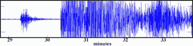 |
Figure 10. Seismogram showing the M 2 and M 5.4 earthquakes near the Masaya volcano station on 6 July 2000. Courtesy of INETER. |
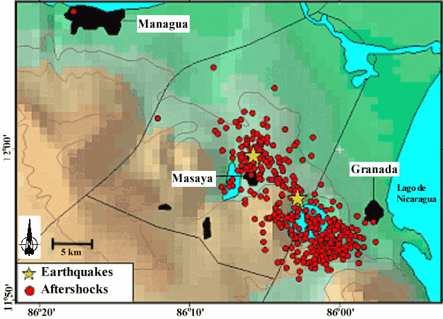 |
Figure 11. Epicenters near Masaya for the M 5.4 earthquake on 6 July, and the M 4.8 earthquake on 25 July 2000 (stars). The aftershocks from these earthquakes are also shown (small circles). Courtesy of INETER. |
Immediately after the earthquake there were many smaller, shallow earthquakes in a zone that includes the area between Masaya, Laguna de Apoyo, and W of Granada (figure 11). In the epicentral zone property was destroyed, cracks opened in the ground, landslides occurred, and trees fell. Several landslides occurred at the edges and steep walls of Laguna de Apoyo. A large number of earthquakes continued until 10 July (figure 12 and table 2). The number of earthquakes then diminished until 1554 on 25 July when a M 4.8 earthquake took place, initiating a series of smaller earthquakes that lasted until about 27 July.
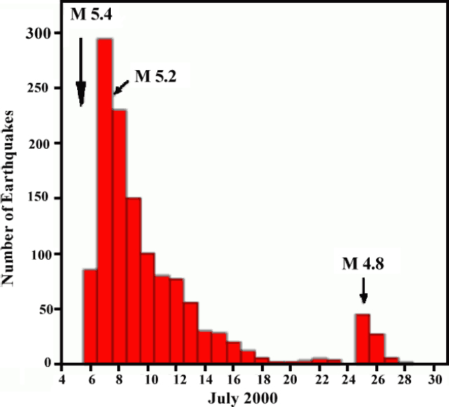 |
Figure 12. Graph showing the number of earthquakes in the Masaya region between 4 and 30 July 2000. Courtesy of INETER. |
Table 2. A summary of earthquakes in vicinity of Masaya and Laguna de Apoyo in early July 2000. Courtesy of INETER.
| Date | Time | Number of daily earthquakes | Maximum magnitude |
| 07 Jul 2000 | 1330 | 180 | 5.2 |
| 08 Jul 2000 | 1100 | 70 | 3.8 |
| 09 Jul 2000 | 1200 | 81 | 3.6 |
| 10 Jul 2000 | 1800 | 27 | 3.1 |
| 11 Jul 2000 | 1800 | 6 | 3.3 |
| 13 Jul 2000 | 1800 | 16 | 2.8 |
The July earthquakes were the most destructive seismic events since the 1972 Managua earthquake. The epicentral zone of the July 2000 earthquakes correlates with the same active zones of past earthquakes, which are caused by fault movement between the Cocos and Caribbean plates.
Geological Summary. Masaya volcano in Nicaragua has erupted frequently since the time of the Spanish Conquistadors, when an active lava lake prompted attempts to extract the volcano's molten "gold" until it was found to be basalt rock upon cooling. It lies within the massive Pleistocene Las Sierras caldera and is itself a broad, 6 x 11 km basaltic caldera with steep-sided walls up to 300 m high. The caldera is filled on its NW end by more than a dozen vents that erupted along a circular, 4-km-diameter fracture system. The Nindirí and Masaya cones, the source of observed eruptions, were constructed at the southern end of the fracture system and contain multiple summit craters, including the currently active Santiago crater. A major basaltic Plinian tephra erupted from Masaya about 6,500 years ago. Recent lava flows cover much of the caldera floor and there is a lake at the far eastern end. A lava flow from the 1670 eruption overtopped the north caldera rim. Periods of long-term vigorous gas emission at roughly quarter-century intervals have caused health hazards and crop damage.
Information Contacts: Wilfried Strauch and Virginia Tenorio, Dirección General de Geofísica, Instituto Nicaragüense de Estudios Territoriales (INETER), Apartado 1761, Managua, Nicaragua (URL: http://www.ineter.gob.ni/); Washington VAAC, Satellite Analysis Branch (SAB), NOAA/NESDIS E/SP23, NOAA Science Center Room 401, 5200 Auth Road, Camp Springs, MD 20746, USA (URL: http://www.ssd.noaa.gov/).