Report on Arenal (Costa Rica) — August 2000

Bulletin of the Global Volcanism Network, vol. 25, no. 8 (August 2000)
Managing Editor: Richard Wunderman.
Arenal (Costa Rica) Maps, photos, and seismic data on the 23 August eruption
Please cite this report as:
Global Volcanism Program, 2000. Report on Arenal (Costa Rica) (Wunderman, R., ed.). Bulletin of the Global Volcanism Network, 25:8. Smithsonian Institution. https://doi.org/10.5479/si.GVP.BGVN200008-345033
Arenal
Costa Rica
10.463°N, 84.703°W; summit elev. 1670 m
All times are local (unless otherwise noted)
More details have emerged about the 23 August pyroclastic flows (BGVN 25:07) that cut a bold swath for several kilometers across the volcano's well-vegetated N flanks (figures 90 and 91).
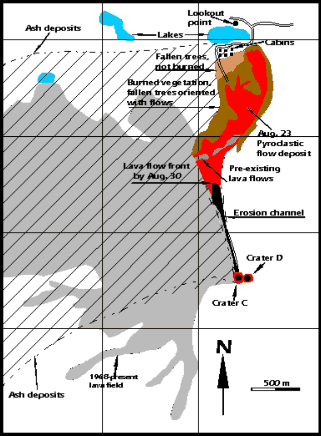 |
Figure 90. Sketch map of the area around Arenal showing the 23 August 2000 pyroclastic-flow deposit, including its various mapped zones, and showing the area of deposition for the associated ash fall over the NW quadrant. Beyond the distal end of the pyroclastic flows lies Cedeño lake. The other small lake ~1 km to the W is unnamed. The Tabacón river valley lies to Arenal's NW and crosses the region about a kilometer W of the unnamed lake. Courtesy of OVSICORI-UNA. |
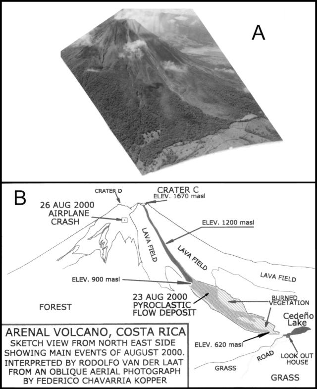 |
Figure 91. Oblique aerial photo taken around 0630 on 13 September 2000 by Federico Chavarria Kopper (A) showing the area of Arenal's NE flank ravaged by the 23 August pyroclastic flows. The large lake in the center-right background is Lake Arenal, a dammed reservoir that generates hydroelectric power. Interpretive diagram (B) identifying critical features on part A (prepared by Rodolfo Van der Laat, OVSICORI-UNA). |
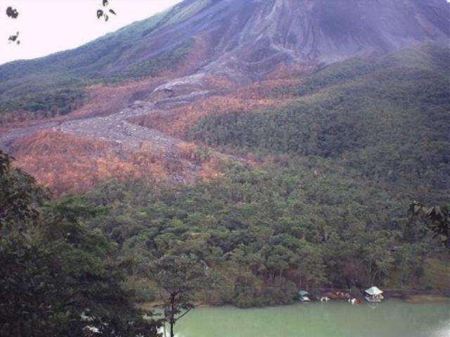 |
Figure 92. Photograph of Arenal taken on 18 September 2000 looking S, showing the swath of the 23 August pyroclastic flows. Cedeño lake lies in the foreground. Photo taken by William G. Melson from the overlook just N of Cedeño lake. |
After visiting Arenal with colleagues at OVSCICORI-UNA, William G. Melson noted that the pyroclastic flows had the character of a block-bomb-and-ash flow. He noted that prior to the event, a spatter cone grew at the N rim of Crater C. Although material regularly sloughed off this cone in smaller, hot mass-wasting events and occasional pyroclastic flows, on 23 August there was a substantial ash column and fallback pyroclastic flows.
The descending pyroclastic flows (figures 90 and 91) followed a N-directed erosional channel. Thereafter, they swerved gently E and broadened, leaving a complex pattern of affected zones. At the distal end, a lodge and its cluster of camping shelters stood just outside the burned zone. Pyroclastic flows had not descended quite so far in this direction in the recent past.
Contrary to some press reports, the eruption on 23 August was not inordinately large and was considerably smaller than the 1968 outbursts. Those much more violent outbursts took on the order of 80 lives, destroyed two towns, and discharged numerous ballistic blocks, including some that landed up to 5 km from the vent.
Although it remains potentially fatal to venture onto Arenal's slopes, tourists continue to repeatedly do so. For example, on 6 July 1988 a man from Pennsylvania was struck by a bomb and killed while standing next to the summit crater. In February 1999, Steve O'Meara found lodge personnel handing out crude maps to tourists. Navigating on the basis of these maps, some tourists found themselves dodging dislodged boulders. One injured tourist had to be escorted off the volcano. Authorities confront the complex and difficult balance that weighs public safety against tourism, resort development, and public access.
OVSICORI-UNA reports and related data. OVSICORI-UNA reported that on 23 August various seismic events occurred associated with the emplacement of the N-flank pyroclastic flows. The pyroclastic flows traveled 2.35 km (straight-line distance) and descended to 620 m elevation. The initial pyroclastic flows had small volumes and went only short distances. Melson's digital seismic instrument detected several prominent peaks in RSAM data on the morning of 23 August (figure 93). According to various reports, the initial pyroclastic flows began around 0930-1000. OVSICORI-UNA stated that the most mobile pyroclastic flows began at 1336 and recurred during an interval of 74 minutes. These were thought to coincide with intervals of vigorous eruptions. This larger flow entered thick forest and halted just tens of meters from the tourist areas called Los Lagos and Senderos, a spot at ~620 m elevation (figure 90). Fallen trees remained unburned at the pyroclastic flow's terminal end, forming a roughly triangular zone over its W side, in the area adjacent to the cabins.
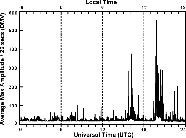 |
Figure 93. Arenal seismic summary showing RSAM calculated from the E-W component. The data were collected on a continuously operating, 3-component seismograph at the indicated times on 23 August 2000. Data registered at the Arenal Observatory Lodge, 2.7 km S of the summit (Macademia station). The bottom scale indicates Universal Time (GMT) and the upper scale, local time. Courtesy of William G. Melson and Jorge Barquero. |
Although in the main body of flow the vegetation had come to rest aligned in the direction of the pyroclastic flow's travel, at the terminal end some trees lay without preferential orientations. Along the front and margin of the area impacted by the pyroclastic flows, some still-standing trees suffered damage, including loss of bark due to ash abrasion. Local winds carried ash columns to the W. At sampling points El Cruce and Lavas (4.6 km WNW and 1.5 km W of Crater C, respectively) the loads of deposited ash amounted to 296 and 1,073 g/m2.
The deposit left by the pyroclastic flows consisted of a sand-sized tephra comprising 20-50% of the deposit, containing semi-rounded blocks with cooling joints and a scoriaceous character, including some bread-crust bombs. The largest of these semi-rounded clasts reached 3 x 1 x 1.8 m. Angular blocks reached 9.5 x 4.4 x 2.8 m. In places, the passing pyroclastic flows both caused erosion and incorporated significant quantities of pre-existing rocks.
During 23 and 24 August there were 42 seismic signals. These were interpreted as associated with the emplacement of pyroclastic flows. Some of these pyroclastic flows originated from collapse at the upper reaches of the actively moving, N-directed lava flows in the area very close to crater C. Others may have involved fallback of the eruptive columns, and collapse of over-steepened summit slopes.
In the months of September and October, Arenal continued to produce active lava flows. Soon after the 23 August event, a lava flow descended to the N, traveling down the same erosional channel over the new pyroclastic-flow deposit. Its front reached ~1,200 m elevation by mid September and though slowing, it reached ~900 m elevation by 3 October. It was followed by a second lava flow, which descended over the first. By 3 October this second flow had advanced to ~1,200 m elevation. Figure 91(B) indicates the positions of the fronts for the first and second lava flows. Both lava flows remained active into at least mid-October.
RSN-ICE-USR reports. Seismic data were collected by the Miravalles-Arenal Seismological and Volcanological Observatory (OSIVAM) and the National Seismological Network (RSN) over the months leading up to the 23 August event (figure 94). Their instruments detected an increase in the tremor signals several hours before the first outburst, and the seismic noise was stronger during subsequent hours due to the flows that lasted until the late afternoon of 23 August. The RSN and their affiliates at ICE-UCR reported that Arenal's activity increased at about 0955 on 23 August. The resulting pyroclastic flows were accompanied by strong ash and gas columns more than 1 km high. Ash fall during the course of the eruptions brought darkness to the vicinity of Arenal as far as the town of Tilarán, 20 km to the W. The number of pyroclastic flows on 23 August was estimated to be at least 20.
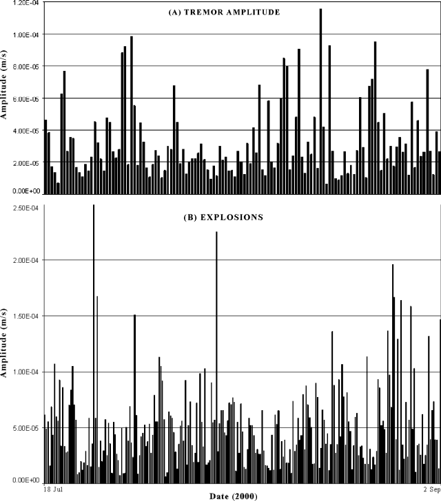 |
Figure 94. Arenal seismic data covering the interval 19 June to 3 September 2000, composed of (A) tremor amplitude and (B) amplitude of explosion events. All data were registered on digital instrument(s) at undisclosed location(s). Courtesy of Ivonne Arroyo and Francisco Arias, OSIVAM. |
On the basis of field surveys on the day of the event, Guillermo Alvarado estimated the velocity of the pyroclastic flows at 80-120 km/hour. The pyroclastic-flow deposits averaged 3 m thick and reached a maximum thickness of 6 m. The flows destroyed OSIVAM-ICE's dry-tilt station E.
Zones prone to small pyroclastic flows, such as those of 23 August, are indicated on a volcanic risk map developed by ICE and Geotérmica Italiana (Alvarado and others, 1988, 1997). That map delineated a hazardous zone extending down this (and other Arenal drainages) and continuing many kilometers beyond lake Cedeño. During an undisclosed time interval, the National Commission of Emergencies (CNE) evacuated several tourist sites near Arenal and closed access to them.
Airplane crash. Additional details have emerged about the airplane that crashed into Arenal on 26 August (impact site indicated on figure 91). The plane carried ten people, presumably two pilots and eight passengers, many of whom were foreign tourists. (BGVN 25:07 stated that the plane carried ten passengers.) One of the passengers was a reporter who had written about the fate of the guide, Ignacio Protti, who died of burns soon after his exposure to the pyroclastic flows. The plane had deviated from its normal route along the coast, probably to gain a view of the area disturbed by the new pyroclastic flows.
References. Alvarado, G.E., Matumoto, T., Borgia, A., and Barquero, R., 1988, Síntesis geovulcanológica del Arenal (Costa Rica): 20 años de continua actividad eruptiva (1968-1988): Rev. Geogr. Amer. Central, v. 25-26, p. 413-459.
Alvarado, G.E., Soto, G.J., Ghigliotti, M., and Frullani, A., 1997, Peligro volcánico del Arenal: Bol. OSIVAM, 8 (15-16):62-82, 1995; San José.
Geological Summary. Conical Volcán Arenal is the youngest stratovolcano in Costa Rica and one of its most active. The 1670-m-high andesitic volcano towers above the eastern shores of Lake Arenal, which has been enlarged by a hydroelectric project. Arenal lies along a volcanic chain that has migrated to the NW from the late-Pleistocene Los Perdidos lava domes through the Pleistocene-to-Holocene Chato volcano, which contains a 500-m-wide, lake-filled summit crater. The earliest known eruptions of Arenal took place about 7000 years ago, and it was active concurrently with Cerro Chato until the activity of Chato ended about 3500 years ago. Growth of Arenal has been characterized by periodic major explosive eruptions at several-hundred-year intervals and periods of lava effusion that armor the cone. An eruptive period that began with a major explosive eruption in 1968 ended in December 2010; continuous explosive activity accompanied by slow lava effusion and the occasional emission of pyroclastic flows characterized the eruption from vents at the summit and on the upper western flank.
Information Contacts: Observatorio Vulcanologico y Sismologico de Costa Rica, Universidad Nacional (OVSICORI-UNA), Apartado 86-3000, Heredia, Costa Rica; Oficina de Sismología y Vulcanología del Arenal y Miravalles: OSIVAM, Instituto Costarricense de Electricidad (ICE), Apartado 10032-1000, San José, Costa Rica; William Melson, Mineral Sciences, NMNH, Smithsonian Institution, Washington, DC 20560-0119, USA.