Report on Merapi (Indonesia) — January 2001

Bulletin of the Global Volcanism Network, vol. 26, no. 1 (January 2001)
Managing Editor: Richard Wunderman.
Merapi (Indonesia) Failure of 1998 lava dome on 10 February causes major eruption
Please cite this report as:
Global Volcanism Program, 2001. Report on Merapi (Indonesia) (Wunderman, R., ed.). Bulletin of the Global Volcanism Network, 26:1. Smithsonian Institution. https://doi.org/10.5479/si.GVP.BGVN200101-263250
Merapi
Indonesia
7.54°S, 110.446°E; summit elev. 2910 m
All times are local (unless otherwise noted)
Renewed unrest began on the night of 27 January with continuous pyroclastic flows and hot lava avalanches, which lasted up to two hours. Since mid-January a Level 3 hazard status has remained in effect for the volcano. The Volcanological Society of Indonesia (VSI) reported that on 28 January 2001 Merapi's "2001" lava dome (BGVN 25:12) partially collapsed resulting in pyroclastic flows and hot lava avalanches with recurrence intervals of ~2-5 minutes. Pyroclastic material flowed down to the Sat, Bebeng, and Senowo Rivers, to the SW, SW, and W of Merapi, respectively. Their maximum runout distance occurred in the Sat River drainage, where flows reached ~4.5 km from the source. A plume, thick with sulfurous ash, rose 2 km above the summit. The eruption generated ashfalls within a radius of 15-20 km; ash fell on the Dukun, Srumbung, Salam, Ngluwar, and Muntilan Districts surrounding Merapi.
VSI geophysicist Ratdomopurbo reported that the unstable lava dome was actively growing taller and larger; continued magma chamber injection had caused the pyroclastic flows and lava avalanches at the surface. Magma migration was indicated by increased deep volcanic (A-type) and shallow volcanic (B-type) earthquakes since August 2000. On 31 January pyroclastic flows occurred continuously, reaching up to ~3.5 km from the summit and flowing mainly into the Sat River, but also into the Senowo and Bebeng Rivers. At Babadan Observatory, located 4 km from the summit, a seismograph recorded earthquakes related to pyroclastic flows that exceeded the instrument's scale for up to 60 seconds during the interval of 1601-1822. Ashfall continued within 15 km of Merapi. A recent photograph showed a new active vent on Merapi's summit. VSI scientists engaged in Merapi research remained uncertain whether the vent in the photo had only emitted gases or had also emitted lava and tephra.
Pyroclastic flows and lava avalanches continued through 5 February (figures 20 and 21). Approximately 25 pyroclastic flows occurred daily and moved down the flanks to the Sat, Bebeng, and Senowo Rivers with a maximum runout distance of 4.5 km. Lava avalanches flowed down to the Lamat River, W of the volcano, in addition to the three above-mentioned rivers; lava avalanches reached a distance of 3.5 km from Merapi's summit, falling 1 km short of flows from the previous week. Ashfalls continued, and heavy rain on 3 February caused a minor lahar that initiated at 0430. Summarizing observations, Syamsul Rizal Wittiri stated that Merapi's lava dome continued to grow larger with the addition of ~45,000 cubic meters of material per day; lava dome volume as of 6 February was 1 million cubic meters. On 9 February at 2100 a continuous pyroclastic flow occurred for ~1 hour.
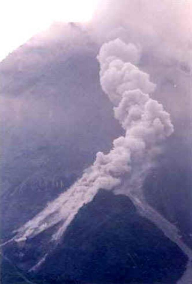 |
Figure 20. A west-flank pyroclastic flow travels down Merapi. Photo taken during the week of 30 January-5 February. Courtesy of VSI. |
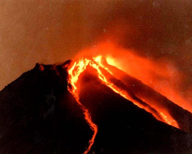 |
Figure 21. Night view of Merapi shows incandescent lava avalanches down several flanks. Photo taken during the week of 30 January-5 February. Courtesy of VSI. |
A major eruptive episode occurred on 10 February (figure 22). At 0200 purported magma migration toward the surface was associated with a medium-sized, 30-minute-long pyroclastic flow. At 0330 failure of the 1998 lava dome sent an ash cloud billowing 5 km above the summit and generated sizable pyroclastic flows that extended up to 7 km from Merapi in the direction of the Sat River and 4.5 km in the direction of the Lamat River. At 0530 Merapi's alert was raised from 3 to 4, the highest level, for the first time since July 1998 (BGVN 23:07). The ash plume from the eruption spread 60 km toward the E over the communities of Klaten, Solo, Sukoharjo, and Boyolali. Ashfall produced an ash layer with a maximum thickness of 1 cm at a 5 km radius from the volcano. Stations recorded high seismicity accompanying the eruption. Instrumentation detected decreasing magnetic intensity near the summit, indicating high heat and magma near the surface.
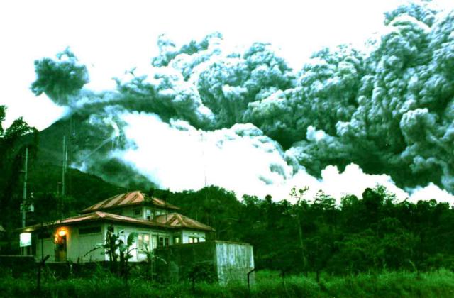 |
Figure 22. A pyroclastic flow on 10 February 2001 sweeping down Merapi's W flanks. Only a small ash cloud rises sub-vertically from the summit. In the left foreground lies the Babadan Observatory Post; it sits on the mid-flanks ~ 7 km W of the summit. Courtesy of VSI. |
Syamsul Rizal Wittiri predicted that Merapi's activity will continue and potentially increase because the 2001 lava dome, which attained a volume of 1.4 million cubic meters, is unstable due to the collapse of the 1998 dome. Merapi's alert level remained at 4 as of 14 February.
Geological Summary. Merapi, one of Indonesia's most active volcanoes, lies in one of the world's most densely populated areas and dominates the landscape immediately north of the major city of Yogyakarta. It is the youngest and southernmost of a volcanic chain extending NNW to Ungaran volcano. Growth of Old Merapi during the Pleistocene ended with major edifice collapse perhaps about 2,000 years ago, leaving a large arcuate scarp cutting the eroded older Batulawang volcano. Subsequent growth of the steep-sided Young Merapi edifice, its upper part unvegetated due to frequent activity, began SW of the earlier collapse scarp. Pyroclastic flows and lahars accompanying growth and collapse of the steep-sided active summit lava dome have devastated cultivated lands on the western-to-southern flanks and caused many fatalities.
Information Contacts: Dali Ahmad, Volcanological Survey of Indonesia (VSI), Jalan Diponegoro No. 57, Bandung 40122, Indonesia (URL: http://www.vsi.esdm.go.id/); Darwin Volcanic Ash Advisory Centre (VAAC), Bureau of Meteorology, Northern Territory Regional Office, PO Box 40050, Casuarina, NT 0811, Australia (URL: http://www.bom.gov.au/info/vaac/).