Report on Tengger Caldera (Indonesia) — January 2001
Bulletin of the Global Volcanism Network, vol. 26, no. 1 (January 2001)
Managing Editor: Richard Wunderman.
Tengger Caldera (Indonesia) Minor explosions, ash emissions, and tremor through 8 January 2001
Please cite this report as:
Global Volcanism Program, 2001. Report on Tengger Caldera (Indonesia) (Wunderman, R., ed.). Bulletin of the Global Volcanism Network, 26:1. Smithsonian Institution. https://doi.org/10.5479/si.GVP.BGVN200101-263310
Tengger Caldera
Indonesia
7.942°S, 112.95°E; summit elev. 2329 m
All times are local (unless otherwise noted)
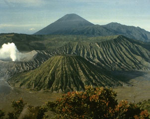
Explosions from Bromo cone and unbroken tremor continued at Tengger Caldera since the previous report (BGVN 25:11). An average of 99 minor explosions daily during 19-25 December 2000 produced gray-brown ash that rose ~300-450 m above the cone's rim. The volcano's seismograph recorded 678 explosion earthquakes and tremor with amplitudes that ranged from 2 to 12 mm.
VSI reports resumed during 2-8 January 2001 when activity was purportedly lower. Small explosions sent gray-brown to dark ash 200 m above the crater, and about 29 events occurred per day. The seismograph registered 191 explosion earthquakes and continuous tremor with amplitudes of 2-10 mm. Tengger's hazard status remained at 2 (on a scale of 1-4), and no further VSI reports were issued. The Darwin Volcanic Ash Advisory Centre, however, issued an advisory to aviators on 15 January to warn them of an ash cloud up to an altitude of 3 km drifting toward the NE. The advisory also stated that ground-based observations indicated that irregular eruptions sent ash up to altitudes of 2,750 m, over 400 m above the Bromo cone. When the report was issued, ash was expected to spread E-NE at ~30 km/hour; heavy cloud-cover prevented the acquisition of satellite information concerning the eruption. No further ash advisories were released after 15 January.
Geological Summary. The 16-km-wide Tengger caldera is located at the northern end of a volcanic massif extending from Semeru volcano. The massive volcanic complex dates back to about 820,000 years ago and consists of five overlapping stratovolcanoes, each truncated by a caldera. Lava domes, pyroclastic cones, and a maar occupy the flanks of the massif. The Ngadisari caldera at the NE end of the complex formed about 150,000 years ago and is now drained through the Sapikerep valley. The most recent of the calderas is the 9 x 10 km wide Sandsea caldera at the SW end of the complex, which formed incrementally during the late Pleistocene and early Holocene. An overlapping cluster of post-caldera cones was constructed on the floor of the Sandsea caldera within the past several thousand years. The youngest of these is Bromo, one of Java's most active and most frequently visited volcanoes.
Information Contacts: Dali Ahmad, Volcanological Survey of Indonesia (VSI), Jalan Diponegoro No. 57, Bandung 40122, Indonesia (URL: http://www.vsi.esdm.go.id/); Darwin Volcanic Ash Advisory Centre (VAAC), Bureau of Meteorology, Northern Territory Regional Office, PO Box 40050, Casuarina, NT 0811, Australia (URL: http://www.bom.gov.au/info/vaac/).