Report on Inielika (Indonesia) — January 2001
Bulletin of the Global Volcanism Network, vol. 26, no. 1 (January 2001)
Managing Editor: Richard Wunderman.
Inielika (Indonesia) Explosive activity declines; new images of the summit area
Please cite this report as:
Global Volcanism Program, 2001. Report on Inielika (Indonesia) (Wunderman, R., ed.). Bulletin of the Global Volcanism Network, 26:1. Smithsonian Institution. https://doi.org/10.5479/si.GVP.BGVN200101-264090
Inielika
Indonesia
8.73°S, 120.98°E; summit elev. 1559 m
All times are local (unless otherwise noted)
The following report covers Inielika's activity during 23 January-5 February 2001. The VSI issued three photographs showing Inielika's summit area (figures 1-3). No explosions occurred during 23-29 January, unlike earlier in the month (BGVN 25:12). Instead, a white gas-and-steam plume rose 100-500 m above the summit. Volcanic earthquakes, tectonic earthquakes, and continuous tremor with amplitudes varying from 0.3 to 1.2 mm occurred.
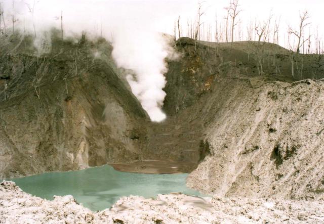 |
Figure 1. A gas-and-steam plume exiting from one of Inielika's craters on 11 January 2001. Courtesy of VSI. |
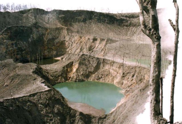 |
Figure 2. View of Inielika's summit crater lakes as seen on 11 January 2001. The lake in the center foreground is green, and the lake behind and to the left of it is a dark color. A light-colored plume issues from a vent on the right side of the image. Which of the volcano's ten craters these represent remains uncertain. Courtesy of VSI. |
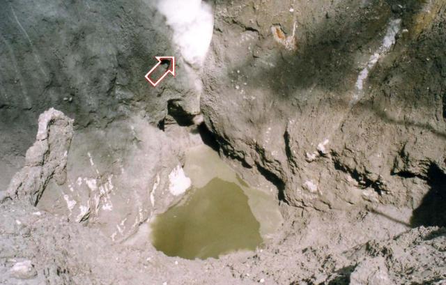 |
Figure 3. A recently formed vent (arrow) seen in a crater on Inielika's summit on 11 January 2001. Courtesy of VSI. |
Activity remained relatively similar during the following week of 30 January-5 February. A gas-and-steam plume rose 25-500 m above the summit. The number of deep volcanic (A-type) earthquakes increased with respect to the previous week, and tremor was no longer continuous. The VSI maintained Inielika's hazard status at Level 3 (on a scale of 1-4) as of 5 February.
Geological Summary. Inielika is a broad, low volcano in central Flores Island that was constructed within the Lobobutu caldera. The complex summit contains ten craters, some of which are lake filled, in a 5 km2 area north of the city of Bajawa. The largest of these, Wolo Runu and Wolo Lega North, are 750 m wide. A phreatic explosion in 1905 formed a new crater, and was the volcano's only eruption during the 20th century. Another eruption took place about a century later, in 2001. A chain of Pleistocene cinder cones, the Bajawa cinder cone complex, extends southward to Inierie.
Information Contacts: Dali Ahmad, Volcanological Survey of Indonesia (VSI), Jalan Diponegoro No. 57, Bandung 40122, Indonesia (URL: http://www.vsi.esdm.go.id/).