Report on Rabaul (Papua New Guinea) — June 2001

Bulletin of the Global Volcanism Network, vol. 26, no. 6 (June 2001)
Managing Editor: Richard Wunderman.
Rabaul (Papua New Guinea) Intermittent ash eruptions continue during January-May
Please cite this report as:
Global Volcanism Program, 2001. Report on Rabaul (Papua New Guinea) (Wunderman, R., ed.). Bulletin of the Global Volcanism Network, 26:6. Smithsonian Institution. https://doi.org/10.5479/si.GVP.BGVN200106-252140
Rabaul
Papua New Guinea
4.2459°S, 152.1937°E; summit elev. 688 m
All times are local (unless otherwise noted)
This report covers the period from November 2000 through May 2001. Activity at Rabaul was relatively low through this period until 14 March, when low-frequency earthquakes resumed and continued to increase in number and amplitude throughout that month. These earthquakes were apparently precursors to an ash eruption at Tavurvur on 2 April after several months of relative quiet.
Occasional ash-laden clouds resulting from mild explosions occurred in January and February. White vapors were released in varying amounts from Tavurvur. Two large explosions occurred on 12 and 26 January producing a dark gray, billowing ash cloud that rose to ~1,000-2,000 m above the summit before dispersing W and NW. The explosions showered the flank of the volcano with rock fragments and deposited significant amounts of ash on Rabaul Town. For short periods during these months H2S was smelled downwind of Tavurvur.
Seventeen high-frequency earthquakes were recorded in March, only five of which were determined as having originated from NE and ESE of the caldera. No high-frequency earthquakes have been recorded on the once-active ring-fault seismic zone since 1995. Between February and the end of March, GPS recorded ~1.5 cm of uplift in the central part of the caldera, while an electronic tiltmeter measured ~3-4 µrad of inflation.
The caldera had previously subsided about 4 cm on 16 November 2000, associated with earthquakes N of Rabaul. According to the UN Office for the Coordination of Humanitarian Affairs (OCHA), two earthquakes, M 7-8, occurred in Papua New Guinea about 3 hours apart on 16 November. The first earthquake was ~50 km N of Rabaul and just S of New Ireland. The second earthquake struck ~100-150 km from Rabaul and N of New Ireland, near the Lihir, Tabar, and Tanga Islands. Both earthquakes occurred about 50 km below sea level. Tsunami of 1-2.5 m height caused damage on New Britain, New Ireland, and Bougainville, leaving thousands homeless; no casualties were reported. At least four other M ~6.5 aftershocks were reported in the following days. According to the BBC, recent tectonic activity has caused subsidence of coral islands between New Ireland and New Britain. As many as 40,000 people may need to be evacuated.
At 1300 on 2 April the number and amplitude of the low-frequency earthquakes increased again, culminating in the first ash clouds between 2100 and 2200. Figure 36 shows an ash eruption on 4 April 2001. Similar low-frequency earthquakes were noted a few days before the 28 November 1995 eruption. High-frequency earthquakes, another good indicator of eruptive activity, continued to occur on the NE side of the volcano during April 2001. Other parameters indicating signs of likely renewed eruptive activity were 3-4 months of slow inflation in the central part of Rabaul Caldera, GPS measurements that showed ~3-4 cm of uplift, and tiltmeter measurements near the GPS benchmark and ~2 km from Tavurvur that also indicted inflation. The smell of sulfuric gas was noted occasionally.
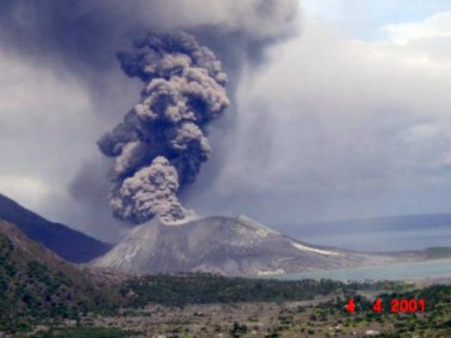 |
Figure 36. Ash eruption on 4 April 2001 at the Tavurvur cone. This photo was taken looking from the NW and shows the SE side of the cone. Courtesy of RVO. |
From 2 to 24 April Tavurvur's ash emissions fluctuated between white to pale-gray ash clouds and sub-continuous ejection of pale- to dark-gray ash clouds. Beginning at about 1400 on 25 April, activity changed to short explosions that produced white to pale-gray mushroom-shaped ash columns and were usually accompanied by roaring noises. During the month ash clouds rose from a few hundred to ~1,000 m above the summit area. Variable winds blew the ash N and NW. Similar eruptive activity continued through the end of April.
During April, 1,089 low-frequency (LF) earthquakes were registered by the trigger system. Daily LF totals ranged between 0 and 291. High LF totals occurred on the 25th (172), 26th (291), 27th (228), and 28th (212). This period corresponded to the time when the mode of Tavurvur's eruptive activity changed from occasional sub-continuous ash cloud emissions to frequent, short-duration ash cloud expulsions. The totals for April 2001 were substantially higher than for the previous months of January (22), February (31), and March (13). During April, short duration, non-harmonic volcanic tremors were also recorded and were usually associated with the sub-continuous ash cloud emissions. On the other hand, during April the system recorded only six high-frequency earthquakes, fewer than in January (15), February (8), and March (17). Moreover, in April, half of the high-frequency earthquakes struck to the NE and outside the caldera.
During May, Tavurvur emitted pale gray to white ash clouds, sometimes accompanied by 0.5-2 minute periods of roaring. The ash clouds typically reached as high as several hundred meters above the vent. During the first half of May incandescent explosions were observed at night, but towards the end of May these explosions lessened in frequency and vigor. The roaring noises also lessened. On 30 May the roaring noises were replaced by stronger, discrete explosions. These produced dark ash clouds that rose to 1-1.5 km above the vent. In general, intra-caldera seismicity was low in frequency and associated with explosions. Almost 2,000 seismic events were recorded.
The unambiguous inflationary trend observed over the previous six months slowed in early May, and a period of relative stability occurred until the end of the month. The start of the darker emissions heralded a period of small-scale rapidly fluctuating vertical movements, but no overall inflationary or deflationary trend predominated.
Geological Summary. The low-lying Rabaul caldera on the tip of the Gazelle Peninsula at the NE end of New Britain forms a broad sheltered harbor utilized by what was the island's largest city prior to a major eruption in 1994. The outer flanks of the asymmetrical shield volcano are formed by thick pyroclastic-flow deposits. The 8 x 14 km caldera is widely breached on the east, where its floor is flooded by Blanche Bay and was formed about 1,400 years ago. An earlier caldera-forming eruption about 7,100 years ago is thought to have originated from Tavui caldera, offshore to the north. Three small stratovolcanoes lie outside the N and NE caldera rims. Post-caldera eruptions built basaltic-to-dacitic pyroclastic cones on the caldera floor near the NE and W caldera walls. Several of these, including Vulcan cone, which was formed during a large eruption in 1878, have produced major explosive activity during historical time. A powerful explosive eruption in 1994 occurred simultaneously from Vulcan and Tavurvur volcanoes and forced the temporary abandonment of Rabaul city.
Information Contacts: Ima Itikarai, Rabaul Volcano Observatory (RVO), P.O. Box 386, Rabaul, Papua New Guinea.