Report on Makushin (United States) — June 2001
Bulletin of the Global Volcanism Network, vol. 26, no. 6 (June 2001)
Managing Editor: Richard Wunderman.
Makushin (United States) Slight increase in small earthquakes during July 2000-June 2001
Please cite this report as:
Global Volcanism Program, 2001. Report on Makushin (United States) (Wunderman, R., ed.). Bulletin of the Global Volcanism Network, 26:6. Smithsonian Institution. https://doi.org/10.5479/si.GVP.BGVN200106-311310
Makushin
United States
53.891°N, 166.923°W; summit elev. 1800 m
All times are local (unless otherwise noted)
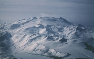
The last eruption of Makushin occurred on 30 January 1995 and produced an ash cloud that rose to ~2.5 km altitude (BGVN 20:01). The Alaska Volcano Observatory reported that during July 2000 to June 2001 they detected a slight increase in the number of small earthquakes beneath Makushin. The volcano is located 25 km W of the city of Unalaska/Dutch Harbor in the eastern Aleutian Islands. Hypocenters of the earthquakes generally ranged between 0 and 8 km depth. The events had magnitudes of 0-1.5, so they were too small to be felt by humans. The earthquakes were not thought to be immediate precursors to eruptive activity because similar fluctuations in seismic activity have been observed at a number of Aleutian volcanoes and were not followed by eruptions. The level of concern color code remained at Green.
Geological Summary. The ice-covered Makushin volcano on northern Unalaska Island is capped by a 2.5 km caldera. Its broad, dome-like structure contrasts with the steep-sided profiles of most other Aleutian stratovolcanoes. Much of the edifice was formed during the Pleistocene, but the caldera (which formed about 8,000 years ago), Sugarloaf cone on the ENE flank, and a cluster of about a dozen explosion pits and cinder cones at Point Kadin on the WNW flank, are of Holocene age. A broad band of NE-SW-trending vents cuts across the volcano. The composite Pakushin cone, with multiple summit craters, lies 8 km SW. Table Top (Pleistocene, 68 +/- 14 ka) and Wide Bay (Holocene) cinder cones are about 20 km ENE on the peninsula across the bay from the City of Unalaska. Frequent explosive eruptions have occurred during the past 4,000 years, sometimes accompanied by pyroclastic flows and surges. Geothermal areas are found in the summit caldera and on the SE and E flanks. Small-to-moderate explosive eruptions have been recorded since 1786.
Information Contacts: Alaska Volcano Observatory (AVO), a cooperative program of a) U.S. Geological Survey, 4200 University Drive, Anchorage, AK 99508-4667, USA (URL: http://www.avo.alaska.edu/), b) Geophysical Institute, University of Alaska, PO Box 757320, Fairbanks, AK 99775-7320, USA, and c) Alaska Division of Geological & Geophysical Surveys, 794 University Ave., Suite 200, Fairbanks, AK 99709, USA.