Report on Okmok (United States) — August 2001
Bulletin of the Global Volcanism Network, vol. 26, no. 8 (August 2001)
Managing Editor: Richard Wunderman.
Okmok (United States) Small earthquake swarm during 11-15 May 2001
Please cite this report as:
Global Volcanism Program, 2001. Report on Okmok (United States) (Wunderman, R., ed.). Bulletin of the Global Volcanism Network, 26:8. Smithsonian Institution. https://doi.org/10.5479/si.GVP.BGVN200108-311290
Okmok
United States
53.43°N, 168.13°W; summit elev. 1073 m
All times are local (unless otherwise noted)
Since the February 1997 eruption (BGVN 22:04) until at least September 2001, Okmok has remained relatively quiet, with one period of increased seismic activity. On 11 May 2001, from about 0800 to at least 1700, the Alaska Volcano Observatory (AVO) detected a small earthquake swarm centered near the volcano. Earthquakes in the swarm had magnitudes ranging from ~2 to 3.6. The locations of the earthquakes could not be pinpointed because Okmok is not monitored by a local seismic network. AVO noted that the earthquakes may have been of volcanic origin, but swarms with similar characteristics are not uncommon at Aleutian arc volcanoes and do not necessarily lead to eruptive activity. The earthquake swarm ended by 15 May, and AVO has not reported any further activity at Okmok since then.
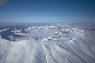
Geological Summary. The basaltic Okmok shield volcano forms the NE end of Umnak Island in the Aleutian Islands. The summit of the low, 35-km-wide volcano is cut by two overlapping 10-km-wide calderas formed during eruptions about 12,000 and 2,050 years ago when dacitic pyroclastic flows reached the coast. More than 60 tephra layers from Okmok have been found overlying the 12,000-year-old caldera-forming tephra layer. Numerous cones and lava domes are present on the flanks down to the coast, including the SE-flank Mount Tulik, which is almost 200 m higher than the caldera rim. Some of the post-caldera cones show evidence of wave-cut lake terraces; more recent cones were formed after the caldera lake, once 150 m deep, disappeared. Eruptions have been reported since 1805 from cinder cones within the caldera, where there are also hot springs and fumaroles.
Information Contacts: Alaska Volcano Observatory (AVO), a cooperative program of a) U.S. Geological Survey, 4200 University Drive, Anchorage, AK 99508-4667, USA (URL: http://www.avo.alaska.edu/), b) Geophysical Institute, University of Alaska, PO Box 757320, Fairbanks, AK 99775-7320, USA, and c) Alaska Division of Geological & Geophysical Surveys, 794 University Ave., Suite 200, Fairbanks, AK 99709, USA.