Report on Merapi (Indonesia) — October 2001

Bulletin of the Global Volcanism Network, vol. 26, no. 10 (October 2001)
Managing Editor: Richard Wunderman.
Merapi (Indonesia) Dome collapses and lava avalanches August-November; two unconfirmed deaths
Please cite this report as:
Global Volcanism Program, 2001. Report on Merapi (Indonesia) (Wunderman, R., ed.). Bulletin of the Global Volcanism Network, 26:10. Smithsonian Institution. https://doi.org/10.5479/si.GVP.BGVN200110-263250
Merapi
Indonesia
7.54°S, 110.446°E; summit elev. 2910 m
All times are local (unless otherwise noted)
Our last report (BGVN 26:07) covered activity from 14 February through 28 August 2001. The first portion of this report was provided by John Seach, who visited Merapi during 17-20 August 2001. The latter portion came from the Volcanological Survey of Indonesia (VSI); their reports discussed activity during late August through early November 2001.
Unconfirmed reports from volcano guides encountered at Babadan Observatory stated that two tourists were killed by dome collapse phenomena in early August after walking into the S-flank danger zone.
Activity was dominated by regular dome collapse and lava avalanches. On 17 August at 0735 an eruption of Merapi occurred, visible from the city of Yogyakarta. A dark brown plume was observed above the summit followed by a lava avalanche down the S side of the volcano. During the evening of 18 August, glowing avalanches were observed flowing down the SW side of the volcano at regular intervals. Runout distances were ~5 km.
On 19 August, observations were made from a location 220 m below the N-flank summit. Ascent to the summit area above the lava dome was not possible due to the continuing explosions of the dome. During the climb glowing avalanches continued down the SW flank. After dawn a white plume was continuously emitted to 200 m above the lava dome. About every 30 minutes there was an emission of light brown ash, indicating dome collapse. At 0930 burning vegetation was observed on the SW flank at an elevation of 1,400 m, presumably set alight by lava.
That evening, observations were made from Babadan Observatory on the SSW side of the volcano, 4 km from the summit (elevation 1,300 m). Between 2130 and 2330 there were 25 lava dome collapses. Lava was observed to extrude from the dome vertically and then collapse, producing thousands of glowing boulders that rolled 4 km down the flank (figure 23). The larger eruptions were accompanied by rumbling noises and earthquakes.
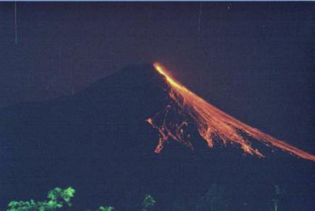 |
Figure 23. A night view of the incandescence seen after lava-dome collapse at Merapi on 19 August 2001. Photo taken from the Babadan Observatory on the SSW side of the volcano 4 km from the summit. Courtesy of John Seach. |
On the morning of 20 August a dense white plume was visible rising 300 m above the summit. Occasional brown emissions rolled down the SW slope indicating continuing dome collapse.
The Volcanological Survey of Indonesia (VSI) reported that during late August through at least 4 November seismic activity at Merapi was dominated by avalanche earthquakes (table 11). During the week of 27 August-2 September, one low-frequency earthquake was registered. Table 11 also summarizes a white, thin, low-pressure fumarolic plume reported at various heights above the volcano throughout the report period. Lava avalanches were ongoing, traveling mainly in the headwaters upstream of the Lamat river, with a maximum runout distance of 2.75 km (see table 11). On 8 October at 1729 a minor pyroclastic flow traveled ~2 km toward the Sat river; on 24 October, four minor pyroclastic flows again traveled 2 km toward the Sat and Senowo rivers. Despite heavy rain at times, no lahars were reported. Merapi remained at Alert Level 2 (on a scale of 1-4) throughout the 27 August-4 November report period. Fumarolic temperatures at the Gendel and Woro craters varied by ten's of degrees Celsius during 27 August through 4 November (table 12).
Table 11. A summary describing Merapi's volcanic seismicity, typical plumes, and lava avalanches during 27 August-4 November 2001. Courtesy of VSI.
| Date | Avalanche Earthquakes | Multiphase Earthquakes | Plume height above summit | Details of lava avalanches |
| 27 Aug-02 Sep 2001 | 588 | 10 | 50 m | Flowed down Senowo, Sat, Lamat, and Bebeng rivers with a maximum distance of 2.5 km towards the Sat and Lamat. |
| 03 Sep-09 Sep 2001 | 652 | 11 | 300 m | Ongoing, observed 36 times, dominantly traveled upstream of Sat and Lamat rivers, partly filling Senowo and Bebeng rivers. |
| 10 Sep-16 Sep 2001 | 588 | 2 | 450 m | Ongoing, dominantly traveled upstream of Lamat and Senowo rivers, reaching as far as 2.5 km away. |
| 17 Sep-23 Sep 2001 | 684 | 1 | 750 m | Ongoing, observed 51 times, dominantly upstream of Sat river but lesser parts traveled to Lamat, Senowo, and Bebeng rivers (maximum distance of 2.5 km). |
| 24 Sep-30 Sep 2001 | 756 | 3 | 350 m | Ongoing, traveled down to Sat, Lamat, and Senowo rivers (maximum distance of 2.5 km). |
| 01 Oct-07 Oct 2001 | 702 | 8 | 425 m | Ongoing, observed 59 times, dominantly to the upstream of Sat river, with a lesser part flowing down to Lamat and Senowo rivers (maximum distance of 2.5 km). |
| 08 Oct-14 Oct 2001 | 692 | 5 | 170 m | Ongoing, observed 53 times, dominantly to the upstream of Sat river, partly to Lamat and Senowo rivers (maximum distance of 2 km). |
| 15 Oct-21 Oct 2001 | 800 | 7 | 575 m | Ongoing, observed 103 times, dominantly towards the upstream of Sat river, and partly to the Lamat and Senowo rivers (maximum distance of 2.75 km). |
| 22 Oct-28 Oct 2001 | 790 | -- | 750 m | Ongoing, observed 121 times, dominantly towards the upstream of Sat river, and partly to the upstream of Lamat and Senowo rivers (maximum distance of 2.75 km). |
| 29 Oct-04 Nov 2001 | 786 | -- | 480 m | Ongoing, observed 124 times, dominantly towards the upstream of Sat river and partly to the upstream of Lamat and Senowo rivers (maximum distance of ~2.8 km). |
Table 12. Temperatures reported at Gendel and Woro craters of Merapi during 27 August through 28 October. No data collected during 1-14 October. Courtesy of VSI.
| Date | Gendol crater | Woro crater |
| 03-09 Sep 2001 | 590-595°C | 461-465°C |
| 10-16 Sep 2001 | 589-606°C | -- |
| 17-23 Sep 2001 | 602-617°C | -- |
| 24-30 Sep 2001 | 598-618°C | -- |
| 15-21 Oct 2001 | 566-571°C | 612°C |
| 22-28 Oct 2001 | 561-575°C | -- |
Geological Summary. Merapi, one of Indonesia's most active volcanoes, lies in one of the world's most densely populated areas and dominates the landscape immediately north of the major city of Yogyakarta. It is the youngest and southernmost of a volcanic chain extending NNW to Ungaran volcano. Growth of Old Merapi during the Pleistocene ended with major edifice collapse perhaps about 2,000 years ago, leaving a large arcuate scarp cutting the eroded older Batulawang volcano. Subsequent growth of the steep-sided Young Merapi edifice, its upper part unvegetated due to frequent activity, began SW of the earlier collapse scarp. Pyroclastic flows and lahars accompanying growth and collapse of the steep-sided active summit lava dome have devastated cultivated lands on the western-to-southern flanks and caused many fatalities.
Information Contacts: John Seach, PO Box 16, Chatsworth Island, NSW, 2469, Australia (URL: http://www.volcanolive.com/); Dali Ahmad, Volcanological Survey of Indonesia (VSI), Jalan Diponegoro No.57, Bandung 40122, Indonesia (URL: http://www.vsi.esdm.go.id/).