Report on Karangetang (Indonesia) — October 2001
Bulletin of the Global Volcanism Network, vol. 26, no. 10 (October 2001)
Managing Editor: Richard Wunderman.
Karangetang (Indonesia) April-October activity includes lava flows, lava avalanches, and ash plumes
Please cite this report as:
Global Volcanism Program, 2001. Report on Karangetang (Indonesia) (Wunderman, R., ed.). Bulletin of the Global Volcanism Network, 26:10. Smithsonian Institution. https://doi.org/10.5479/si.GVP.BGVN200110-267020
Karangetang
Indonesia
2.781°N, 125.407°E; summit elev. 1797 m
All times are local (unless otherwise noted)
The frequent, but spasmodic, activity witnessed during 2000 and the early part of 2001 at Karangetang quieted somewhat between mid-February and mid-April, although the Alert Level remained at 2 (on a scale of 1-4). During late April and early May, the Volcanological Survey of Indonesia (VSI) reported lava flowing from the crater. Lava avalanches that originated at the end of the lava flow traveled 750 m to the Nanitu River. A likely ash plume rose 50-300 m above the main crater and a steam cloud from Crater II rose 200 m above the summit. Plume illumination was visible 25-75 m above the volcano.
Volcanic activity continued at high levels after eruptions on 25 and 29 June. During early July, seismographs registered small explosions, avalanches, and an average of 33 earthquakes/day. A gray plume was emitted. As a result of this increased activity, the Alert Level was raised to 3. During the remainder of July and August, explosions, avalanches, and earthquakes continued to dominate seismicity. During 9-15 July, there were 572 explosions, 451 earthquakes, and continuous lava avalanches; one avalanche traveled 2.5 km down the Keting River and lava flowed 750 m down the Kahetang River. On 10 August, cold lahars crossed roads as they traveled down the Batu Awang and the Kahetang Rivers.
Similar seismic activity, lava flows, and lava avalanches continued into mid-September. On 9 September, a pyroclastic flow traveled as far as 750 m from the main crater to the Batang River (West Siau). During 10-16 September, the number of lava flows and avalanches decreased. Lava flowed 1.5 km down the Kahetang and Keting rivers, and avalanches extended 1 km. Small explosions and earthquakes continued, while emissions of steam and possibly ash at the N main crater rose to 0.5 km above the summit. During the rest of September, seismicity decreased, and lava flows and avalanches were rare.
Deep volcanic earthquakes increased during early October, and during 1-2 October incandescent lava avalanches traveled from the main crater and steam plumes rose 600 m above the main crater and 50-150 m above Crater II. Plume illumination was observed to 50 m above the volcano. The Alert Level was reduced to 2 because of the decrease in deep earthquake activity that occurred the following week.
During 22-28 October, the number of deep volcanic earthquakes increased but no seismicity associated with eruptive activity was recorded. White plumes continued to rise above the main crater and Crater II, plume illumination was observed above the crater, and multi-phase earthquakes, associated with lava-dome growth, were detected. On 29 October a minor explosion from Crater IV produced a gray cloud that rose 1.5 km above the crater. As of the end of October, the Alert Level remained at 2.
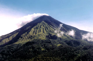
Geological Summary. Karangetang (Api Siau) volcano lies at the northern end of the island of Siau, about 125 km NNE of the NE-most point of Sulawesi. The stratovolcano contains five summit craters along a N-S line. It is one of Indonesia's most active volcanoes, with more than 40 eruptions recorded since 1675 and many additional small eruptions that were not documented (Neumann van Padang, 1951). Twentieth-century eruptions have included frequent explosive activity sometimes accompanied by pyroclastic flows and lahars. Lava dome growth has occurred in the summit craters; collapse of lava flow fronts have produced pyroclastic flows.
Information Contacts: Dali Ahmad, Volcanological Survey of Indonesia (VSI), Jalan Diponegoro No. 57, Bandung 40122, Indonesia (URL: http://www.vsi.esdm.go.id/).

