Report on Galeras (Colombia) — October 2001

Bulletin of the Global Volcanism Network, vol. 26, no. 10 (October 2001)
Managing Editor: Richard Wunderman.
Galeras (Colombia) Volcano-tectonic earthquakes during July through late September 2001
Please cite this report as:
Global Volcanism Program, 2001. Report on Galeras (Colombia) (Wunderman, R., ed.). Bulletin of the Global Volcanism Network, 26:10. Smithsonian Institution. https://doi.org/10.5479/si.GVP.BGVN200110-351080
Galeras
Colombia
1.22°N, 77.37°W; summit elev. 4276 m
All times are local (unless otherwise noted)
Our last report (BGVN 26:05) discussed the low-level seismicity and eruptive activity observed at Galeras during April 2000-March 2001. During July through late September 2001, the greatest seismic energy contribution (1.7 x 10¹⁵ erg) resulted from 70 volcano-tectonic earthquakes. Epicenters were concentrated S and NE of the volcano, and some were felt by local residents. The largest VT events, an M 3 on 22 August (6 km depth) and an M 2 on 13 September (8 km depth), were felt in Pasto and Jenoy.
On 30 September, an M 4 tectonic earthquake centered ~12-18 km S of the volcano was felt in Pasto and some towns toward Nariño, 70 km SE of Galeras. An M 2 aftershock registered seven hours later. It was also felt in Pasto and some towns near the epicentral zone (figure 96).
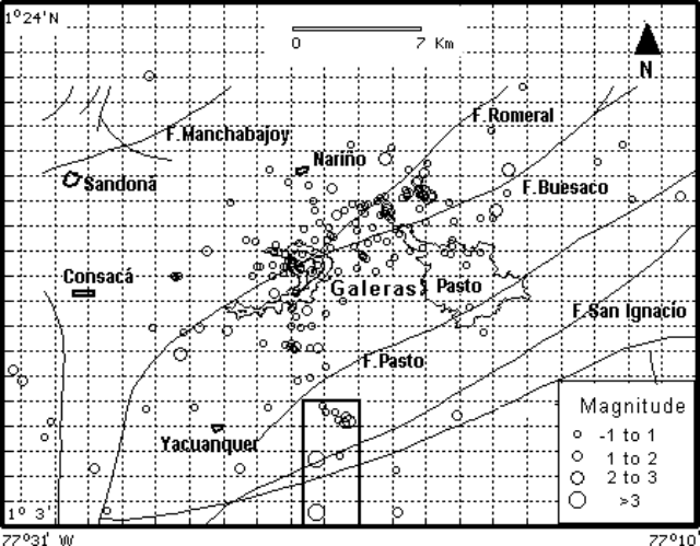 |
Figure 96. Map view showing volcano-tectonic earthquakes registered at Galeras during July-September 2001. The square shows the approximate location of the sequence of the tectonic earthquakes on 30 September. The breached caldera rim at Galeras is indicated; other names refer to local cities and villages. Courtesy of OVSP. |
On 24 August, a gas emission produced a spasmodic tremor episode that lasted ~5 minutes, followed by some long-period (LP) events (figure 97). The tremor's dominant frequencies were between 2and 5 Hz. The LP events had frequencies less than 3 Hz. Real-time temperature monitoring of Deformes fumarole (SW of the active crater) showed stability, in the range 92-94°C (figure 98).
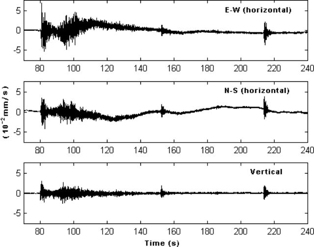 |
Figure 97. Digital record of the seismic signal registered at Galeras at 1155 UTC on 24 August 2001. The signal was received at Anganoy station (0.9 km SE of the active crater). The vertical scale on these records shows ground velocity. Courtesy of OVSP. |
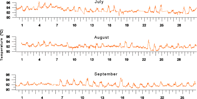 |
Figure 98. Digital temperature logs taken at Deformes fumarole at Galeras during July-September 2001. Courtesy of OVSP. |
Geological Summary. Galeras, a stratovolcano with a large breached caldera located immediately west of the city of Pasto, is one of Colombia's most frequently active volcanoes. The dominantly andesitic complex has been active for more than 1 million years, and two major caldera collapse eruptions took place during the late Pleistocene. Long-term extensive hydrothermal alteration has contributed to large-scale edifice collapse on at least three occasions, producing debris avalanches that swept to the west and left a large open caldera inside which the modern cone has been constructed. Major explosive eruptions since the mid-Holocene have produced widespread tephra deposits and pyroclastic flows that swept all but the southern flanks. A central cone slightly lower than the caldera rim has been the site of numerous small-to-moderate eruptions since the time of the Spanish conquistadors.
Information Contacts: Patricia Ponce, Observatorio Vulcanológico y Sismológico de Pasto (OVSP), INGEOMINAS, Carrera 31, 18-07 Parque Infantil, P.O. Box 1795, Pasto, Colombia (URL: https://www2.sgc.gov.co/volcanes/index.html).