Report on Yasur (Vanuatu) — January 2002

Bulletin of the Global Volcanism Network, vol. 27, no. 1 (January 2002)
Managing Editor: Richard Wunderman.
Yasur (Vanuatu) Mild eruptive phase ends and leads to a vigorous phase in December 2001; seismic data
Please cite this report as:
Global Volcanism Program, 2002. Report on Yasur (Vanuatu) (Wunderman, R., ed.). Bulletin of the Global Volcanism Network, 27:1. Smithsonian Institution. https://doi.org/10.5479/si.GVP.BGVN200201-257100
Yasur
Vanuatu
19.532°S, 169.447°E; summit elev. 361 m
All times are local (unless otherwise noted)
Following 22 months of mild eruptive activity (BGVN 26:11), at the end of October 2001 on-site volcanologists observed the beginning of a more vigorous eruptive phase. The phase's progressive onset was also monitored seismically, which revealed an initial cycle of substantial activity that developed during the first half of December (figure 27). This was followed by a calmer interval, 14-25 December, after which a new burst of activity took place.
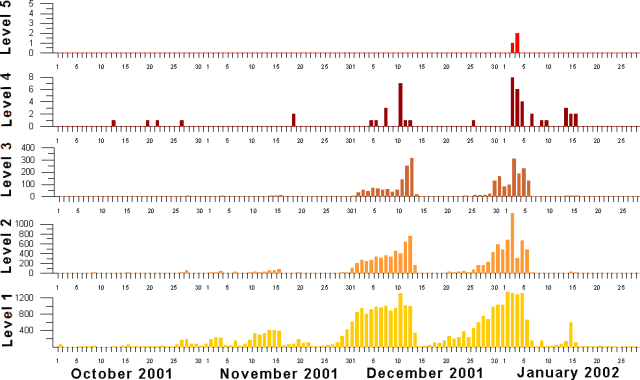 |
Figure 27. Seismicity recorded at Yasur during 1 October 2001 through 31 January 2002. Levels 1-5 have been defined by a signal-processing algorithm (see text). The units on the vertical axes are counts at the various levels. The two level-5 events correspond to large tectonic earthquakes. Courtesy of Michel Lardy, IRD. |
The seismic counts at Yasur (figure 27) can be explained as follows. A geophone is connected to an amplifier that generates signals in response to rapid vertical ground-movements. When the system's output signal (1-20 Hz) crosses a predefined threshold 8 times, the contents of the memory of the counter keyed to that particular threshold are increased by one. For a new count to begin, there has to be an interruption of the signal of at least 2 seconds. The permanent apparatus installed at Yasur for measurement of seismic variation is set to measure across 5 such thresholds, corresponding to an amplitude of just a few micrometers (level 1) to over 300 µm (level 5). The first four thresholds (levels) variously reflect Yasur's state of Strombolian activity.
At levels 1 and 2, one can observe hundreds, sometimes thousands, of seismic counts per day. During periods of high activity, paradoxically, one notes a lessening of the number of these counts, either because the counters are saturated, or because the background noise remains above the set threshold. In contrast, level 3, gives a representative idea of the volcano's daily activity: A count in the two-digit range indicates low activity; a daily count in the hundreds indicates high or even very high activity. For level 4, a few counts per day indicates high activity (a status of type 2 on the local hazard map), and when in excess of 10 counts per day, very high activity.
Regarding level 5-from the time since recording began in October 1993 to date-only major regional earthquakes have generated such high-amplitude signals. The counts for large earthquakes do not fully represent the assigned momement-magnitudes. That is the case here, for the main shock of the large tectonic earthquake on 2 January (M 7.2) attained fewer counts than the aftershock (M 6.6, figure 27).
A visit to the crater area on 31 December revealed that the majority of ash emission and ballistic projectiles were limited to area C (see map in BGVN 26:11) and that a vent of 20-30 m diameter, dormant at the time of earlier visits, had formed in area A (figure 28).
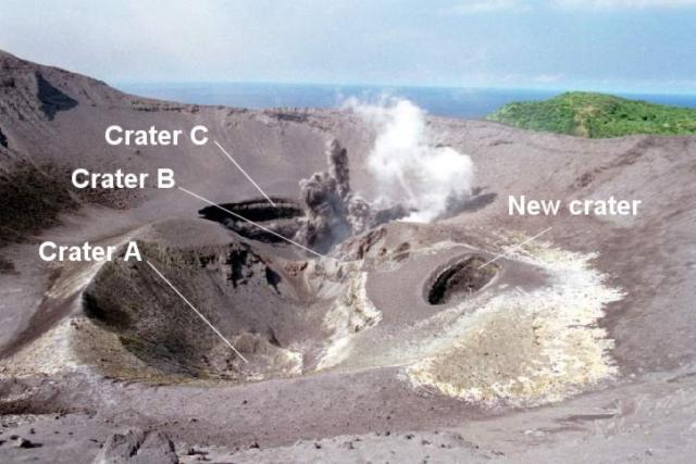 |
Figure 28. A picture taken of the area within Yasur's main crater showing smaller inner craters ("areas") A, B, C, and a new crater, as seen 31 December 2001. Note the small plumes coming from crater C. Copyrighted photo by S. Wallez. |
Observers witnessed Strombolian eruptions on 29, 30, and 31 December 2001 (figure 29). This activity was accompanied by considerable ash falling in a narrow band over the NE coastal area of the island. Close to a thousand residents suffered the effects of the ashfall, which also negatively impacted subsistence agriculture and the local collection of rainfall as a source of fresh water.
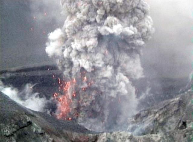 |
Figure 29. Details of an explosion in Yasur's area C on 31 December 2001. This photo is one of a series taken at half-second intervals. Copyrighted photo by S. Wallez. |
High-magnitude earthquakes. On 2 and 3 January 2002 large tectonic earthquakes struck over 200 km N of Tanna Island (Mw 7.2 and 6.6 respectively). They were felt by the population of Tanna, and recorded by the seismic monitoring station at level 5 (figure 27). Subsequent records showed a considerable weakening of volcanic activity a few days following the earthquake, similar to the pattern observed after the (1-14 December 2001 cycle). It is common for high-magnitude earthquakes (M > 6) near the center of the Vanuatu island group to be felt in Tanna, over 200 km away. To date, after 8 years of continuous monitoring (BGVN 26:11), no connection has been observed between such earthquakes and shifts towards more hazardous behavior at Yasur.
Geological Summary. Yasur has exhibited essentially continuous Strombolian and Vulcanian activity at least since Captain Cook observed ash eruptions in 1774. This style of activity may have continued for the past 800 years. Located at the SE tip of Tanna Island in Vanuatu, this pyroclastic cone has a nearly circular, 400-m-wide summit crater. The active cone is largely contained within the small Yenkahe caldera, and is the youngest of a group of Holocene volcanic centers constructed over the down-dropped NE flank of the Pleistocene Tukosmeru volcano. The Yenkahe horst is located within the Siwi ring fracture, a 4-km-wide open feature associated with eruption of the andesitic Siwi pyroclastic sequence. Active tectonism along the Yenkahe horst accompanying eruptions has raised Port Resolution harbor more than 20 m during the past century.
Information Contacts: Janette Tabbagh, Université Paris VI, UMR 7619, Coordination des Rechershes Volcanologiques (CRV), 4 Place Jussieu, 75252 Paris Cedex 05, France; Michel Lardy, Institut de Recherche pour le Développement (IRD), CRV, BP A 5 Nouméa, Nouvelle Calédonie; Sandrine Wallez and Douglas Charley, Department of Geology, Mines and Water Resources, PMB 01, Port-Vila, Vanuatu.