Report on Cerro Negro (Nicaragua) — February 2002
Bulletin of the Global Volcanism Network, vol. 27, no. 2 (February 2002)
Managing Editor: Richard Wunderman.
Cerro Negro (Nicaragua) Increased tremor and a new fumarole
Please cite this report as:
Global Volcanism Program, 2002. Report on Cerro Negro (Nicaragua) (Wunderman, R., ed.). Bulletin of the Global Volcanism Network, 27:2. Smithsonian Institution. https://doi.org/10.5479/si.GVP.BGVN200202-344070
Cerro Negro
Nicaragua
12.506°N, 86.702°W; summit elev. 728 m
All times are local (unless otherwise noted)
During 19-20 February 2002 a slight increase in seismic tremor and some very small earthquakes were registered by a seismic station at Cerro Negro. The increase in tremor varied in amplitude and lasted for 12 hours, from 2300 on 19 February until 1100 on 20 February. Tremor continued to occur at very low (normal) levels for the rest of the day on 20 February until 22 February.
On the morning of 20 February, representatives from Instituto Nicaragüense de Estudios Territoriales (INETER) visited the volcano and made observations of the main crater and small cones that were formed during the 1999 eruption (BGVN 24:11). Compared to a visit on a few days earlier, there were no major changes observed except for the normal intra-crater movements found along collapses, fractures, and small landslides. The visitors noted one small recent landslide and a new fumarole at the E end of the crater. Fumarole temperatures in the main crater were slightly increased compared to previous visits (reaching 409°C, according to news reports). Some fumaroles contained larger volumes of sulfur precipitates and sublimates than seen previously.
News articles stated that on 20 February the Civil Defense reported that a landslide had occurred at Cerro Madre that was ~80-100 m long and 45 m wide.
By 23 February, INETER suggested that the increased tremor observed on 21 February may have been associated with increased gas emissions related to the formation of the new fumarole. Since no major volcanic activity was observed, INETER reported that there was no cause for alarm and no imminent danger for populations bordering the volcano, but that visitors or tourists who enter the crater should be prepared for sudden, unannounced, and possibly dangerous events like gas explosions and landslides.
During 26 February-11 March 2002 scientists from Instituto Tecnológico y de Energías Renovables (ITER) and INETER studied ground temperature, and diffuse H20, CO2, and H2S degassing. The team surveyed 175 sampling sites over an area of ~0.5 km2 . Soil CO2 and H2S flux values ranged from 0.3 to 28,000 g/m2 d, and from 1 to 17,000 mg/m2 d, respectively. Soil temperatures at 40 cm depth ranged from 22 to 453°C, while air temperature ranged from 21 to 46°C. Soil Hg0 gas was also analyzed in situ; its concentration reached up to 204 mg/m3.
Compared to the 2002 survey, the one in 1999 showed similar, though somewhat higher CO2 values, up to 35,000 g/m2 d, and a wider range of ground temperatures, 16 to 707°C (Salazar and others, 2001). The 1999 survey was carried out three months after the most recent eruption at Cerro Negro (BGVN 24:11).
General Reference. Salazar and others, 2001, Diffuse emission of carbon dioxide from Cerro Negro volcano, Nicaragua, Central America: Geophysical Research Letters, v. 28, p. 4275-4278.
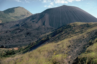
Geological Summary. Nicaragua's youngest volcano, Cerro Negro, was created following an eruption that began in April 1850 about 2 km NW of the summit of Las Pilas volcano. It is the largest, southernmost, and most recent of a group of four youthful cinder cones constructed along a NNW-SSE-trending line in the central Marrabios Range. Strombolian-to-subplinian eruptions at intervals of a few years to several decades have constructed a roughly 250-m-high basaltic cone and an associated lava field constrained by topography to extend primarily NE and SW. Cone and crater morphology have varied significantly during its short eruptive history. Although it lies in a relatively unpopulated area, occasional heavy ashfalls have damaged crops and buildings.
Information Contacts: Wilfried Strauch, Dirección General de Geofísica, Instituto Nicaragüense de Estudios Territoriales (INETER), Apartado 1761, Managua, Nicaragua (URL: http://www.ineter.gob.ni/); Nemesio M. Pérez and Gladys Melián, Inés Galindo, Environmental Research Division, Instituto Tecnológico y de Energías Renovables (ITER), 38611 Granadilla, Tenerife, Canary Islands, Spain; El Nuevo Diario (URL: http://www.elnuevodiario.com.ni/); La Prensa (URL: http://www-ni.laprensa.com.ni/).