Report on Hachijojima (Japan) — July 2002
Bulletin of the Global Volcanism Network, vol. 27, no. 7 (July 2002)
Managing Editor: Richard Wunderman.
Hachijojima (Japan) Seismic swarms during August 2002
Please cite this report as:
Global Volcanism Program, 2002. Report on Hachijojima (Japan) (Wunderman, R., ed.). Bulletin of the Global Volcanism Network, 27:7. Smithsonian Institution. https://doi.org/10.5479/si.GVP.BGVN200207-284050
Hachijojima
Japan
33.137°N, 139.766°E; summit elev. 854 m
All times are local (unless otherwise noted)
The Japanese Meteorological Agency (JMA) reported that at around 1600 on 13 August 2002 seismic swarms began on Hachijo-jima island (figure 1). The island lies ~300 km S of Tokyo in the Izu island chain. A total of 16 earthquakes were felt by 1700 on 15 August. Hypocenters were located ~2 km off the W shore of the central part of the island, at depths of 5-15 km (according to seismic-wave velocity models) (figure 2). The earthquakes deepened and started migrating to the N, in the direction of Nishi-yama, on the morning on 15 August. Five seismic stations are located on the inhabited island.
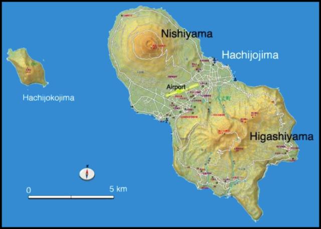 |
Figure 1. Map showing the elongated, NW-SE-trending Hachijo-jima island, consisting of two small Quaternary stratovolcanoes, Higashi-yama to the SE and Nishi-yama to the NW. The small volcanic island of Ko-jima lies several kilometers to the W of Hachijo-jima. Courtesy of Volcano Research Center. |
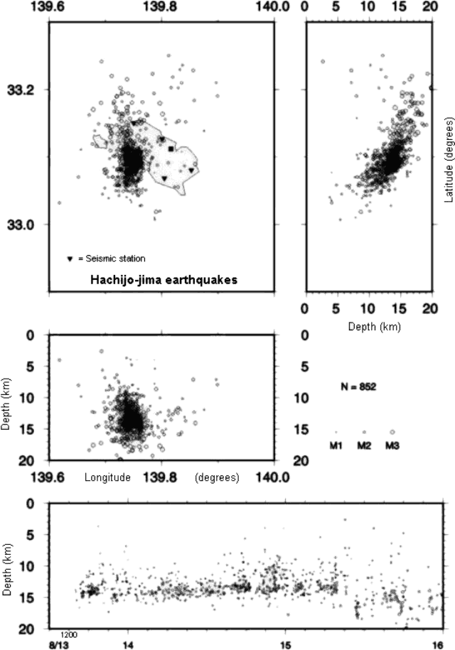 |
Figure 2. Hypocenters of volcanic earthquakes at Hachijo-jima during 13-15 August 2002 (as of 2000 on 15 August). Courtesy of Shin'ichi Sakai, JMA. |
On 16 August JMA reported that high seismicity continued at Hachijo-jima volcano, when volcanic tremor-like waves were recorded. JMA reported that the hourly number of earthquakes had been over 20 since the evening of 13 August; the peak occurred on the morning of 15 August (~250 earthquakes per hour). As of 1500 on 16 August, 22 earthquakes had been felt. Seismic activity began to decrease during the evening of 16 August. JMA reported that during 16-17 August, less than 20 earthquakes occurred per hour. JMA installed two seismometers temporarily on the island on 17 August. JMA released a statement saying that the present seismic activity may continue at the same level for some time without an eruption. The Geographical Survey Institute reported that the GPS station located in the center of the island had migrated 5-6 cm to the E and had been uplifted 10 cm by 1500 on 16 August.
Seismicity around Hachijo-jima decreased by 21 August. Since the afternoon of 20 August, less than 10 earthquakes occurred per hour. Hypocenters had migrated to the NW from the original site of earthquake concentration, advancing parallel to the long axis of the island. Low-frequency earthquakes continued on 21 August; hypocenters were located near the first swarms of 13-15 August.
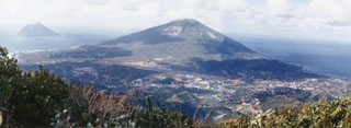
Geological Summary. Hachijojima, in the central Izu Islands about 300 km S of Tokyo, consists of two small Quaternary dominantly basaltic stratovolcanoes forming an elongated NW-SE-trending island. The eroded Pleistocene-to-Holocene Higashiyama volcano occupies the SE end of the 14-km-long island. The symmetrical Holocene Nishiyama volcano the NW end has cones on the SE flank. The small volcanic island of Kojima lies several kilometers W of Hachijojima. Growth of Higashiyama began several tens of thousands of years ago, and included the formation of two small calderas. The initial submarine and early subaerial eruptions of Nishiyama took place from 10,000 to 8,000 years before present (BP). Its latest major activity, from the early Holocene until about 4,000 BP, was restricted to flank eruptions. Eruptions recorded since the 15th century have been restricted to the summit of Nishiyama and a submarine vent of unknown location.
Information Contacts: Hitoshi Yamasato, Japanese Meteorological Agency (JMA), Volcanological Division, 1-3-4 Ote-machi, Chiyoda-ku, Tokyo 100, Japan (URL: http://www.jma.go.jp/); Shin'ichi Sakai, Volcano Research Center (VRC), Earthquake Research Institute (ERI), University of Tokyo, 113-0032 1-1-1, Yayoi, Bunkyo-ku, Tokyo (URL: http://www.eri.u-tokyo.ac.jp/VRC/index_E.html); Geographical Survey Institute (GSI), Kitasato 1, Tsukuba Ibaraki, 305-0811 Japan (URL: http://www.gsi.go.jp/).