Report on Karymsky (Russia) — September 2002
Bulletin of the Global Volcanism Network, vol. 27, no. 9 (September 2002)
Managing Editor: Richard Wunderman.
Karymsky (Russia) 3-km-high plumes, seismicity, and three new lava flows through September 2002
Please cite this report as:
Global Volcanism Program, 2002. Report on Karymsky (Russia) (Wunderman, R., ed.). Bulletin of the Global Volcanism Network, 27:9. Smithsonian Institution. https://doi.org/10.5479/si.GVP.BGVN200209-300130
Karymsky
Russia
54.049°N, 159.443°E; summit elev. 1513 m
All times are local (unless otherwise noted)
Frequent plumes (including 15 April and 9 July ash clouds to 3.0 km above the volcano), a new intracrater cone, and a 1.3-km-long lava flow were seen during 1 January-9 July 2002 (BGVN 27:03 and 27:06). This report first highlights events described in 10 July-September 2002 updates. During this interval Karymsky produced 3-km-tall plumes, restless seismicity, and three new lava flows. Next, a separate section of this report presents photos of Karymsky and adjacent Akademia Nauk caldera taken in September 2000 and in May 2002. This report also cites a fundamental reference volume on the topic of the 1996 eruption, Fedotov (1998), which includes a preface and ten papers.
Activity during 10 July-September 2002. Seismicity during this interval generally stood well above background levels, very often at a value of ~10 earthquakes per hour. During nearly every week of the reporting interval, geophysicists suggested that the character of the seismicity might indicate weak ash-and-gas explosions and avalanches. Weak thermal anomalies were often observed on AVHRR satellite imagery and, in the majority of cases, no ash was detected. In contrast, satellite imagery on 25 July indicated a possible, small, SW-directed ash plume. On 26 July, a thermal anomaly reached 2 pixels in size.
During 27 July-2 August, local, shallow seismic events decreased, dropping from 250 to 150 events per day. During 30 August-6 September and 13-24 September there were 200-300 local shallow earthquakes occurring per day (compared to 150-250 per day in August). In early September estimates suggested that explosions rose ~1 km above the summit.
Observations on 8 September revealed three new small lava flows on the volcano's S and SE slopes. On satellite imagery a thermal anomaly was visible but ash was not. The character of the seismicity indicated ash-and-gas explosions rising ~1 km above the volcano and gas blow-outs. On 16 September at 1217 a short-lived explosion created an ash-and-gas plume; observers on an aircraft aloft estimated the plume top's height at ~3 km altitude.
Photographs and brief retrospective on the 1996 eruption. Figures 10 and 11 provide overviews of the Karymsky stratovolcano (also written as Pra-Karymsky) and adjacent areas to the S on 26 September 2000 and 10 May 2002 respectively. Both these aerial photos were provided by Victor Ivanov (Russian Academy of Sciences). The former was taken ~4 years after the complex 1996 eruption (see BGVN 21:01-21:03 and 21:05; and Fedotov, 1998).
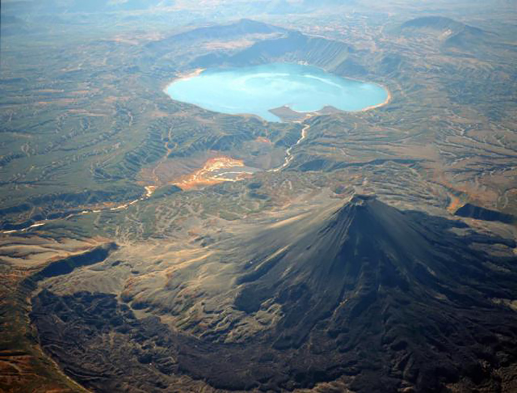 |
Figure 10. An aerial photo taken on 26 September 2000 looking towards the SSE and showing Karymsky stratovolcano (cone on the right), the low-lying portion of Akademia Nauk caldera containing Karymsky lake (in the upper center of the photo), Karymsky river (bright, light-colored zone cutting diagonally across the center and left), and Belyankin volcano (arc-shaped, in the upper-right corner). Prominent cliffs, part of the N-facing amphitheater of Dvor volcano, curve across the terrain well outboard of the stratovolcano (lower left-hand margin). The Karymsky river drains the lake from an outlet at the head of a conspicuous bay. The distance from the cone's summit to the lake's nearest margin is ~ 5 km. Courtesy of Victor Ivanov. |
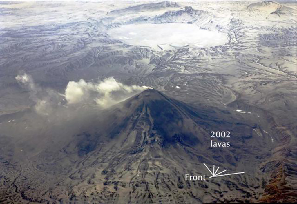 |
Figure 11. An aerial photo with Karymsky stratovolcano in the foreground, shot looking towards the S on 10 May 2002. Snow blankets considerable areas and ice covers Karymsky lake. During 1996-2000 many lava flows covered the stratovolcano's SW slope. On 10 May there were fresh andesitic lavas descending the W flank reaching ~ 1.3 km in length and ~ 300 m in maximum width (labeled "2002 lavas" and "Front"). Haze in this photo is partly due to erupted ash suspended in the atmosphere. A separate photo the same day captured Karymsky with a billowing, light-colored plume (figure 9 above). Courtesy of Victor Ivanov. |
In overview, that eruption consisted of a 1 January 1996 earthquake swarm (with events to M 6.9) followed a day later with simultaneous eruptions from two vents 6 km apart, one at the stratovolcano's summit, the other at Akademia Nauk caldera in the N end of Karymsky lake. The latter consisted of a submarine phreatomagmatic eruption that deposited a low conical ring composed of pyroclastics. The subaerial portion of those deposits encircled the vent forming a ~600-m-wide crater in the cone's center. The cone also extended to the lake shore, thus forming a peninsula. The eruptive event included or was associated with base surges, tsunamis, surface ruptures, and secondary eruptions on the new peninsula. The eruption also left the lake with pH of 3.2 and its outlet into the Karymsky river obstructed by the new deposits. Several months later the new deposits eroded, resulting in massive mudflows down the Karymsky river. At the submarine vent eruptive products were predominantly basaltic; some fine ash was andesitic; late-stage rhyolites occasionally formed inclusions within basalts and bombs with basaltic jackets.
The photos were taken from perspectives on the volcano's N side. Several months after the dam-breaking event, the partly eroded pyroclastic deposits took the form of a squat U-shaped peninsula with two arms extending hundreds of meters into the lake. The circular segment along the middle of the peninsula's shoreline is part of the original cone's arcuate rim. Towards the left of the peninsula lies a conspicuous bay that leads to the outflow channel and the Karymsky river (the latter is most apparent on figure 10). Figure 11 shows that two years later the pyroclastic deposits in the lake more closely resemble lines rather than broad zones due to the partial cover of ice and snow.
The 1996 eruption at Karymsky and the Akademia Nauk caldera may have been a response to the injection of fresh basaltic magma from a deeper magmatic source. Later stages of the eruption at Karymsky have continued more than 6 years through this reporting interval.
During the underwater eruption in 1996 all of the lake's ice was broken and melted. Along the lake shore many new hot springs appeared. After the underwater eruption on the bottom of the lake many sources of heat and degassing appeared. The eruption triggered an ecological catastrophe during which all fish in the lake died.
During the winter 1996-1997 the water of the lake remained warm and devoid of ice. Usually ice completely disappears only in June or July. Lake ice returned in subsequent winters. Figure 10 (26 September 2000) shows light-colored patterns on the lake's surface that signify the presence of local ice accumulating there with the approach of winter. Figure 11 documents the dominance of ice on Karymsky lake's surface, still intact from the previous winter when photographed. The May 2002 lake surface also contained some ice-free zones. Their presence suggested the continued existence of post-eruptive heat sources on the lake bottom. These areas were possibly rich in algae and micro-organisms.
Reference. S. A. Fedotov, S.A., 1998, The 1996 eruption in the Karymsky volcanic center and related events: Special issue of Volcanology and Seismology, v. 19, no. 5, p. 521-767 (L.N. Rykunov, Ed. in Chief; Preface and 10 papers; English translation), Gordon & Breach Science Publishers (ISBN 0742-0463).
Geological Summary. Karymsky, the most active volcano of Kamchatka's eastern volcanic zone, is a symmetrical stratovolcano constructed within a 5-km-wide caldera that formed during the early Holocene. The caldera cuts the south side of the Pleistocene Dvor volcano and is located outside the north margin of the large mid-Pleistocene Polovinka caldera, which contains the smaller Akademia Nauk and Odnoboky calderas. Most seismicity preceding Karymsky eruptions originated beneath Akademia Nauk caldera, located immediately south. The caldera enclosing Karymsky formed about 7600-7700 radiocarbon years ago; construction of the stratovolcano began about 2000 years later. The latest eruptive period began about 500 years ago, following a 2300-year quiescence. Much of the cone is mantled by lava flows less than 200 years old. Historical eruptions have been vulcanian or vulcanian-strombolian with moderate explosive activity and occasional lava flows from the summit crater.
Information Contacts: Olga Chubarova, Kamchatka Volcanic Eruptions Response Team (KVERT), Institute of Volcanic Geology and Geochemistry, Piip Ave. 9, Petropavlovsk-Kamchatsky, 683006, Russia; Victor Ivanov, Institute of Volcanology Far East Division, Russian Academy of Sciences, Petropavlovsk-Kamchatsky, 683006, Russia.