Report on Rabaul (Papua New Guinea) — January 2003

Bulletin of the Global Volcanism Network, vol. 28, no. 1 (January 2003)
Managing Editor: Edward Venzke.
Rabaul (Papua New Guinea) Continued ash eruptions from three vents at Tavurvur
Please cite this report as:
Global Volcanism Program, 2003. Report on Rabaul (Papua New Guinea) (Venzke, E., ed.). Bulletin of the Global Volcanism Network, 28:1. Smithsonian Institution. https://doi.org/10.5479/si.GVP.BGVN200301-252140
Rabaul
Papua New Guinea
4.2459°S, 152.1937°E; summit elev. 688 m
All times are local (unless otherwise noted)
During mid-December 2002 through early February 2003, eruptions at Tavurvur continued from three vents at different times. The eruptions were characterized by slow, thick convoluted ash plumes occurring at irregular intervals and rising about several hundred to thousands of meters above the summit. Occasionally they became forceful. Throughout the report period light to pale gray ash plumes drifted in various directions, resulting in ashfall in the town of Rabaul, Matupit Island, Malaguna village, and other areas. During 20-27 January ash emissions were associated with discrete short-duration seismic events and slightly longer duration events. The former event types were pronounced during 20-27 January, but on 26 and 27 January seismicity changed to the low-amplitude medium-to-long duration type.
Generally, the seismicity fluctuated at low-to-moderate levels. A period of harmonic tremor was recorded on the morning of 18 December 2002. That day, the Rabaul Volcano Observatory (RVO) reported that the gaps between emissions seemed to have lengthened over the previous 24 hours. During 19-20 December, occasional larger explosions showered the flanks with rocks. Following the explosions ash-poor plumes were gently emitted from the whole area of the Northern Crater. During 20-23 December there was a slight increase in the number of volcanic earthquakes due to more ash emissions. The increase in volcanic earthquakes tapered off over the next few days.
Ground deformation measurements from real-time GPS showed no significant changes. On 24 January RVO reported that the electronic tiltmeter had been showing a slow inflation during the previous 2 months. That trend ceased by 27 January, when ground-deformation measurements from real-time GPS changed to show an inflationary trend through 2 February. Long-duration, low-amplitude earthquakes occurred through at least 10 February.
MODVOLC Thermal Alerts, 2001-2002. During 2001 and 2002, MODIS alerts occurred only during April-September 2001 and June-December 2002. These anomalies were always represented by a single alert-pixel, except for 26 May 2001, 4 July 2001, and 22 October 2002, which each had two alert-pixels. The maximum alert ratio was on 4 July 2001 when it reached -0.26. The center coordinates of all the alert-pixels plot within 1 km of each other, in a cluster centered ~1 km W of Tavurvur (figure 37), which is the only site of known activity during this period. This high degree of repeatability offset from the likely seat of the anomaly at the summit vent suggests a systematic error in geolocation.
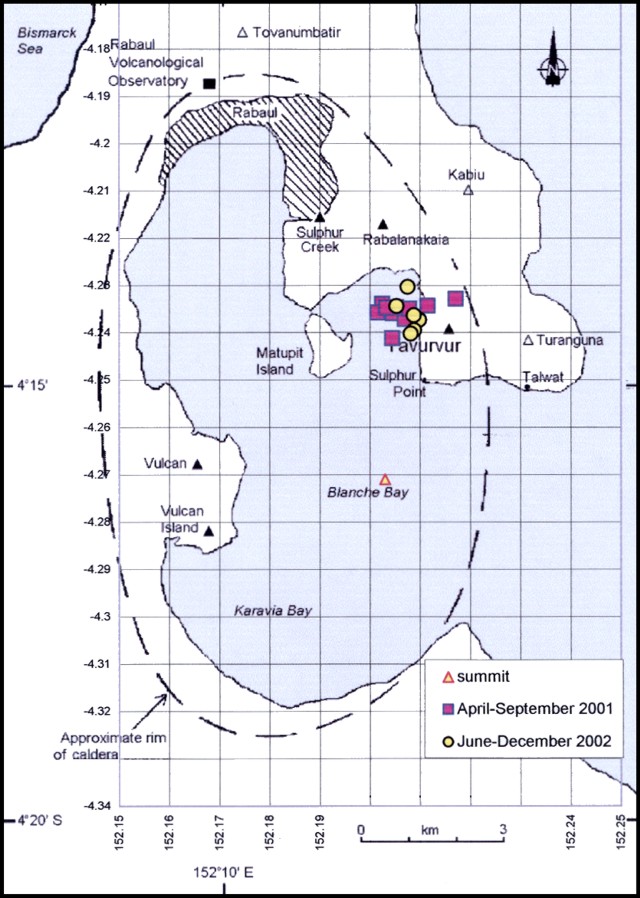 |
Figure 37. Locations of alert-pixels at Rabaul during 2001-2002. Base map from BGVN 25:07 (modified from Almond and McKee, 1982). Courtesy of Diego Coppola and David Rothery, The Open University. |
The first alert was detected on 26 April 2001, and can be related to a change in activity on Tavurvur from occasional sub-continuous ash emissions to frequent, short-duration ash expulsions on 25 April (BGVN 26:06). From 21 May to 2 June MODIS detected a series of anomalies characterized by a single pixel (two pixels on 26 May) with a low alert ratio averaging -0.774. For this period RVO reported incandescent explosions that lessened in frequency and vigor towards the end of May but picked up again on 30 May when explosions produced dark ash clouds that rose to 1-1.5 km above the vent. On 1-2 June activity was dominated by strong discrete explosions. At night, red incandescent lava fragments were visible (BGVN 26:10). On 4 July 2001 MODIS detected a moderate anomaly coincident with Tavurvur cone, characterized by two alert-pixels with a maximum alert ratio of -0.263. The anomaly was much smaller on 6 July. Reports by RVO (BGVN 26:10) indicated a quiet period from 20 June through July and most of August marked by emission of thin, white vapor. Activity remained low throughout September and October (BGVN 26:10). MODIS detected a single alert-pixel on 17 September, possibly corresponding to the last ash-producing activity in early September 2001.
The next MODIS alerts were in 2002 on 14 June, 19 September, 22 October, 21 November, and 25 December. These were single pixels except for the 22 October anomaly, which was 2 pixels in size. This may represent the aftermath of a large explosion on 20 October that produced a thick, dark ash plume that rose 3 km (BGVN 27:11).
Reference. Almond, R.A., and McKee, C.O., 1982, Location of volcano-tectonic earthquakes within the Rabaul Caldera: Geological Survey of Papua New Guinea Report 82/19.
Geological Summary. The low-lying Rabaul caldera on the tip of the Gazelle Peninsula at the NE end of New Britain forms a broad sheltered harbor utilized by what was the island's largest city prior to a major eruption in 1994. The outer flanks of the asymmetrical shield volcano are formed by thick pyroclastic-flow deposits. The 8 x 14 km caldera is widely breached on the east, where its floor is flooded by Blanche Bay and was formed about 1,400 years ago. An earlier caldera-forming eruption about 7,100 years ago is thought to have originated from Tavui caldera, offshore to the north. Three small stratovolcanoes lie outside the N and NE caldera rims. Post-caldera eruptions built basaltic-to-dacitic pyroclastic cones on the caldera floor near the NE and W caldera walls. Several of these, including Vulcan cone, which was formed during a large eruption in 1878, have produced major explosive activity during historical time. A powerful explosive eruption in 1994 occurred simultaneously from Vulcan and Tavurvur volcanoes and forced the temporary abandonment of Rabaul city.
Information Contacts: Ima Itikarai, Rabaul Volcano Observatory (RVO), P.O. Box 386, Rabaul, Papua New Guinea; Diego Coppola and David A. Rothery, Department of Earth Sciences, The Open University, Milton Keynes, MK7 6AA, United Kingdom.