Report on Merapi (Indonesia) — March 2003

Bulletin of the Global Volcanism Network, vol. 28, no. 3 (March 2003)
Managing Editor: Edward Venzke.
Merapi (Indonesia) Infrared satellite data show continuous activity through mid-January 2002
Please cite this report as:
Global Volcanism Program, 2003. Report on Merapi (Indonesia) (Venzke, E., ed.). Bulletin of the Global Volcanism Network, 28:3. Smithsonian Institution. https://doi.org/10.5479/si.GVP.BGVN200303-263250
Merapi
Indonesia
7.54°S, 110.446°E; summit elev. 2910 m
All times are local (unless otherwise noted)
During late July-1 September 2002, the Volcanological Survey of Indonesia (VSI) reported frequent lava avalanches and plumes up to 550 m above the summit of Merapi (BGVN 27:09). No further reports were issued by VSI through at least March 2003.
MODIS thermal alerts during 2001 and 2002 indicated continuous activity through mid-January 2002 (figures 24 and 25). This period was characterized by dome collapse and hot avalanches (BGVN 26:01, 26:07, 26:10, and 27:02). Pyroclastic flows occurred too frequently to correlate them with the MODIS alerts, for which data are collected only about once per day (weather permitting). There were no alerts detected during the rest of 2002 except for late March-late May, which corresponded to a temporary renewal of pyroclastic flows before a quieter second half of the year (BGVN 27:06 and 27:09).
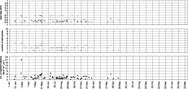 |
Figure 24. MODIS-detected alerts on Merapi during 2001-2002. Thermal alerts collated by Diego Coppola and David Rothery; data courtesy of the Hawaii Institute of Geophysics and Planetology's MODIS Thermal Alert Team. |
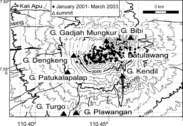 |
Figure 25. Center coordinates of alert-pixels on Merapi, relative to the published summit location. Grid squares are 1 km. Thermal alerts collated by Diego Coppola and David Rothery; data courtesy of the Hawaii Institute of Geophysics and Planetology's MODIS Thermal Alert Team. |
Geological Summary. Merapi, one of Indonesia's most active volcanoes, lies in one of the world's most densely populated areas and dominates the landscape immediately north of the major city of Yogyakarta. It is the youngest and southernmost of a volcanic chain extending NNW to Ungaran volcano. Growth of Old Merapi during the Pleistocene ended with major edifice collapse perhaps about 2,000 years ago, leaving a large arcuate scarp cutting the eroded older Batulawang volcano. Subsequent growth of the steep-sided Young Merapi edifice, its upper part unvegetated due to frequent activity, began SW of the earlier collapse scarp. Pyroclastic flows and lahars accompanying growth and collapse of the steep-sided active summit lava dome have devastated cultivated lands on the western-to-southern flanks and caused many fatalities.
Information Contacts: Dali Ahmad, Volcanological Survey of Indonesia (VSI), Jalan Diponegoro No. 57, Bandung 40122, Indonesia (URL: http://www.vsi.esdm.go.id/); Diego Coppola and David A. Rothery, Department of Earth Sciences, The Open University, Milton Keynes, MK7 6AA, UK. Thermal alerts courtesy of the HIGP MODIS Thermal Alerts Team (URL: http://modis.higp.hawaii.edu/).