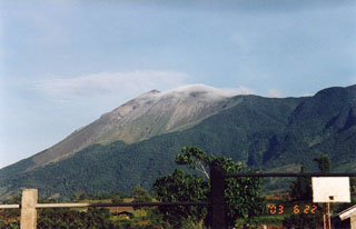
Report on Kanlaon (Philippines) — June 2003
Bulletin of the Global Volcanism Network, vol. 28, no. 6 (June 2003)
Managing Editor: Edward Venzke.
Kanlaon (Philippines) Ash-and-steam explosions between 23 May and 4 July; minor ashfall on 8 June
Please cite this report as:
Global Volcanism Program, 2003. Report on Kanlaon (Philippines) (Venzke, E., ed.). Bulletin of the Global Volcanism Network, 28:6. Smithsonian Institution. https://doi.org/10.5479/si.GVP.BGVN200306-272020
Kanlaon
Philippines
10.4096°N, 123.13°E; summit elev. 2422 m
All times are local (unless otherwise noted)
Following an ash emission from Canlaon on 17 March 2003 (BGVN 28:03), the Philippine Institute of Volcanology and Seismology (PHIVOLCS) raised the hazard status to Alert Level 1 (on a scale of 0-5), which signified possible ash explosions in the coming days or weeks. There was another ash emission on 23 May.
Beginning on 1 June, the seismic network detected an average of five low-frequency volcanic earthquakes per day. Moderate steaming was noted, which is unusual for Canlaon because steam is typically wispy or nonexistent during normal and quiet conditions.
Brief bursts of ash and steam reaching 100 m above the active crater were observed on 1, 3, 4, 5, 6, 7, and 8 June. An ash emission during 0645-0700 on 8 June deposited traces of ash at Canlaon City proper and in the barangays of Masulog and Linutangan. Eight low-frequency volcanic earthquakes and four low-frequency short-duration harmonic tremors were recorded in the 24-hour period prior to the event. In addition, PHIVOLCS seismographs in Cabagnaan (6 km SW of the active crater) and Canlaon City (8.7 km SE) detected episodes of low-frequency tremor.
Small ash ejections continued after 8 June. Ash-and-steam columns rose to 1,000 m before drifting SSE and SE. Ash explosions on 13 June between 0647 and 0756 were recorded at Cabagnaan as low-frequency short-duration harmonic tremors. The explosions produced voluminous dirty-white steam which rose to ~500 m and drifted SSE and ESE. Six low-frequency volcanic earthquakes and three low-frequency short-duration harmonic tremors were detected the 24 hours prior to the event.
Two small steam-driven explosions occurred during 0820-0835 and 1020-1030 on 17 June. The ejected ash-and-steam columns rose to ~400 m above the summit crater and drifted NNE. In the 24-hour period prior to the explosions, the volcano's seismic network detected eight low-frequency volcanic earthquakes, two high-frequency volcanic earthquakes, and one low-frequency short-duration harmonic tremor.
A mild ash ejection at 1422 on 18 June was recorded as a low-frequency volcanic earthquake. A grayish ash-and-steam cloud rose ~ 400 m above the summit crater before drifting SE. Only two low-frequency volcanic earthquakes and one short-duration harmonic tremor preceded the explosion. Mild ash explosions occurred during 0701-0707, 0743-0750, and 1420-1430. These explosions produced voluminous ash-and-steam clouds that rose 400 m above the summit crater before drifting NW. The events were reflected in seismic records as low-frequency volcanic earthquakes. In the 24-hour period prior to the events, two low-frequency earthquakes, one high-frequency volcanic earthquake, and one short-duration harmonic tremor were recorded by the seismic network.
The volcano continued to manifest moderate steaming and ash emission activity with an ash column rising ~900 m above the summit crater at 0515 on 4 July. In the 24-hour period prior to the event the seismic network recorded five low-frequency volcanic earthquakes and two low-frequency short-duration harmonic tremors.
The hazard status during June and July remained at Alert Level 1, and PHIVOLCS reminded the public to avoid entering the 4-km-radius Permanent Danger Zone. The absence of longer duration harmonic tremor suggested to PHIVOLCS that there was no magma movement or intrusion, indicating that the explosions were possibly a result of reactivation of a shallow hydrothermal system.
Geological Summary. Kanlaon volcano (also spelled Canlaon) forms the highest point on the Philippine island of Negros. The massive andesitic stratovolcano is covered with fissure-controlled pyroclastic cones and craters, many of which are filled by lakes. The largest debris avalanche known in the Philippines traveled 33 km SW from Kanlaon. The summit contains a 2-km-wide, elongated northern caldera with a crater lake and a smaller but higher active vent, Lugud crater, to the south. Eruptions recorded since 1866 have typically consisted of phreatic explosions of small-to-moderate size that produce minor local ashfall.
Information Contacts: Philippine Institute of Volcanology and Seismology (PHIVOLCS), Department of Science and Technology, PHIVOLCS Building, C.P. Garcia Avenue, University of the Philippines Campus, Diliman, Quezon City, Philippines (URL: http://www.phivolcs. dost.gov.ph/).

