Report on Arenal (Costa Rica) — August 2003

Bulletin of the Global Volcanism Network, vol. 28, no. 8 (August 2003)
Managing Editor: Edward Venzke.
Arenal (Costa Rica) Ongoing lava extrusion and intermittent pyroclastic flows late 2001 through mid-2003
Please cite this report as:
Global Volcanism Program, 2003. Report on Arenal (Costa Rica) (Venzke, E., ed.). Bulletin of the Global Volcanism Network, 28:8. Smithsonian Institution. https://doi.org/10.5479/si.GVP.BGVN200308-345033
Arenal
Costa Rica
10.463°N, 84.703°W; summit elev. 1670 m
All times are local (unless otherwise noted)
This report concerns Arenal behavior during November 2001 through August 2003, although some reports were absent (specifically, November and December 2001 and January, February, and April 2002). The available reports portrayed an interval with only a few pyroclastic flows and with plumes generally under 500 m. Lava flows continued to travel down Arenal's slopes; in many cases these flows did not follow well-defined channels. Spatter and related deposition from crater C caused a slightly higher summit elevation. During 2002 lavas descended along many routes down the W, NW, N, and NE flanks. Seismicity remained prominent during the interval, with the number of monthly eruption signals in the hundreds (200-800) and monthly tremor duration in the hundreds of hours.
Seismicity registered during March 2000-December 2001 and for the year 2002 appears as figures 96 and 97, where the numbers of eruptions plotted monthly were inferred. The seismic station VACR (table 22) returned to service on 28 March 2000, registering totals for four days at the end of March consisting of 164 eruptions and 45 hours of tremor. Also reported this month, the electronic distance measuring network (sub-radial lines) continued to show a contraction averaging 7-10 ppm per year. Similar conclusions were stated for August 2003, although in that case deflation was only mentioned on Arenal's W flank. In accord with that observation, dry tilt in the radial direction showed a deflation equivalent to 5 µrad per year, a value that has prevailed through mid-2003.
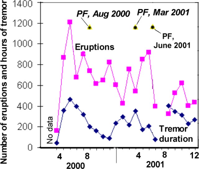 |
Figure 96. Arenal seismicity registered during March 2000-December 2001 (eruptions inferred). The blank areas before March 2000 and during July 2001 were due to equipment down-times. Known pyroclastic flows are shown, but some may be missing because some monthly reports were not available. Courtesy of OVSICORI-UNA. |
 |
Figure 97. Arenal seismicity registered during 2002 (eruption counts seismically inferred). Note change in scale compared to previous figure. The number of eruptions decreased compared to those registered in the year 2000. On the other hand, long-period (LP) earthquakes grew substantially in number during the last months of 2002; tremor repeatedly reached over 400 hours per month during mid-2002. Courtesy of OVSICORI-UNA. |
Table 22. Background describing the OVSICORI-UNA seismic station at Arenal (station VACR), as well as the typical kinds of seismic and audible acoustical signals and corresponding eruptive conditions. Courtesy of OVSICORI-UNA.
| Seismic Station Features | |
| Name | VACR |
| Location | 10.477°N, 84.684°W |
| Elevation | 360 m |
| Location relative to crater | 2.7 km NNE |
| Instrument | Ranger SS-short-period (1 Hz) |
| Gain | 60 decibels (dB) |
| Amplification | 9,605-times normalized at 1 Hz |
| Typical seismic signals recorded at Arenal include those registered in association with explosions and gas eruptions; these signals often correspond to sounds similar to a locomotive or jet engine. Tremors typically correlate to strong degassing and discharge of lava flows. The following types of tremor signal are known to occur: low frequency (typically less than 2.0 Hz), mid-frequency (typically 2.0-3.0 Hz), high frequency (typically above 3.0 Hz), polychromatic (occurring in any frequency range), monochromatic (low-frequency range), and spasmodic (high-frequency range). | |
The number of monthly earthquakes generally dropped or held steady during 2002 compared to 2000-2001 (figure 97). Tremor duration, however, did increase through July 2002, approaching 700 hours a month, typically several times larger than seen in the previous two years. Long-period (LP) earthquakes suddenly became prominent in November and December 2002 (roughly 3- to 7-fold more numerous than seen earlier in 2002).
Two prominent PFs occurred during 2000-2001: in August 2000 and March 2001. They did not correlate with short-term increases in precursory seismicity. However, the August 2000 PF took place after clear increases in the number of earthquakes, the duration of tremor (figure 96), and the number of explosions.
One of a series of PFs judged smaller than the one in March occurred on 16 June 2001. They descended the NW flank for an unstated distance in the direction of Balneario de Tabacón (the Tabacón hot springs and resort complex). Associated seismic signals persisted for ~48 minutes. Although seismicity during June 2001 was comparatively low overall, May 2001 seismicity was moderately high, although not outstanding (figure 96).
During March 2002, Arenal's lava traveled down the N and NE flanks. Eruptive vigor remained low in terms of the number of eruptions and quantity of ejected pyroclastics. On the NE, E, and SE flanks there had been acidic rains and tephra falls. These, in combination with the steep slopes, unconsolidated material, and high rainfall, had caused vegetation to recede. This led to greater erosion, and small cold avalanches swept down the drainages Calle de Arenas, Manolo, Guillermina, and Agua Caliente.
On 18 May 2002 a pyroclastic flow resulted from the structural failure of a lava channel's margin in the region adjacent to the active crater (Crater C). The pyroclastic flow descended to ~900 m elevation, traveling roughly NW. Otherwise, the eruptive vigor around this time continued to remain low; a few eruptions produced columns that rose ~500 m above Crater C. Some minor changes took place in the lava flow channels during May 2002.
Although reports for June and July 2002 were absent during the preparation of this report, the August report mentioned sporadic Strombolian eruptions during those months. Lava that began to be emitted in May 2002 traveled NW and stopped during August. After that, a new lava flow began during August, heading NW in its upper reaches. Very close to the crater, it divided into two arms, heading W and NW. The August effusive activity had increased over recent months, yet, overall the eruptive vigor around that time generally remained low with few eruptions bearing ash, and columns failing to rise more than 500 m above crater C's summit.
Low activity again prevailed during September-December 2002, but lava flows continued to emerge. During September lavas were active on Arenal's W flank, and to some extent on its NW, N, and NE flanks. During October, lavas chiefly descended the NW slopes. During November, the NW-flank lava flow that began to be emitted during August 2002 stopped advancing. A new lava flow began to descend the W flank. Flows down the NW-NE flanks were noted in reports for December 2002-August 2003. In addition, during December 2002 and January and August 2003, some lavas appeared active on the SW flank. During January 2003 plumes again rose to under 500 m high, and calm generally prevailed in February through August as well. Two noteworthy events broke the relative calm of 2003; these occurred during February, May, and September.
On 21 February 2003 at about 0825, NE-flank residents witnessed a small pyroclastic flow descending the same flank. Other details were not disclosed in the OVSICORI-UNA reports; nor was the May PF much described. The 5 September 2003 PF will be discussed in a later report.
Geological Summary. Conical Volcán Arenal is the youngest stratovolcano in Costa Rica and one of its most active. The 1670-m-high andesitic volcano towers above the eastern shores of Lake Arenal, which has been enlarged by a hydroelectric project. Arenal lies along a volcanic chain that has migrated to the NW from the late-Pleistocene Los Perdidos lava domes through the Pleistocene-to-Holocene Chato volcano, which contains a 500-m-wide, lake-filled summit crater. The earliest known eruptions of Arenal took place about 7000 years ago, and it was active concurrently with Cerro Chato until the activity of Chato ended about 3500 years ago. Growth of Arenal has been characterized by periodic major explosive eruptions at several-hundred-year intervals and periods of lava effusion that armor the cone. An eruptive period that began with a major explosive eruption in 1968 ended in December 2010; continuous explosive activity accompanied by slow lava effusion and the occasional emission of pyroclastic flows characterized the eruption from vents at the summit and on the upper western flank.
Information Contacts: E. Fernández, E. Duarte, E. Malavassi, R. Sáenz, V. Barboza, R. Van der Laat, T. Marino, E. Hernández, and F. Chavarría, Observatorio Vulcanológico y Sismológico de Costa Rica (OVSICORI-UNA), Apartado 86-3000, Heredia, Costa Rica.