Report on El Chichon (Mexico) — May 2004
Bulletin of the Global Volcanism Network, vol. 29, no. 5 (May 2004)
Managing Editor: Richard Wunderman.
El Chichon (Mexico) Photos of crater lake and volcanic morphology
Please cite this report as:
Global Volcanism Program, 2004. Report on El Chichon (Mexico) (Wunderman, R., ed.). Bulletin of the Global Volcanism Network, 29:5. Smithsonian Institution. https://doi.org/10.5479/si.GVP.BGVN200405-341120
El Chichon
Mexico
17.3602°N, 93.2297°W; summit elev. 1150 m
All times are local (unless otherwise noted)
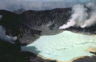
The Bulletin staff received numerous photographs of currently non-eruptive El Chichón from amateur photographer King Freeland; a few are included below. Some of Freeland's photos are wide-angle montages compiled from multiple photos using image-processing software. The photograph in figure 5 was taken in April 2004 and shows the warm, bright green, acidic crater lake. Figure 6 illustrates the central crater as it looked in May 2004 from the SE side of the volcano looking towards the WSW.
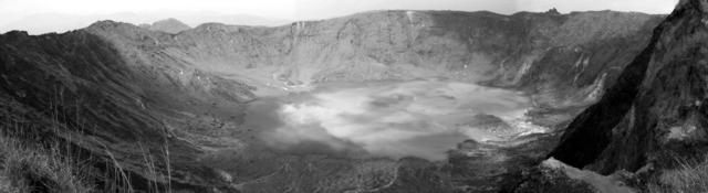 |
Figure 5. Photograph taken in April 2004 from the SW crater rim of El Chichón showing the crater lake. Courtesy of King Freeland. |
 |
Figure 6. The S side of El Chichón's inner crater, May 2004, looking toward WSW. Courtesy of King Freeland. |
Figure 7 depicts a sequence of what resemble stair steps developed on the pyroclastic deposits. Yuri Taran estimated the approximate height of these "steps" as 0.5-1 m, but the photographer Freeland suggested a height of up to 3 m. Taran and Freeland both offered that the features may result from the work of water, and Taran also suggested wind as a possibility.
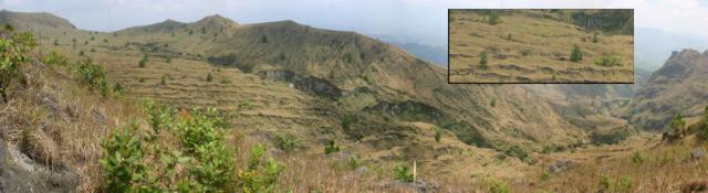 |
Figure 7. Broken 'stair-stepped' surface developed on pyroclastic deposits at El Chichón. The inset at upper right is a blow-up of a representative area in the photo's center. The photo was taken in 2004. Courtesy of King Freeland. |
Taran lamented the lack of people studying these features, even though they appeared quite spectacular, stating "We need a team of geographers to study this type of erosion, soil formation..." Many of Freeland's other photos in our archives also depict fumarolic and hydrothermal features.
Yuri Taran from the Institute of Geophysics, Universidad Nacional Autonoma de Mexico (UNAM), has been studying El Chichón volcano and its hydrothermal activity for almost 10 years (see Capaccioni and others, 2004). Taran noted that three groups of hot springs exist on the slopes of the volcano: Agua Caliente, S of the volcano with a maximum temperature of 74°C; Agua Salada, at the base of the dome, SSW from the crater, with a maximum temperature of 55°C; and Agua Tibia, NW of the crater with an estimated maximum temperature of ~ 51°C. The crater lake has variable shape and size, depending on the flow rate of a boiling spring in the crater that feeds the lake. When this spring sometimes disappears, the lake becomes smaller until an equilibrium develops between precipitation, evaporation, and seepage through the lake bottom. This 'equilibrium' lake size is quite small. Taran noted that during the period of his study the lake was smallest in November 1998 (at the end of the rainy season), and it was very shallow, ~1.3 m deep.
References. Capaccioni, B., Taran, Y., Tassi, F., Vaselli, O., Mangani, G., and Macias, J.L., 2004, Source conditions and degradation processes of light hydrocarbons in volcanic gases: an example from El Chichón volcano (Chiapas State, Mexico), Chemical Geology, v. 206, nop. 1-2, p.81-96.
Geological Summary. El Chichón is a small trachyandesitic tuff cone and lava dome complex in an isolated part of the Chiapas region in SE México. Prior to 1982, this relatively unknown volcano was heavily forested and of no greater height than adjacent non-volcanic peaks. The largest dome, the former summit of the volcano, was constructed within a 1.6 x 2 km summit crater created about 220,000 years ago. Two other large craters are located on the SW and SE flanks; a lava dome fills the SW crater, and an older dome is located on the NW flank. More than ten large explosive eruptions have occurred since the mid-Holocene. The powerful 1982 explosive eruptions of high-sulfur, anhydrite-bearing magma destroyed the summit lava dome and were accompanied by pyroclastic flows and surges that devastated an area extending about 8 km around the volcano. The eruptions created a new 1-km-wide, 300-m-deep crater that now contains an acidic crater lake.
Information Contacts: King Freeland, Distrito Reynosa 157, Fracc. Pages Llergo, Villahermose, Tabasco, CP86125, México; Yuri Taran, Instituto de Geofisica, Universidad Nacional Autonoma de México (UNAM), Ciudad Universitaria, Coyaocan 04510, México D.F., México (URL: http://www.geofisica.unam.mx/).