Report on Deception Island (Antarctica) — December 2004
Bulletin of the Global Volcanism Network, vol. 29, no. 12 (December 2004)
Managing Editor: Richard Wunderman.
Deception Island (Antarctica) Annual investigations reveal continuing seismicity and fumaroles
Please cite this report as:
Global Volcanism Program, 2004. Report on Deception Island (Antarctica) (Wunderman, R., ed.). Bulletin of the Global Volcanism Network, 29:12. Smithsonian Institution. https://doi.org/10.5479/si.GVP.BGVN200412-390030
Deception Island
Antarctica
62.9567°S, 60.6367°W; summit elev. 602 m
All times are local (unless otherwise noted)
Deception Island is the most active volcano in the Antarctic Peninsula region. A team of Spanish-Argentine scientists collected data from 25 November 2003 to 16 March 2004 in order to provide background activity records. Local and regional seismicity, thermal activity, gas emission, geodetic, and geological studies were carried out. During this survey, one seismic antenna and three continuous-recording stations were installed (figure 20). One dense seismic antenna with twelve vertical-component short-period seismometers was located between the Spanish and Argentine base stations, one vertical-component short-period seismometer was placed at North Fumarole Bay (with telemetry), and three-component short-period seismic stations were installed near both the "Gabriel de Castilla" Spanish station and the Argentine station.
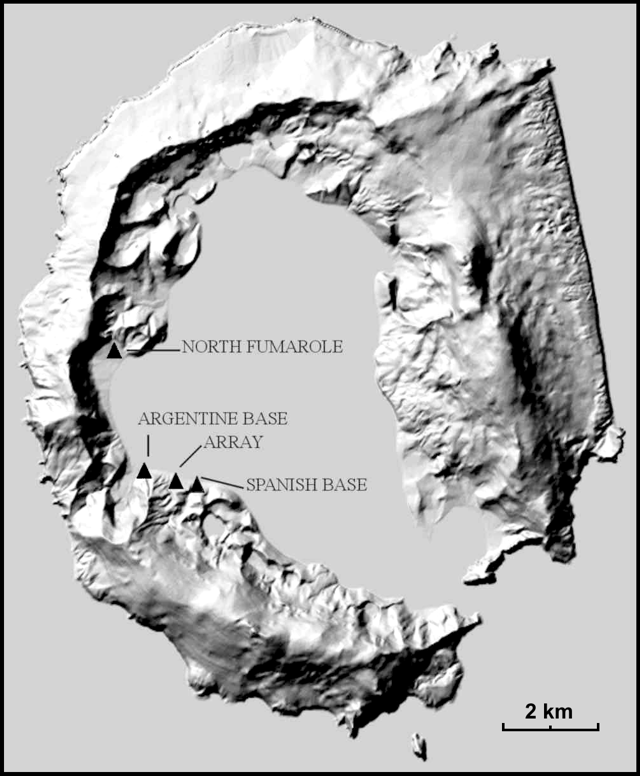 |
Figure 20. Seismological stations deployed at Deception Island in 2003-2004 summer survey. Courtesy of the Spanish-Argentine research team. |
The recorded seismicity included long-period events (LP), volcanic-tremor episodes (T), and a few volcano-tectonic earthquakes (VT). More than 3,660 LP events events were recorded (figure 21), 35 of them with hybrid character, and many with frequencies of 1-8 Hz. Eight volcanic tremors occurred with durations ranging from less than one hour to twenty-one hours; 66 VT earthquakes were also recorded. Four remarkable periods of activity were detected in this survey, during last December, mid-January, early February, and mid-March. All of these periods were characterized by a relatively high level of seismic activity with frequent LP events and tremor. Most earthquakes recorded during the field season were located inside the island, and these events have been closely related with LP and tremor events. Earthquakes with S-P wave time lags of less than 3 seconds were classified as local or VT, with local magnitudes of up to 2.0, none of which were felt. LP seismicity might be related to thaw water (seasonal effect) but this year's anomalous activity could also be due to strong pressurization in a sealed system.
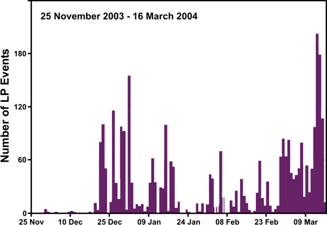 |
Figure 21. Long-period seismic activity at Deception Island during the 2003-2004 summer survey. Adapted from a histogram showing six types of recorded seismicity. Courtesy of the Spanish-Argentine research team. |
Fumarole temperatures and hot soils remained stable between 99 and 101°C in Fumarole Bay, 95°C in Caliente hill, 65°C in Whalers Bay, 41°C in Telefon Bay, and 72°C in Pendulum Cove. Systematic monitoring of fumarolic activity continued as in past years, and during this survey radon was measured. Samples of condensable and uncondensable acid gases were collected. The obtained composition from the fumarole vents at Fumarole Bay was similar to previous years. The average chemical composition of the fumarolic gases was H2O(v) (86.21%), CO2 (13.59%), H2S (0.19%), and SO2 (0.01%). Lapilli with a coating of pyrite were found around vent outlets. Compositional changes in acidic gases observed in early February and March 2004 correlated with increased seismicity, especially with LP events.
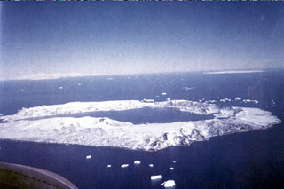
Geological Summary. Ring-shaped Deception Island, at the SW end of the South Shetland Islands, NE of Graham Land Peninsula, was constructed along the axis of the Bransfield Rift spreading center. A narrow passageway named Neptunes Bellows provides an entrance to a natural harbor within the 8.5 x 10 km caldera that was utilized as an Antarctic whaling station. Numerous vents along ring fractures circling the low 14-km-wide island have been reported active for more than 200 years. Maars line the shores of 190-m-deep Port Foster caldera bay. Among the largest of these maars is 1-km-wide Whalers Bay, at the entrance to the harbor. Eruptions during the past 8,700 years have been dated from ash layers in lake sediments on the Antarctic Peninsula and neighboring islands.
Information Contacts: A.T. Caselli, C. Bengoa, and E. Rojas Vera, Universidad de Buenos Aires-Instituto Antártico Argentino, Ciudad Universitaria, Pab.2, (1428) Buenos Aires, Argentina; A. Bidone and G. Badi, Dpto. de Sismología e I.M., Facultad de Cs. Astronóm. y Geofísicas, UNLP, Av. Centenario s/n Paseo del Bosque, B1900FWA La Plata, Pcia. de Buenos Aires, Argentina; Daria Zandomeneghi, Nieves Sánchez, Fermín Fernández-Ibañez, and Jesús Ibáñez, Instituto Andaluz de Geofísica y P.D.S. Universidad de Granada, Campus Universitario de Cartuja, s/n 18071, Granada, Spain.