Report on Awu (Indonesia) — April 2005
Bulletin of the Global Volcanism Network, vol. 30, no. 4 (April 2005)
Managing Editor: Richard Wunderman.
Awu (Indonesia) Stable during mid- to late August 2004
Please cite this report as:
Global Volcanism Program, 2005. Report on Awu (Indonesia) (Wunderman, R., ed.). Bulletin of the Global Volcanism Network, 30:4. Smithsonian Institution. https://doi.org/10.5479/si.GVP.BGVN200504-267040
Awu
Indonesia
3.689°N, 125.447°E; summit elev. 1318 m
All times are local (unless otherwise noted)
Awu's eruption on 6 June 2004 and its elevated seismicity in early August 2004 was previously reported (BGVN 29:10). This report covers the last half of August 2004, which had not been reported on previously. Since the 6 June eruption, observation of the summit failed to reveal any significant changes (table 3). The hazard status of Awu during this August report remained at Level 2, having been elevated to 4 (the highest on a scale of 1 to 4) at the time of the 6 June eruption and then lowered on 14 June.
Table 3. Seismicity at Awu during August 2004 as reported by DVGHM.
| Date | Deep Volcanic (A-type) | Shallow Volcanic (B-type) | Tectonic |
| 09 Aug-15 Aug 2004 | -- | -- | 75 |
| 16 Aug-22 Aug 2004 | 2 | 1 | 81 |
| 23 Aug-29 Aug 2004 | 2 | -- | 102 |
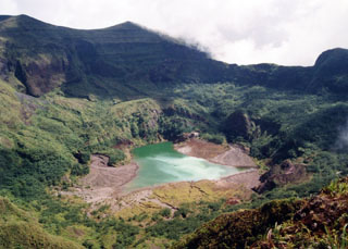
Geological Summary. The massive Gunung Awu stratovolcano occupies the northern end of Great Sangihe Island, the largest of the Sangihe arc. Deep valleys that form passageways for lahars dissect the flanks of the volcano, which was constructed within a 4.5-km-wide caldera. Powerful explosive eruptions in 1711, 1812, 1856, 1892, and 1966 produced devastating pyroclastic flows and lahars that caused more than 8000 cumulative fatalities. Awu contained a summit crater lake that was 1 km wide and 172 m deep in 1922, but was largely ejected during the 1966 eruption.
Information Contacts: Dali Ahmad, Directorate of Volcanology and Geological Hazard Mitigation (DVGHM), Jalan Diponegoro 57, Bandung 40122, Indonesia (URL: http://www.vsi.esdm.go.id/).